Real-time navigation method based on road condition

A navigation method and technology of road conditions, applied in the directions of road network navigator, navigation, mapping and navigation, can solve problems such as congestion, affect navigation efficiency, road congestion problem is not very effective, and achieve strong real-time performance and improve navigation efficiency. Effect

Inactive Publication Date: 2016-10-12
NANJING COLLEGE OF INFORMATION TECH
View PDF6 Cites 20 Cited by
  • Summary
  • Abstract
  • Description
  • Claims
  • Application Information

AI Technical Summary

Problems solved by technology

This method can effectively avoid roads with problems such as road maintenance closures, traffic control or traffic accidents, but it is not very effective for road congestion problems, because sometimes there is no congestion when querying, but it may become very congested after a period of time , which also affects the navigation efficiency

Method used


Image

  • Real-time navigation method based on road condition
  • Real-time navigation method based on road condition
  • Real-time navigation method based on road condition

Examples


Embodiment Construction

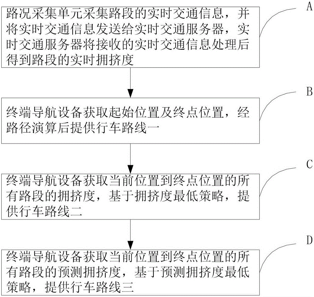
[0030] The real-time navigation method based on road conditions will be described in detail below in conjunction with specific embodiments and accompanying drawings.

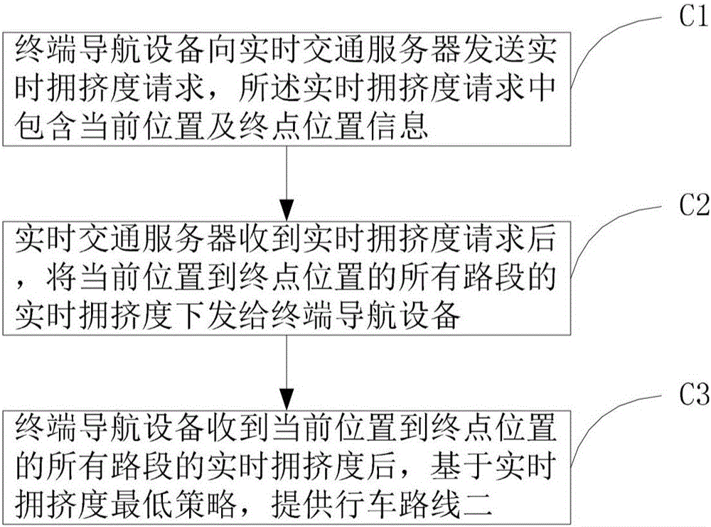
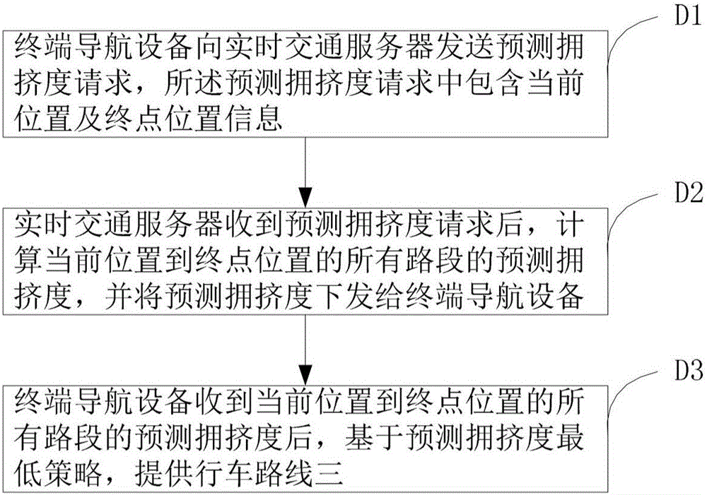
[0031] The navigation system used in the present invention includes a road condition collection unit, a real-time traffic server and a terminal navigation device. The road condition acquisition unit can include some existing traffic facilities, such as geomagnetic coils at intersections, toll facilities on expressways, speed measurement systems and monitoring, etc., and can also include control centers for traffic sentry boxes and patrol cars, call centers for 110 and 122, and weather Forecasting center, etc.; the real-time traffic server includes a communication unit, a processing unit and a storage unit, the communication unit is used for data transmission with the road condition collection unit and terminal navigation equipment, the processing unit is used for executing the data operation program, and the stor...


PUM


Abstract

The invention discloses a real-time navigation method based on road conditions. The method comprises: a road condition acquisition unit periodically collects real-time traffic information of each road section, and sends the real-time traffic information to a real-time traffic server, and the real-time traffic server receives the real-time traffic information After information processing, the real-time congestion degree of each road section is obtained; the terminal navigation device obtains the starting position and the end position, and provides driving route 1 after path calculation; the terminal navigation device obtains the congestion degree of each road section from the current position to the end position, based on the congestion degree The lowest strategy provides driving route 2; the terminal navigation device obtains the predicted congestion degree of each road section from the current position to the terminal position after a predetermined time period, and provides driving route 3 based on the lowest predicted congestion degree strategy. Compared with the prior art, the present invention enables users to conveniently and clearly know the real-time road conditions on the way and the predicted road conditions after a period of time, provides three routes for users to choose, has strong real-time performance, and improves navigation efficiency.

Description

technical field [0001] The invention belongs to the field of traffic intelligent management, in particular to a real-time navigation method based on road conditions. Background technique [0002] Currently, the commonly used navigation method is to search for a route in a static road network based on the shortest time or the shortest route, and provide a navigation route. But sometimes driving along the navigation route will encounter emergencies such as road maintenance closures, traffic control or traffic accidents, which will bring great inconvenience to travel. The optimal driving route is closely related to real-time road conditions. The traditional way to obtain road traffic information is to listen to the radio. This method has poor real-time performance, small coverage and is not intuitive. With the development of related technologies, people can query real-time road conditions through related software, so as to plan routes. This method can effectively avoid roads ...

Claims


Application Information

Patent Timeline
Patent Type & Authority Applications(China)
IPC IPC(8): G01C21/34
CPCG01C21/3492
Inventor 金明聂佰玲周波髙燕吴珊珊
Owner NANJING COLLEGE OF INFORMATION TECH
Why Eureka
Try Eureka