A city space growth ring map making and analyzing method

An analysis method and urban technology, applied in geographic information databases, special data processing applications, instruments, etc., can solve the problems of no urban spatial annual ring analysis map technology, lack of time series research, etc., and achieve the goal of simplifying the complex software operation process Effect

Active Publication Date: 2016-10-12
ARCHITECTURAL DESIGN & RES INST OF SOUTHEAST UNIV CO LTD
View PDF5 Cites 15 Cited by
  • Summary
  • Abstract
  • Description
  • Claims
  • Application Information

AI Technical Summary

Problems solved by technology

[0003] At present, the main research content of urban spatial form at home and abroad is mostly the inner space of the city and the outer form of the city, relatively little use of information technology to study the evolution and development trend of urban form, most of the research based on information technology is static research, and there is a lack of dynamic time-series-based research In particular, there is no relevant analysis and research on urban spatial annual rings, and there is no urban spatial annual ring analysis map technology and invention based on geographic information systems.

Method used


Image

  • A city space growth ring map making and analyzing method
  • A city space growth ring map making and analyzing method
  • A city space growth ring map making and analyzing method

Examples


Embodiment Construction

[0037] The present invention will be further illustrated below in conjunction with the accompanying drawings and specific embodiments. It should be understood that these embodiments are only used to illustrate the present invention and not to limit the scope of the present invention. After reading the present invention, modifications of various equivalent forms of the present invention by those skilled in the art all fall within the appended claims of the present application limited range.

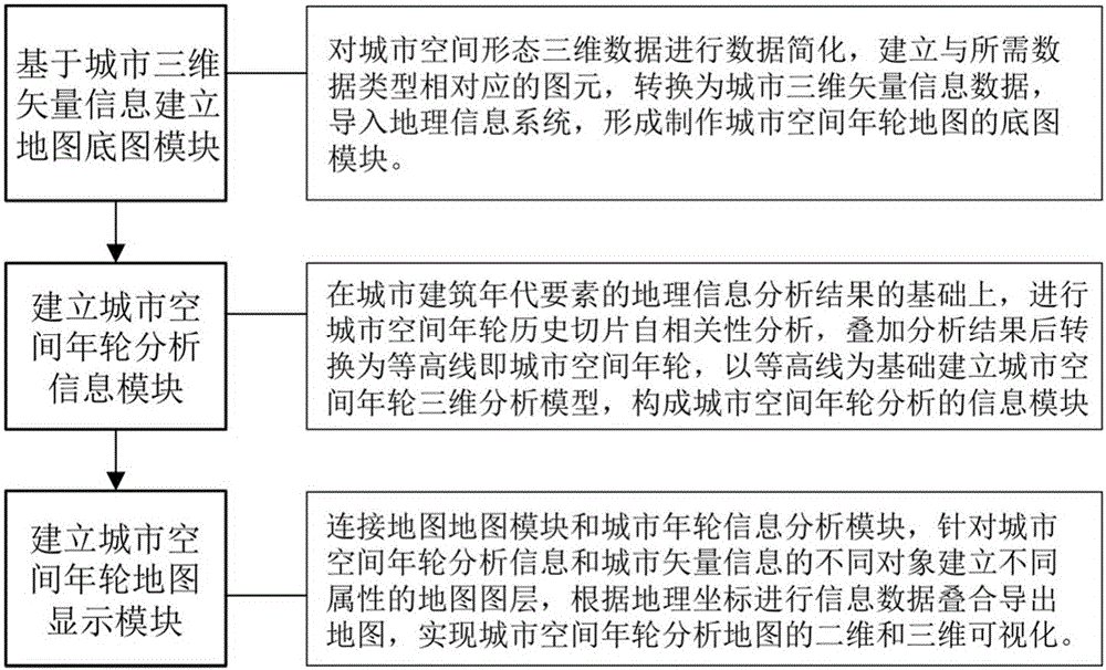
[0038] like figure 1 As shown, a method for making and analyzing an urban space annual ring map disclosed in an embodiment of the present invention mainly includes the following steps:

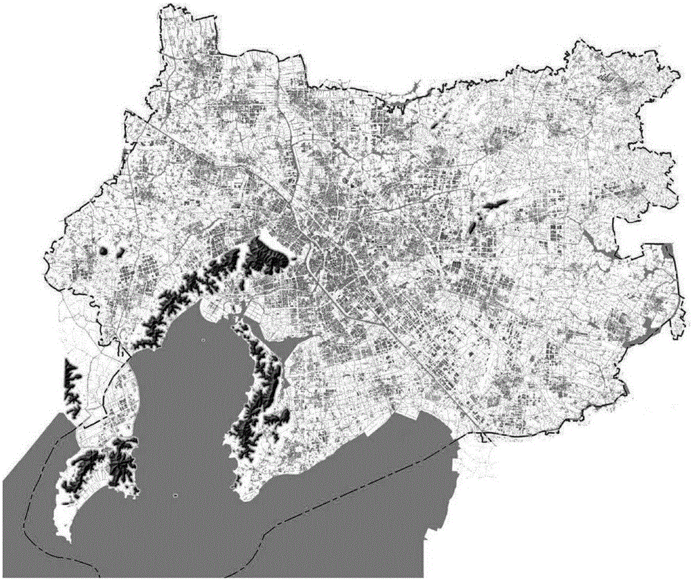
[0039] 1) Establish a map basemap module of urban space annual rings based on the three-dimensional vector information of the city;

[0040] Simplify the 3D data of urban spatial form, establish the graphic elements corresponding to the required data types, convert it into urban 3D vector information da...


PUM


Abstract

The invention provides a city space growth ring map making and analyzing method. The method comprises the steps of importing three-dimensional vector information data of a city into a geographic information system to form a map base map module; performing geographic information analysis of building distribution on buildings of different construction ages, performing city space growth ring history slice auto-correlation analysis on the basis of the geographic information analysis, superposing the analysis results and converting the results into contour lines, and establishing a city space growth ring three-dimensional analysis module based on the contour lines to form a city space growth ring analysis information module; establishing layers of different attributes for different objects of city space growth ring analysis information and city vector information, performing information data superposition according to geographic coordinates and displaying a city space growth ring map. The method correlates the city space growth ring analysis results and the geographic information, realizes geographic space demonstration of the city space growth ring analysis, can make thematic maps efficiently and conveniently, and can widely meet the current requirements of city planning and design engineering practices.

Description

technical field [0001] The invention relates to a method for making and analyzing maps, and more particularly to a method for making and analyzing urban space annual rings. Background technique [0002] Cities are the main spatial forms of human agglomeration. In the period of rapid urbanization, how to grasp the future development direction of cities, predict and control the urban spatial form has become an important issue facing urban development in my country. This requires in-depth exploration and analysis of the objective laws of the emergence and development of cities, the process and mechanism of urbanization from the perspective of spatial form and historical succession. The urban space annual ring is a further interpretation of the urban spatial form from a historical perspective. It is closely related to the urban spatial form and layout. The city presents the characteristics of historical fault slices and the law of spatial development and expansion in the shape o...

Claims


Application Information

Patent Timeline
Patent Type & Authority Applications(China)
IPC IPC(8): G06F17/30
CPCG06F16/29
Inventor 杨俊宴陆小波
Owner ARCHITECTURAL DESIGN & RES INST OF SOUTHEAST UNIV CO LTD
Why Eureka
Try Eureka