A method and system for drawing an industrial project area map

A map drawing and project technology, applied in the field of map drawing, can solve the problems of inability to provide project geographic coordinate data, waste of manpower and material resources, and inability to obtain accurate coordinate location information, and achieve the effect of offline query, improved accuracy, and accurate determination.

Active Publication Date: 2020-05-12
TAIHUA WISDOM IND GRP CO LTD
View PDF2 Cites 0 Cited by
  • Summary
  • Abstract
  • Description
  • Claims
  • Application Information

AI Technical Summary

Problems solved by technology

When designing an industrial map, the required industrial map data is provided by the customer, but most of the customers cannot provide the exact geographic coordinate data of the project. They only know the text description of the general location of the project, and cannot obtain accurate coordinate location information. A lot of manpower and material resources are wasted by manually searching for location and entering coordinate information
In addition, when the map data server is not connected to the Internet, the industrial project area map cannot achieve the purpose of offline preview and query

Method used


Image

  • A method and system for drawing an industrial project area map
  • A method and system for drawing an industrial project area map
  • A method and system for drawing an industrial project area map

Examples


Embodiment Construction

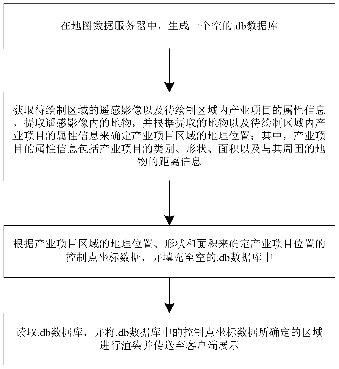
[0030] The following will clearly and completely describe the technical solutions in the embodiments of the present invention with reference to the drawings in the embodiments of the present invention. figure 1 It is a flow chart of the method for drawing an industrial project area map of the present invention, such as figure 1 The mapping of the industrial project area shown includes the following steps:

[0031] Step (1): In the map data server, generate an empty .db database;

[0032] The .db database is used to store the areal coordinate position data of the project.

[0033] Step (2): Obtain the remote sensing images of the area to be mapped and the attribute information of the industrial projects in the area to be mapped, extract the features in the remote sensing images, and determine the industry based on the extracted features and the attribute information of the industrial projects in the area to be mapped Geographical location of the project area; among them, the ...


PUM


Abstract

The invention discloses a method and system for drawing a map of an industrial project area. The method includes generating an empty .db database in a map data server; obtaining remote sensing images of the area to be drawn and attribute information of industrial items in the area to be drawn , extract the features in the remote sensing image, and determine the geographic location of the industrial project area according to the extracted features and the attribute information of the industrial project in the area to be mapped; where the attribute information of the industrial project includes the category, shape, and area of ​​the industrial project And the distance information with the surrounding features; according to the geographical location, shape and area of ​​the industrial project area, determine the control point coordinate data of the industrial project position, and fill it into the empty .db database; read the .db database, and The area determined by the control point coordinate data in the .db database is rendered and sent to the client for display.

Description

technical field [0001] The invention belongs to the field of map drawing, and in particular relates to a method and system for drawing an industrial project area map. Background technique [0002] Industrial projects include agricultural, forestry, urban and industrial projects. When designing an industrial map, the required industrial map data is provided by the customer, but most of the customers cannot provide the exact geographic coordinate data of the project. They only know the text description of the general location of the project, and cannot obtain accurate coordinate location information. A lot of manpower and material resources are wasted by manually searching for location and entering coordinate information. In addition, when the map data server is not connected to the Internet, the map of the industrial project area cannot realize the purpose of offline preview and query. Contents of the invention [0003] In order to solve the shortcomings of the prior art,...

Claims


Application Information

Patent Timeline
Patent Type & Authority Patents(China)
IPC IPC(8): G06F16/29G09B29/00
CPCG06F16/29G09B29/006
Inventor 王小光周永利张同义马述杰刘治国赵恒胜王国松洛佳明庄同光
Owner TAIHUA WISDOM IND GRP CO LTD
Why Eureka
Try Eureka