Supercharge Your Innovation With Domain-Expert AI Agents!

Geo-location or navigation type camera, aircraft, and navigation method and system thereof

A navigation system and navigation method technology, applied in the field of aircraft navigation, can solve the problems of large imaging errors, unfavorable calculation and application of ground images, etc., and achieve the effects of high accuracy, simplified flight control, and wide application range

Active Publication Date: 2017-01-11
YUNEEC TECH CO LTD
View PDF14 Cites 11 Cited by
  • Summary
  • Abstract
  • Description
  • Claims
  • Application Information

AI Technical Summary

Problems solved by technology

[0006] The technical problem to be solved by the present invention is to overcome the defects in the prior art that the ground image taken by the aircraft requires multiple imaging compensations and thus the imaging error is relatively large, and it is not conducive to the calculation and application of the ground image, and to provide a ground positioning Or navigation camera, aircraft and navigation method and system thereof

Method used


Image

  • Geo-location or navigation type camera, aircraft, and navigation method and system thereof
  • Geo-location or navigation type camera, aircraft, and navigation method and system thereof
  • Geo-location or navigation type camera, aircraft, and navigation method and system thereof

Examples


Embodiment

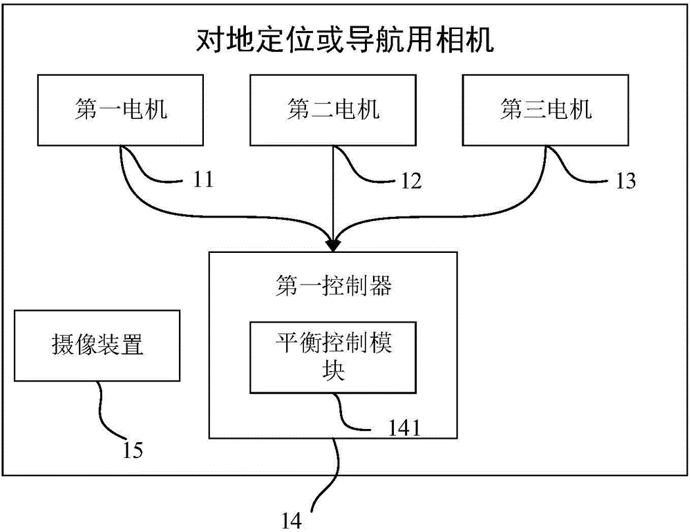
[0051] The camera for ground positioning or navigation with gimbal stabilization in this embodiment includes an imaging device and a gimbal stabilization system. The camera direction of the camera device is vertically downward. The pan-tilt stabilization system includes a pan-tilt main body and a pan-tilt control system, and the pan-tilt control system is connected to the pan-tilt main body. The camera device is arranged on the main body of the pan-tilt.

[0052] Wherein, described PTZ control system, such as figure 1 As shown, it includes a first controller 14 , a first motor 11 , a second motor 12 and a third motor 13 . The first motor 11 , the second motor 12 and the third motor 13 are used to respectively control the rotation of the pan-tilt main body in the three axes of the three-dimensional coordinate system. camera device. The first controller 14 includes a balance control module 141, the balance control module 141 is electrically connected to the first motor 11, t...


PUM


Abstract

The invention discloses a geo-location or navigation type camera, an aircraft, a navigation method thereof and a navigation system thereof. The geo-location or navigation type camera comprises an imaging device. The shooting direction of the imaging device is vertically downward. The camera also comprises a holder stabilizing system. The holder stabilizing system comprises a holder main body and a holder control system. The holder control system is connected with the holder main body. The imaging device is arranged on the holder main body. According to the invention, the holder stabilizing system has the balance control and shock absorption function, so that the stability of the imaging device is better. Meanwhile, the imaging direction of the imaging device is kept vertically downward all the time. Therefore, the navigation can be carried out without the GPS. Moreover, the advantages of high accuracy and wide application range are realized.

Description

technical field [0001] The invention relates to the field of aircraft navigation, in particular to a camera for ground positioning or navigation, an aircraft and a navigation method and system thereof. Background technique [0002] In the prior art, some aircrafts are provided with cameras for taking ground images, but generally the cameras are provided on the aircraft. In this case, since the flight attitude of the aircraft will tilt and shake during flight, the change of the flight attitude will easily cause the camera lens to not always point to the ground, so imaging compensation is required. In order to obtain a better imaging effect, the existing technology generally uses the combined effect of computer calculation compensation and sensor viewing angle compensation to compensate for imaging problems. However, the use of such multiple compensation methods will greatly increase imaging errors, which is not very good It is beneficial to the subsequent application and cal...

Claims


Application Information

Patent Timeline
Patent Type & Authority Applications(China)
IPC IPC(8): G05D3/12
Inventor 田瑜江文彥
Owner YUNEEC TECH CO LTD
Features
  • R&D
  • Intellectual Property
  • Life Sciences
  • Materials
  • Tech Scout
  • Unparalleled Data Quality
  • Higher Quality Content
  • 60% Fewer Hallucinations
Learn More