Slope farmland extracting method and system based on high-resolution remote sensing image

A remote sensing image, high-resolution technology, applied in image enhancement, image analysis, image data processing, etc., can solve problems such as poor flatness, unfavorable farming, and restricting crop yields in dryland

Active Publication Date: 2017-02-08
水利部水土保持监测中心 +1
View PDF5 Cites 42 Cited by
  • Summary
  • Abstract
  • Description
  • Claims
  • Application Information

AI Technical Summary

Problems solved by technology

Due to the poor flatness of sloping cultivated land, it is not conducive to farming, and the problem of running water, fertilizer and soil is prominent, which seriously restricts the increase of crop yield in dry land

Method used


Image

  • Slope farmland extracting method and system based on high-resolution remote sensing image
  • Slope farmland extracting method and system based on high-resolution remote sensing image
  • Slope farmland extracting method and system based on high-resolution remote sensing image

Examples


Embodiment 1

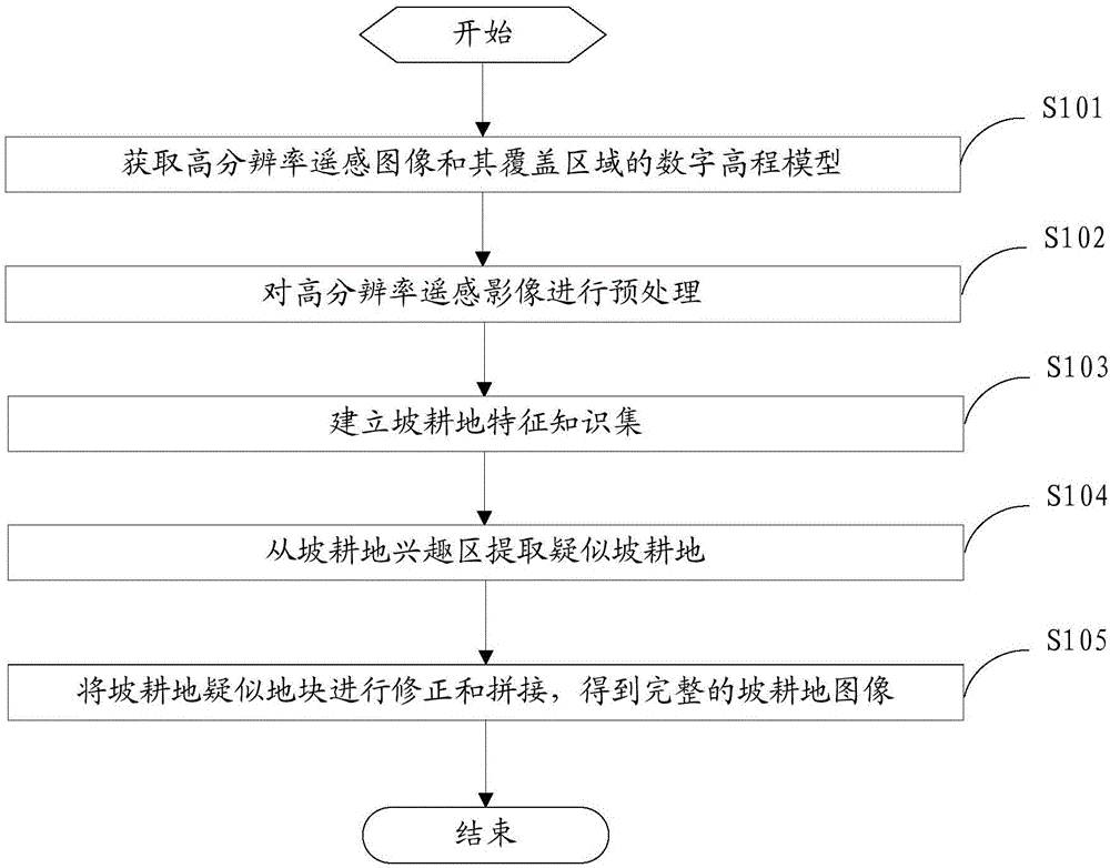
[0054] figure 1 It is a flow chart of steps in an embodiment of a method for extracting slope cultivated land based on high-resolution remote sensing images of the present invention.

[0055] refer to figure 1 As shown, the slope farmland extraction method provided in this embodiment is used to extract slope farmland based on pre-obtained high-resolution remote sensing images, and specifically includes steps:

[0056] S101: Obtain a high-resolution remote sensing image and a digital elevation model of its coverage area.

[0057] High-resolution remote sensing images are not limited to High-Resolution-1, High-Resolution-2, and other similar satellite data sources. Among them, similar satellite data sources need to have both multi-spectral bands and panchromatic bands. Panchromatic bands have a spatial resolution better than 2 meters, and multi-spectral bands have at least blue, green, red, and near-infrared bands.

[0058] Digital elevation model (DEM) refers to the realizat...

Embodiment 2

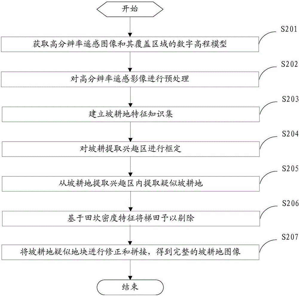
[0089] figure 2 It is a flow chart of the steps of another embodiment of the method for extracting slope cultivated land based on high-resolution remote sensing images of the present invention.

[0090] refer to figure 2 As shown, the slope farmland extraction method provided in this embodiment is used to extract slope farmland based on pre-obtained high-resolution remote sensing images, and specifically includes steps:

[0091] S201: Obtain a high-resolution remote sensing image and a digital elevation model of its coverage area.

[0092] High-resolution remote sensing images are not limited to High-Resolution-1, High-Resolution-2, and other similar satellite data sources. Among them, similar satellite data sources need to have both multi-spectral bands and panchromatic bands. Panchromatic bands have a spatial resolution better than 2 meters, and multi-spectral bands have at least blue, green, red, and near-infrared bands.

[0093] Digital elevation model (DEM) refers to...

Embodiment 3

[0169] image 3 It is a structural block diagram of an embodiment of a system for extracting slope cultivated land based on high-resolution remote sensing images of the present invention.

[0170] refer to image 3 As shown, the slope farmland extraction system provided in this embodiment is used to extract slope farmland according to pre-obtained high-resolution remote sensing images, and specifically includes a data acquisition module 10, a data preprocessing module 20, a feature knowledge set establishment module 30, a suspected Block extraction module 40 and correction stitching module 50 .

[0171] The data acquisition module 10 is used to acquire high-resolution remote sensing images and digital elevation models of their covered areas.

[0172] High-resolution remote sensing images are not limited to High-Resolution-1, High-Resolution-2, and other similar satellite data sources. Among them, similar satellite data sources need to have both multi-spectral bands and panc...


PUM


Abstract

The invention provides a slope farmland extracting method and system based on a high-resolution remote sensing image. According to the extracting method and system, the high-resolution remote sensing image as well as a digital elevation model of a coverage area of the high-resolution remote sensing image is obtained; the high-resolution remote sensing image is pre-processed to remove errors and deformation and establish a high-definition remote sensing image within the area scope; a slope farmland characteristic knowledge set is established according to the high-definition remote sensing image, a field investigation result and a historical research result, the slope farmland characteristic knowledge set comprises description content reflecting a first type of slope farmland in which crops grow well and description content reflecting a second type of slope farmland in a bare area or an area in the seedling stage; a region of interest is extracted and identified from the slope farmland according to the slope farmland characteristic knowledge set, and a suspected land of the slope farmland is extracted; and the suspected land of the slope farmland is corrected and spliced to obtain a complete slope farmland image. Support is thus provided for decision of related governmental departments.

Description

technical field [0001] The invention relates to the technical fields of comprehensive control of water and soil conservation and national land survey, in particular to a method and system for extracting sloping cultivated land based on high-resolution remote sensing images. Background technique [0002] Slope cultivated land, also known as slope cultivated land, refers to the cultivated land distributed on the slopes of mountainous and hilly areas, with poor ground flatness, prominent running water, fertilizer and soil, and low crop yield. Its landform features are generally slopes with a slope between 6° and 25°. Slopes with a slope of less than 6° can be regarded as flat land, while cultivated land with a steep slope of more than 25° should be gradually returned to forests. It is no longer used as a slope. arable land. Due to the poor flatness of sloping cultivated land, it is not conducive to farming, and the problem of running water, fertilizer and soil is prominent, wh...

Claims


Application Information

Patent Timeline
Patent Type & Authority Applications(China)
IPC IPC(8): G06K9/00G06K9/32G06T5/00G06T7/11G06T3/40
CPCG06T3/4038G06T5/001G06T2207/10032G06T2207/30181G06V20/13G06V10/25
Inventor 姜德文罗志东李智广赵院孙娜张金金刘二佳康芮冯阳
Owner 水利部水土保持监测中心
Why Eureka
Try Eureka