Route planning method based on road chain

A road link and path technology, applied in the field of path planning, can solve the problems of inconsistent road perceptual knowledge, reduced algorithm operation efficiency, poor road continuity, etc., to achieve the effect of convenience and speed, reduction of trivialities, and reduction of turning points.

Active Publication Date: 2017-02-22
XIDIAN UNIV
View PDF3 Cites 8 Cited by
  • Summary
  • Abstract
  • Description
  • Claims
  • Application Information

AI Technical Summary

Problems solved by technology

[0005] The Dijkstra algorithm and the A* algorithm are based on the "node-arc" model. Each road is segmented into many arc segments by nodes, and the road network data is trivial. Each search step needs to access a large number of node and arc segment information, and the search space is large. , the amount of calculation increases, and the efficiency of the algorithm decreases
Secondly, the Dijkstra algorithm and the A* algorithm have high accuracy in path planning, but the road continuity is poor and the number of corners is large, which does not conform to people's perceptual understanding of the road.

Method used


Image

  • Route planning method based on road chain
  • Route planning method based on road chain
  • Route planning method based on road chain

Examples


Embodiment Construction

[0025] Combine below figure 1 The present invention is further described:

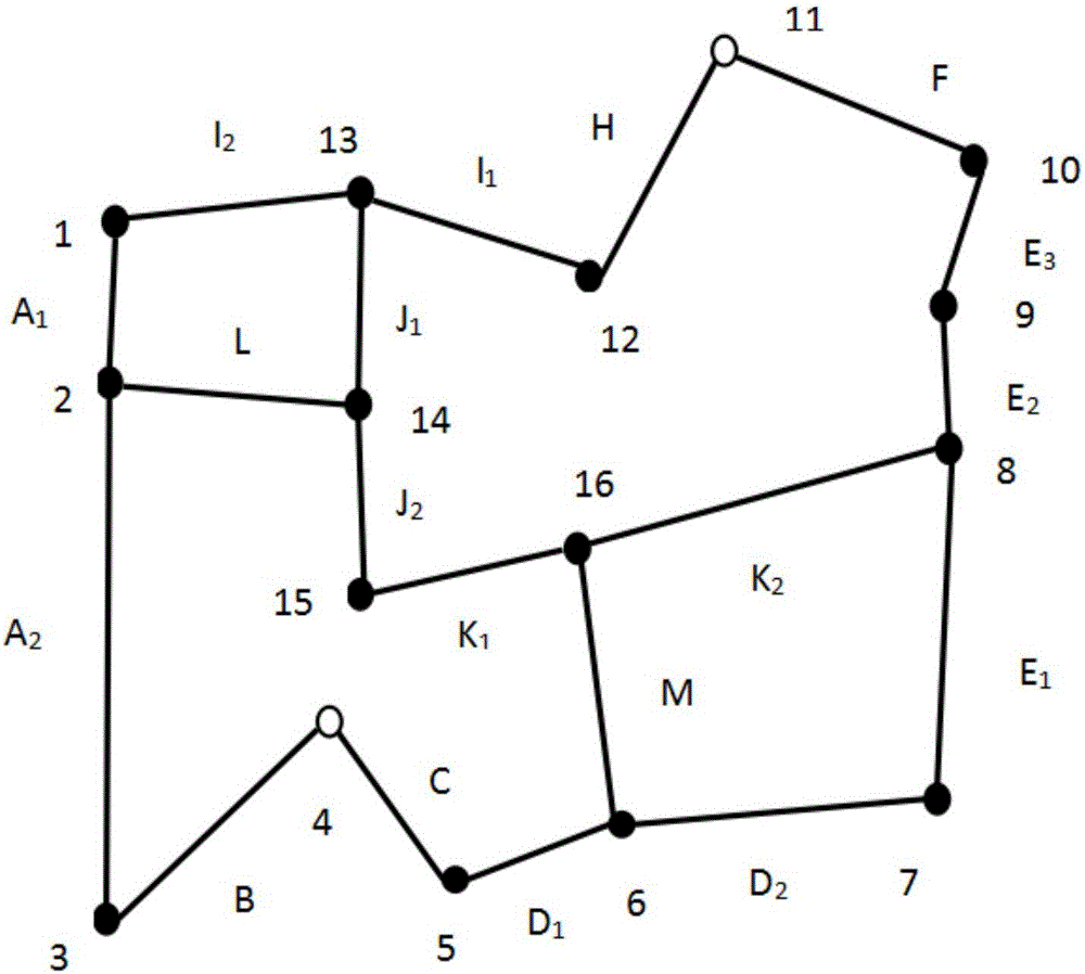
[0026] refer to figure 1 , in the schematic diagram of the scene in the specific embodiment of the present invention, the dots represent the nodes in the road network, numbered with 1-16 respectively, and the black straight lines represent the arcs in the road network, respectively represented by A 1 -M number, hollow dot 11 represents the end point, and hollow dot 4 represents the starting point.

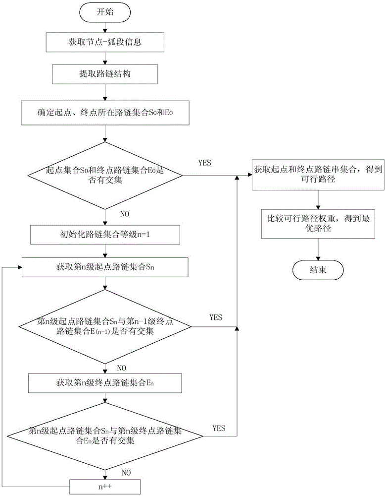
[0027] refer to figure 2 , the implementation steps of the present invention are as follows:

[0028] Step 1. Obtain node-arc information, and use node-arc information to extract link information.

[0029] 1.1) Obtain road network node-arc information:

[0030] 1.11) Extract point elements in the road network as junctions, and extract line elements as edges;

[0031] 1.12) According to the edge-edge connectivity strategy, junction-edge connectivity strategy, and elevation field usage rules, establish...


PUM


Abstract

The invention discloses a route planning method based on a road chain, and mainly solves the problems of long search time and many route corners of the existing route planning method. The method adopts the scheme that the method comprises the following steps: extracting node-arc section information of a road network, obtaining relevance between nodes, between the nodes and arc sections as well as between the arc sections, extracting the road chain meeting road consistency by using the node-arc section information, obtaining feasible routes from an origin to a destination by using a bidirectional search route planning method according to road chain information, origin and destination positions input by a navigation system, and selecting the optimal route from origin to the destination by comparing weights of the feasible routes. The method shortens the route search time, reduces the frequency of the route corners, and can be used for traffic control, resource allocation and vehicle navigation, and the obtained route keeps the road consistency.

Description

technical field [0001] The invention belongs to the technical field of navigation, and in particular relates to a route planning method, which can be used in traffic control, resource allocation and vehicle navigation. Background technique [0002] Path planning refers to finding a collision-free path from the initial state to the goal state in an environment with obstacles according to certain evaluation criteria. The path planning problem can be abstracted into the shortest path search problem in graph theory, that is, the problem of solving the optimal path of a weighted directed graph in graph theory. In traffic control, resource allocation, vehicle navigation and other fields, the shortest path algorithm has increasingly become a research hotspot. [0003] In terms of path planning, many scholars have proposed a series of planning methods to solve the maximum benefit from the starting point to the end point, among which the more classic ones are the path planning based...

Claims


Application Information

Patent Timeline
Patent Type & Authority Applications(China)
IPC IPC(8): G01C21/34
CPCG01C21/3446
Inventor 付少忠孙彦梅宋一博李晓炎刘刚葛建华刘肖莹漆维正
Owner XIDIAN UNIV
Why Eureka
Try Eureka