Urban geographic information processing method

An information processing method and urban technology, applied in geographic information databases, electronic digital data processing, special data processing applications, etc., can solve the lack of a unified project management platform for urban investment projects, the inability to intuitively understand customer investment projects, and investment personnel Problems such as inability to attract investment project management, to achieve the effect of improving input efficiency and accuracy, facilitating timely grasp, and improving user experience

Inactive Publication Date: 2017-03-15
青岛城市大脑投资开发股份有限公司
View PDF5 Cites 2 Cited by
  • Summary
  • Abstract
  • Description
  • Claims
  • Application Information

AI Technical Summary

Problems solved by technology

[0002] Existing urban investment promotion projects lack a unified project management platform, resulting in the inability of investment personnel to effectively manage specific investment promotion projects in the city; in addition, because existing investment promotion projects are often presented in the form of text and tables, customers are unable to In the face of specific investment projects, it is impossible to have an intuitive understanding, and it is difficult to track projects
In addition, the investment promotion personnel are currently unable to update the progress of specific investment promotion projects in a timely and effective manner, which affects the investment promotion process

Method used


Image

  • Urban geographic information processing method

Examples


Embodiment 1

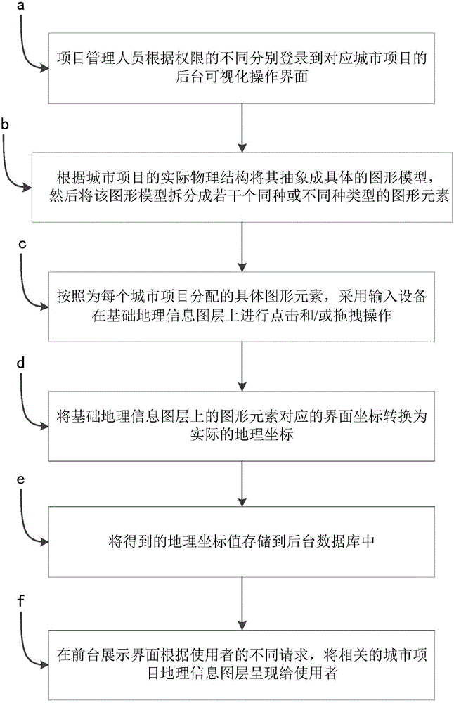
[0028] Such as figure 1 As shown, a method for processing urban geographic information includes the following steps:

[0029] aProject management personnel log in to the background visual operation interface of the corresponding city project according to different permissions. The basic geographic information layer is displayed on the background visual operation interface.

[0030] The basic geographic information layer can be provided by a third-party platform, such as Baidu Map, Google Map, Sogou Map, etc.

[0031] Urban projects in the present invention include but not limited to urban building construction, road planning and construction, and bottom line pipeline (such as sewer, gas pipeline, power grid, etc.) layout planning and construction.

[0032] bAccording to the actual physical structure of the urban project, abstract it into a specific graphic model, and then split the graphic model into several graphic elements of the same or different types. The representatio...

Embodiment 2

[0072] Embodiment 2 is different from Embodiment 1 except for the following technical features, and other technical features can refer to Embodiment 1.

[0073] In step c of Embodiment 1, after the entry of geographic information of the urban project is completed, the progress corresponding to the urban project is entered, that is, corresponding to each process of the life cycle of the urban project.

[0074] Each process of the life cycle of each urban project is not exactly the same. For example:

[0075] To build a building, its life cycle can be divided into "project site selection", "land certificate approval completion", "land leveling", "building foundation", "infrastructure laying", "main body completion", "exterior wall coating" and "Project Completion".

[0076] Of course, its life cycle can also be divided into "starting", "under construction" and "construction completed".

[0077] The division of the life cycle of each urban project depends on the grasp of the p...

Embodiment 3

[0080] Embodiment 3 is different from Embodiment 1 or Embodiment 2 in terms of the following technical features, and other technical features can refer to Embodiment 1 or Embodiment 2.

[0081] In step f of Embodiment 1 or 2, the urban project geographic information layer adopts map tile technology for layer display.

[0082] In a geographical information layer of an urban project that has been entered, if the layer is too large and contains too much information, due to the limitation of network bandwidth, it will take a long time to load during the loading process, the user experience is poor, and the map tile function Then the whole layer is divided into several small layers. In the process of network loading, according to the advantages of http multi-threaded resource download, at the same time, multiple pieces of fragmented map resources are requested, and they are flattened and restored to a complete layer on the display page. .

[0083] Specifically, the specific proces...


PUM


Abstract

The invention discloses an urban geographic information processing method which comprises the following steps that a, a project management worker logs in a background visualized interface of a corresponding urban project; b, the urban project is abstracted into a specific graphic model according to the actual physical structure of the urban project, and then the graphic model is split into a plurality of same or different types of graphic elements; c, according to the specific graphic elements allocated for respective urban projects, an input device carries out click and/or drag operation on a basic geographic information layer in order to achieve the urban project geographic information input; d, interface coordinates corresponding to the graphic elements on the basic geographic information layer are converted into actual geographical coordinates; e, the geographical coordinates acquired in the step d are stored in a background database; and f, the relevant urban project geographic information layer is presented to the user in a foreground display interface according to different user requests,. The urban geographic information processing method realizes the organic combination of the ubran project and the geographic information service.

Description

technical field [0001] The invention relates to a method for processing urban geographic information. Background technique [0002] Existing urban investment promotion projects lack a unified project management platform, resulting in the inability of investment personnel to effectively manage specific investment promotion projects in the city; in addition, because existing investment promotion projects are often presented in the form of text and tables, customers are unable to In the face of specific investment projects, it is impossible to have an intuitive understanding, and it is difficult to track the projects. In addition, the investment promotion personnel are currently unable to update the progress of specific investment promotion projects in a timely and effective manner, which affects the investment promotion process. Therefore, how to uniformly and effectively manage urban investment projects has become the focus of research by those skilled in the art. Contents...

Claims


Application Information

Patent Timeline
Patent Type & Authority Applications(China)
IPC IPC(8): G06Q30/02G06F17/30
CPCG06Q30/0201G06F16/29
Inventor 邰鑫月刘寅虎陆运全谢永强武云刚
Owner 青岛城市大脑投资开发股份有限公司
Why Eureka
Try Eureka