Analytical Astronomical Positioning Method Projected to Equinox Equatorial Coordinate System
A technology of astronomical positioning and vernal equinox, which is applied in astronomical navigation, navigation calculation tools, etc., can solve the problems of increasing the amount of calculation, etc., and achieve the effect of simple calculation and real-time calculation of astronomical positioning
- Summary
- Abstract
- Description
- Claims
- Application Information
AI Technical Summary
Problems solved by technology
Method used
Image
Examples
specific Embodiment approach 1
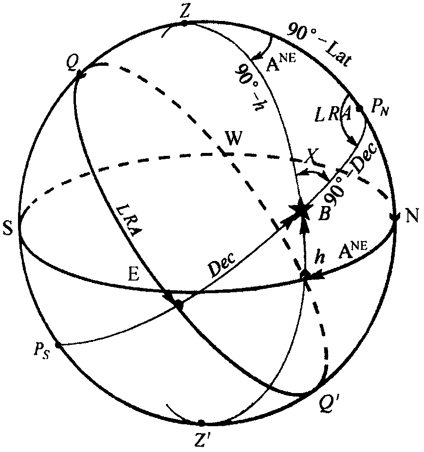
[0034] Specific embodiment 1, observe the true azimuth A and true height h of the unknown celestial body B at the known position Z (Lat / Long), and calculate the position of the celestial body; obtain the right ascension GRA of the Green point according to the time, and project the position Z of the observer to the vernal equinox Equatorial coordinate system In the astronomical triangle, such as figure 1 Shown: Given the three elements of top distance (90°-h), cosine latitude (90°-Lat) and azimuth A, use the cosine formula to solve the residual distance (90°-Dec):
[0035] cos(90°-Dec)=cos(90°-h)*cos(90°-Lat)
[0036] +sin(90°-h)*sin(90°-Lat)*cos(A)
[0037] =sin(h)*sin(Lat)+cos(h)*cos(Lat)*cos(A)
[0038] Solve the residual distance (90°-Dec), and get the declination Dec of the celestial body; then use the cosine formula to deform and solve the local right ascension LRA:
[0039]
[0040] Calculate the local right ascension LRA and get the celestial right ascension RA=LR...
specific Embodiment approach 2
[0041] Specific embodiment 2, observe the true azimuth A and the true altitude h of the known celestial body B (Dec / RA) at the unknown position Z, and calculate the position of the measurer; obtain the right ascension of the Green point GRA according to the time, and project the position Z of the measurer to The equinox equatorial coordinate system, in the astronomical triangle, such as figure 1 Shown: Knowing the three elements of residual distance (90°-Dec), top distance (90°-h) and azimuth A, use the sine formula to solve the local right ascension LRA:
[0042]
[0043] Solve the local right ascension LRA, get the longitude Long=RA-LRA-GRA; then use Napier's formula deformation to solve the co-latitude (90°-Lat):
[0044]
[0045] The co-latitude (90°-Lat) is obtained through the calculation, and the latitude Lat is obtained; the position (Lat, Long) of the tester is obtained.
specific Embodiment approach 3
[0046] Specific embodiment 3, observe a known celestial body B (Dec / RA) at a known position Z (Lat / Long), and calculate the true azimuth A and true height h of the celestial body; obtain the right ascension GRA of the Green point according to the time, and measure the position Z projection to equinox equatorial coordinate system From the celestial right ascension RA and the observer's right ascension RA Z Get local right ascension LRA=RA-RA Z , in the astronomical triangle, such as figure 1 Shown: Given the three elements of margin (90°-Dec), co-latitude (90°-Lat) and local right ascension LRA, use the cosine formula to solve the top distance (90°-h):
[0047] cos(90°-h)=cos(90°-Dec)*cos(90°-Lat)
[0048] +sin(90°-Dec)*sin(90°-Lat)*cos(LRA)
[0049] =sin(Dec)*sin(Lat)+cos(Dec)*cos(Lat)*cos(LRA)
[0050] Solve the top distance (90°-h) and get the height h; then use the cosine formula to deform and solve the azimuth A:
[0051]
[0052] The azimuth A is obtained throug...
PUM
 Abstract
Description
Claims
Application Information
 - R&D
- Intellectual Property
- Life Sciences
- Materials
- Tech Scout
- Unparalleled Data Quality
- Higher Quality Content
- 60% Fewer Hallucinations
Browse by: Latest US Patents, China's latest patents, Technical Efficacy Thesaurus, Application Domain, Technology Topic, Popular Technical Reports.
© 2025 PatSnap. All rights reserved.Legal|Privacy policy|Modern Slavery Act Transparency Statement|Sitemap|About US| Contact US: help@patsnap.com


