Method of identifying urban function area integrated with population density and landscape structure

A technology of urban function and population density, applied in character and pattern recognition, instruments, computer parts, etc., can solve problems such as less research on functional division boundaries

Active Publication Date: 2017-03-22
INST OF URBAN ENVIRONMENT CHINESE ACAD OF SCI
View PDF4 Cites 5 Cited by
  • Summary
  • Abstract
  • Description
  • Claims
  • Application Information

AI Technical Summary

Problems solved by technology

At present, land use data are mostly used to distinguish urban built-up areas from non-built-up areas, and there are few studies on the boundaries between these functional divisions
[0003] In addition, the research on the internal functional pattern...

Method used


Image

  • Method of identifying urban function area integrated with population density and landscape structure
  • Method of identifying urban function area integrated with population density and landscape structure
  • Method of identifying urban function area integrated with population density and landscape structure

Examples


Embodiment Construction

[0032] A method of urban functional zoning based on population density and landscape structure of the present invention can be illustrated by the following examples:

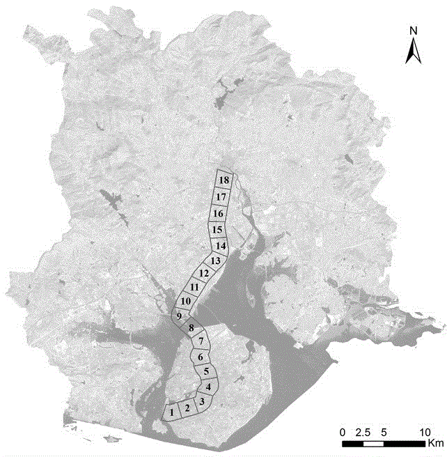
[0033] a. The present invention selects Xiamen City as the implementation case city, and makes a buffer zone with a radius of 1km along the urban expansion axis (Xiahe Road-Jiahe Road-Xiamen Bridge-Tongji South Road-Tongji Road-Tongji North Road) as a sample square, The first point is arranged at the starting point of Xiahe Road, and then points are arranged every 2km, and a vertical line is used to divide the buffer zone through the point, which is divided into 17 quadrats in turn. The result is as figure 1 .

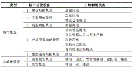
[0034] b. Classify the urban functional landscape based on land use, the results are as follows figure 2 .

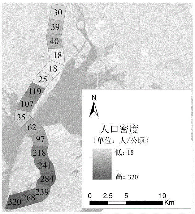
[0035] c. Calculate the population density of the quadrat

[0036] Based on the population data and area of ​​each administrative village in Xiamen City, the population density of each admini...


PUM


Abstract

The invention relates to a method of identifying an urban function area integrated with population density and landscape structure. For the method of identifying an urban function area integrated with population density and landscape structure, the used data is mainly the village-level population statistical data and the land utilization data. The processing process of the method of identifying an urban function area integrated with population density and landscape structure includes the steps: a, selecting a typical road as an urban expansion axis and setting a sampling band and a quadrat; b, extracting the population density and land utilization type information of the quadrat; and c, integrating population density with landscape structure to identify an urban function area, such as an urban center area, a peripheral area and an outer suburban district. Based on the relation between urban land utilization and the landscape function, the method of identifying an urban function area integrated with population density and landscape structure can identify the urban function area by calculating the population density and an urban landscape index, thus being helpful for scientifically learning about the internal structure of a city, and promoting reasonable planning and functional configuration of the city.

Description

technical field [0001] The method belongs to the cross technical field of landscape ecology, urban geography and geographic information technology. Background technique [0002] Along with the process of urbanization, different urban functional divisions will inevitably appear along the urban expansion axis, such as urban central area, peripheral area, (isolation zone), (satellite city), and outer suburbs. At present, land use data are mostly used to distinguish urban built-up areas from non-built-up areas, and there are few studies on the boundaries between these functional divisions. [0003] In addition, the research on the internal functional pattern of the city mainly analyzes the characteristics of the functional division of labor within the city by using the population of each district and county by industry or related socio-economic indicators, and seldom studies it from the perspective of landscape. There are relatively few studies on the application of integrated ...

Claims


Application Information

Patent Timeline
IPC IPC(8): G06K9/62
CPCG06F18/232
Inventor 吝涛孙彩歌李新虎宋金超张国钦赵宇叶红葛如冰刘晓芳
Owner INST OF URBAN ENVIRONMENT CHINESE ACAD OF SCI
Why Eureka
Try Eureka