A quantitative method for influences on a GPS coordinate time series by a higher-order item ionospheric delay

A technology of coordinate time series and ionospheric delay, applied in radio wave measurement system, satellite radio beacon positioning system, measurement device, etc., can solve problems such as quantitative influence to be studied

Active Publication Date: 2017-05-31
WUHAN UNIV
View PDF6 Cites 8 Cited by
  • Summary
  • Abstract
  • Description
  • Claims
  • Application Information

AI Technical Summary

Problems solved by technology

However, based on long-term coordinate time series, the quantitative impact of high-order ionospher

Method used


Image

  • A quantitative method for influences on a GPS coordinate time series by a higher-order item ionospheric delay
  • A quantitative method for influences on a GPS coordinate time series by a higher-order item ionospheric delay
  • A quantitative method for influences on a GPS coordinate time series by a higher-order item ionospheric delay

Examples


Embodiment

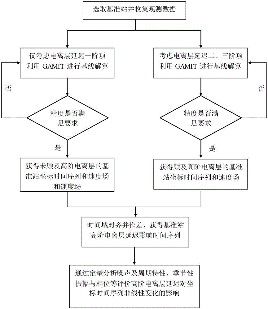
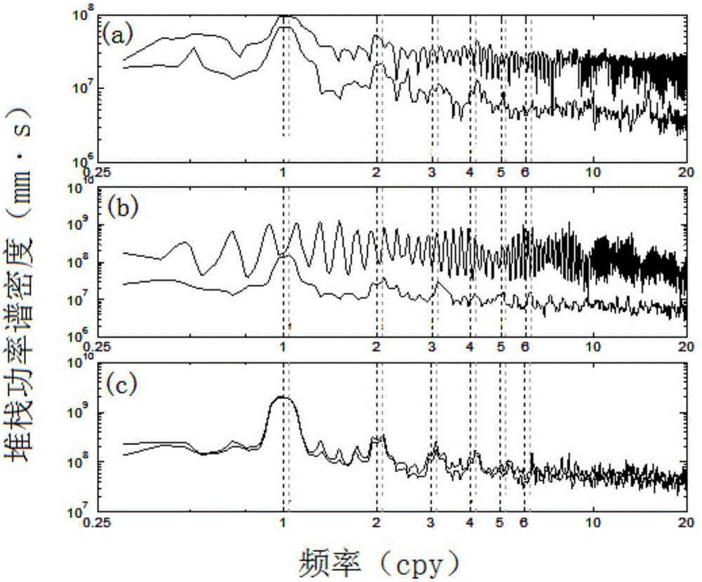
[0086] The method of the present invention is used to quantitatively determine the impact time series of the high-order ionospheric delay of 104 globally distributed IGS reference stations, and the difference between the periodic characteristics and noise characteristics of the GPS coordinate time series before and after adding the high-order ionosphere correction is analyzed, and finally its Effects on the coordinate reference frame implementation.

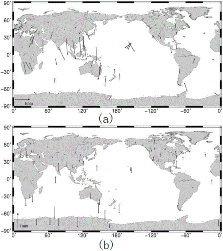
[0087] First, the influence of the high-order item of ionospheric delay on the coordinates of the IGS reference station is given quantitatively, see figure 2 . The analysis results show that in the plane direction, the high-latitude stations have a tendency to deviate northward, while the equatorial stations move southward, and the offset value near the equator is greater than that of other latitudes; from the perspective of elevation changes, the northern hemisphere The elevation of most stations increases, while the elevation ...


PUM


Abstract

The invention discloses a quantitative method for influences on a GPS coordinate time series by a higher-order item ionospheric delay. The method comprises the steps of collecting original observation data of a GPS base station; obtaining a GPS coordinate time series considering only the first order term of the ionospheric delay based on the historical observation data and recording the GPS coordinate series as sequence A; calculating the GPS coordinate time series corrected by the ionospheric high order term based on the historical observation data and recording the series as sequence B; aligning the series A and the series B in a time domain and subtracting the series A and the series B to obtain a high-order term ionospheric delay influence time series of the GPS base station and recording the series as sequence C; and separately subjecting the sequence A, sequence B and sequence C to noise analysis to obtain the observation station speed, noise characteristics and seasonal information corresponding to each sequence so as to quantify the influence of the high-order term ionospheric delay. The quantitative method of the invention can quantitatively determine the influence of the high-order ionospheric delay on the observation station coordinate time series, and can better explain the non-linear variation source presented in the GPS coordinate time series.

Description

technical field [0001] The invention belongs to the technical field of nonlinear time series analysis, and specifically relates to a quantification method for the influence of high-order item ionospheric delay on GPS coordinate time series. Background technique [0002] In addition to the linear trend caused by the plate tectonic movement where the station is located, there are also significant nonlinear changes in the GPS coordinate time series, mainly manifested as seasonal fluctuations. These nonlinear changes mainly include three types: (1) False nonlinear changes caused by some unmodeled factors during GPS data processing, including high-order ionospheric delays, unmodeled ocean tidal components, and S1-S2 atmospheric tides etc.; (2) The true nonlinear motion of the station reference point caused by geophysical effects, including atmospheric loads, non-tidal ocean loads, hydrological loads, thermal expansion effects, etc.; (3) Observational noise. Improving the GPS pre...

Claims


Application Information

Patent Timeline
IPC IPC(8): G01S19/07G01S19/44
CPCG01S19/07G01S19/44
Inventor 姜卫平王锴华邓连生李昭陈华马俊马一方
Owner WUHAN UNIV
Why Eureka
Try Eureka