Method and system of land cover verification considering POI data spatial heterogeneity

A technology of spatial heterogeneity and land cover, applied in the directions of instruments, character and pattern recognition, scene recognition, etc., can solve the problems of sparse distribution, inability to verify land cover, difficult POI land cover, etc.

Active Publication Date: 2017-06-13
SHANDONG NORMAL UNIV
View PDF4 Cites 16 Cited by
  • Summary
  • Abstract
  • Description
  • Claims
  • Application Information

AI Technical Summary

Problems solved by technology

However, applying POI data to land cover verification still faces many challenges: on the one hand, some POI types such as "unknown classification", "tourist attractions" and "entertainment venues" cannot directly determine the type of land cover, and POI data needs to be Cleaning and classification;

Method used


Image

  • Method and system of land cover verification considering POI data spatial heterogeneity
  • Method and system of land cover verification considering POI data spatial heterogeneity
  • Method and system of land cover verification considering POI data spatial heterogeneity

Examples


Embodiment Construction

[0084] The present invention will be further described below in conjunction with the accompanying drawings and embodiments.

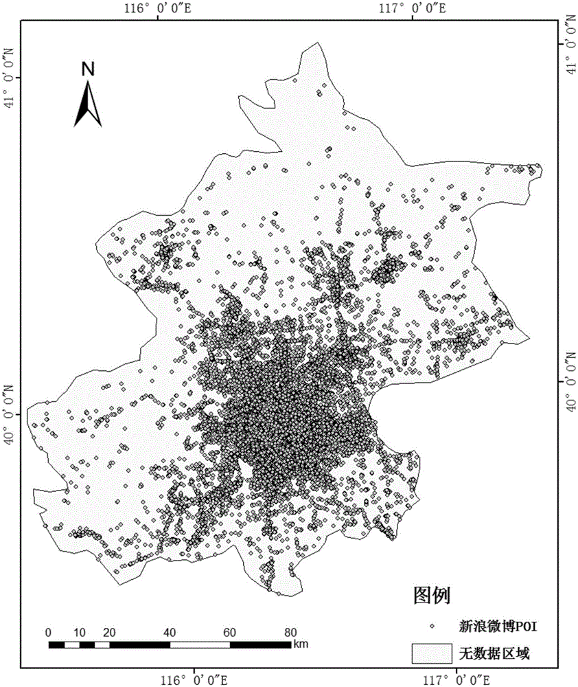
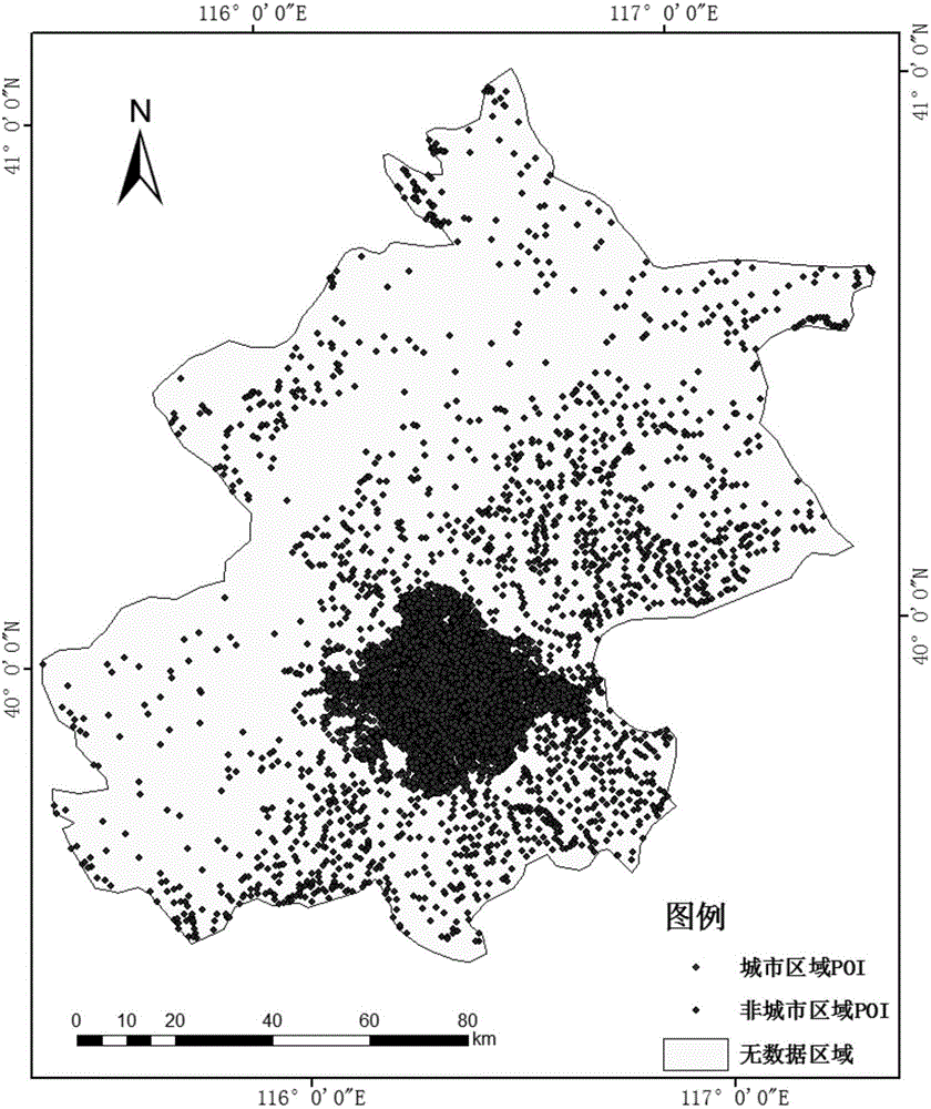
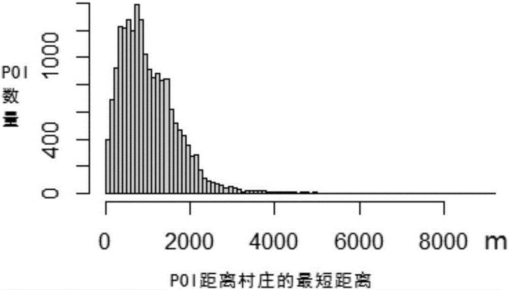
[0085] In order to have a clearer understanding of the technical features, purposes and effects of the present invention, the specific implementation of the present invention will be described with reference to the accompanying drawings by taking the Sina Weibo POI data and GlobeLand30 surface coverage data in the Beijing area as examples.

[0086] The following will clearly and completely describe the technical solutions in the embodiments of the present invention with reference to the accompanying drawings in the embodiments of the present invention. Obviously, the described embodiments are only some, not all, embodiments of the present invention.

[0087] A land cover verification method that takes into account the spatial heterogeneity of POI data proposed by the present invention, the method is used for POI-based land cover verification; the land co...


PUM


Abstract

The present invention discloses a method and system of land cover verification considering POI (Point of Interest) data spatial heterogeneity. The method comprises: obtaining a POI data set from a Sina Weibo open platform, performing overlapping o the urban area building data provided by an OSM (Open Street Map) and the POI data set, dividing POIs of an urban region and a non-urban region, and correcting a division result; classifying the determined urban region POI, and obtaining the POI classification result of the urban region; classifying different types of POIs of the non-urban region, and obtaining the POI classification result of the non-urban region; generating grid data according to the POI classification result, employing a majority voting algorithm to determine the land cover model of each grid, and generating a land cover classification result based on the POI; and employing a confusion matrix to obtain the verification precision of GlobeLand30 land cover data products based on the POI, and realizing the land cover precision verification considering POI spatial heterogeneity.

Description

technical field [0001] The invention relates to a land cover verification method and system taking into account the spatial heterogeneity of POI data. Background technique [0002] Land cover and its change are indispensable and important factors in environmental change research, geographical monitoring and sustainable development planning, and its accuracy verification is an important part of land cover mapping. At present, the verification of land cover classification accuracy at home and abroad is mainly carried out through visual interpretation of remote sensing images and field surveys. In order to reduce the cost of land cover verification and better meet the application needs of users for rapid daily verification, it is necessary to develop a new land cover verification method. [0003] In recent years, with the development and application of geographic spatiotemporal big data, surface coverage product sharing and verification platforms such as Geo-wiki, GlobeLand30,...

Claims


Application Information

Patent Timeline
IPC IPC(8): G06K9/62G06K9/32G06K9/00
CPCG06V20/13G06V20/635G06F18/24
Inventor 邢汉发孟媛陈小祥侯东阳陈志谋吕磊
Owner SHANDONG NORMAL UNIV
Why Eureka
Try Eureka