A targeting and navigation method for remote-controlled ships after GPS loses lock

A technology of positioning navigation and targeting method, applied in the field of navigation, can solve the problems of inertial navigation positioning time drift, incoherent positioning and navigation work, and restrict the flexibility of road sign layout, so as to achieve the effect of improving the recognition rate

Active Publication Date: 2019-07-05
园测信息科技股份有限公司
View PDF3 Cites 0 Cited by
  • Summary
  • Abstract
  • Description
  • Claims
  • Application Information

AI Technical Summary

Problems solved by technology

However, limited by the problem of inertial positioning accuracy drifting over time, it is only effective for GPS intermittently out of lock, and it is difficult to meet the requirements of precise positioning in some special areas where GPS is out of lock for a long time
In addition, in the field of autonomous navigation of outdoor robots, some scholars have also proposed a method for positioning and navigating robots based on panoramic near-infrared landmark recognition algorithms, but this method only solves the problem of relative positioning between robots and landmarks. Absolute positioning can only be performed when the position is known. This mode of operation seriously restricts the flexibility of road sign layout, and the recognition and positioning accuracy of panoramic near-infrared road signs is low, which is difficult to meet the positioning accuracy of measurement-type remote control ships. requirements
[0003] To sum up, before and after the GPS lock of the remote control survey ship, the connection of positioning and navigation work is incoherent; and after the GPS lock is lost, how to conduct long-term continuous and accurate monitoring of the remote control survey ship through freely set targets positioning problem

Method used


Image

  • A targeting and navigation method for remote-controlled ships after GPS loses lock
  • A targeting and navigation method for remote-controlled ships after GPS loses lock
  • A targeting and navigation method for remote-controlled ships after GPS loses lock

Examples


Embodiment Construction

[0018] The preferred embodiments of the present invention will be described in detail below in conjunction with the accompanying drawings, so that the advantages and features of the present invention can be more easily understood by those skilled in the art, so as to define the protection scope of the present invention more clearly.

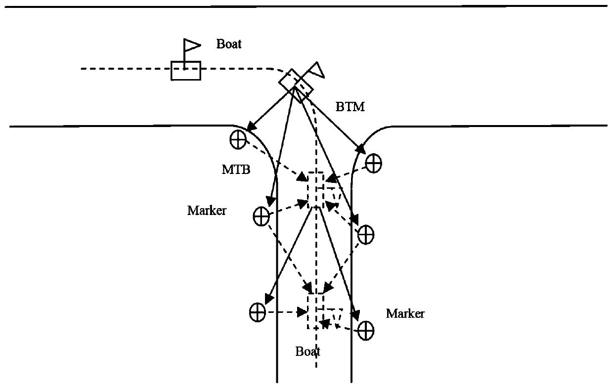
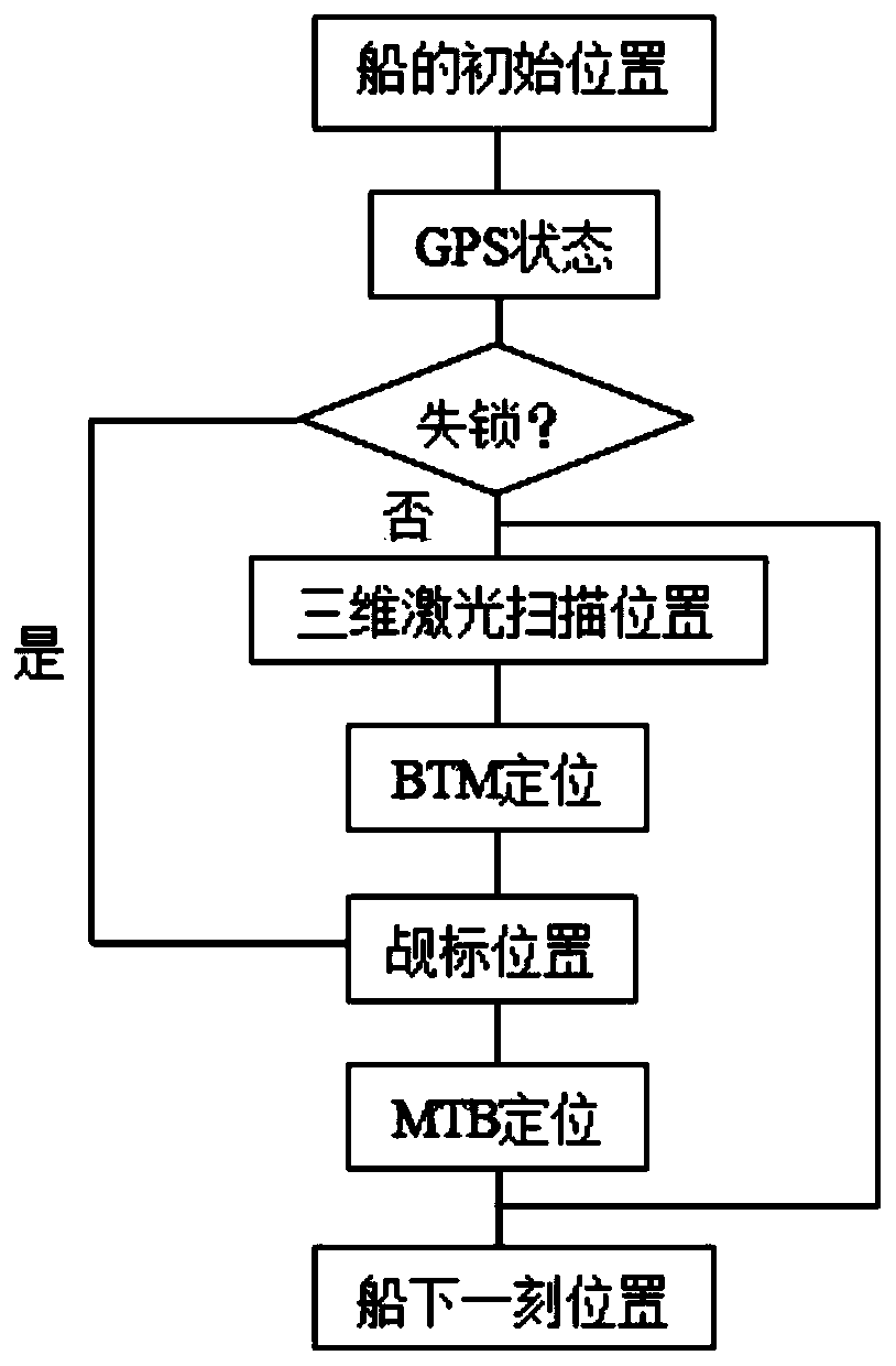
[0019] See attached Figure 1-3 As shown, a kind of target method positioning and navigation method used for remote control ship after GPS loses lock of the present embodiment, its steps are:

[0020] (1). Targets are continuously and freely arranged in areas with severe occlusion on both sides of the river revetment, but it is necessary to ensure that there are at least three targets within the measuring range of the laser scanning equipment when the remote control survey ship enters the area;

[0021] (2). After the target is laid out, the remote-controlled survey ship starts to work. On the river surface with a wide view, that is, when the GPS...


PUM


Abstract

The invention discloses a target positioning and navigation method for a remote control ship after the GPS is out of lock, comprising the following steps: (1). within the measuring range of the laser scanning equipment; (2). In a wide field of view, the positioning and navigation of the remote survey ship is completed by GPS and inertial navigation equipment; Displayed in the measurement system in the form of point cloud; (3). Obtain the initial three-dimensional coordinates through BTM positioning; (4). Continue to move forward. If the three-dimensional coordinates of the target change more than 5 times in a row and are all less than 10cm, take the average value. As the final three-dimensional coordinates of the target; (5). When there are more than three targets with the final three-dimensional coordinates within the measurement range of the laser scanning equipment, the real-time position of the remote control survey ship can be reversely determined by using the targets through the MTB positioning . The present invention can realize accurate positioning in the case of discontinuous and complete GPS out-of-lock.

Description

technical field [0001] The invention relates to a navigation method, in particular to a targeting method positioning and navigation method for a remote control ship after the GPS loses lock. Background technique [0002] At present, the precision positioning method of the remote control survey ship mainly adopts the combined positioning method of GPS and inertial navigation. When the GPS is intermittently lost, the inertial navigation is used to continue to provide position and attitude information for the remote control ship. However, limited by the problem that the accuracy of inertial navigation positioning drifts over time, it is only effective for intermittent GPS out-of-lock situations, and it is difficult to satisfy precise positioning in some special areas where GPS is out of lock for a long time. In addition, in the field of autonomous navigation of outdoor robots, some scholars have also proposed a method for positioning and navigating robots based on panoramic nea...

Claims


Application Information

Patent Timeline
Patent Type & Authority Patents(China)
IPC IPC(8): G01S19/49
CPCG01S19/49
Inventor 甄宗坤蔡东健范占永
Owner 园测信息科技股份有限公司
Why Eureka
Try Eureka