Inclination model and multivariate model dynamic fusion-based adaptive network visualization method

An adaptive network and model technology, applied in the field of geospatial information systems, can solve the problems of difficult to meet the application needs of diverse terminal equipment of different user groups, and achieve the effect of high interactivity

Inactive Publication Date: 2017-06-27
朱庆
View PDF5 Cites 23 Cited by
  • Summary
  • Abstract
  • Description
  • Claims
  • Application Information

AI Technical Summary

Problems solved by technology

[0004] At present, the devices used by users to access the Internet are becoming more and more diversified, including not only mobile phones, computers, but also tablets. However, most of t...

Method used


Image

  • Inclination model and multivariate model dynamic fusion-based adaptive network visualization method
  • Inclination model and multivariate model dynamic fusion-based adaptive network visualization method
  • Inclination model and multivariate model dynamic fusion-based adaptive network visualization method

Examples


Embodiment Construction

[0040] The present invention is described below in conjunction with accompanying drawing:

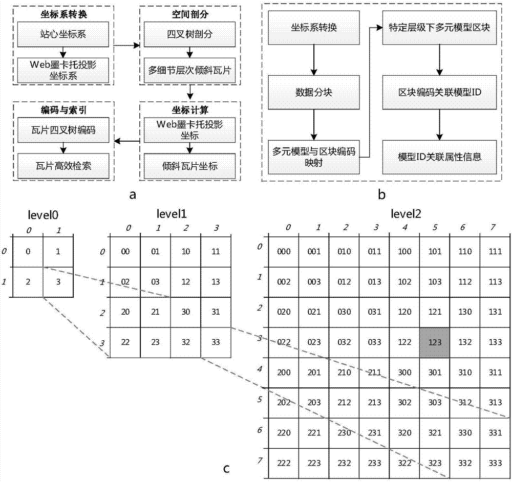
[0041] Such as figure 1 As shown, firstly, the mass tilt model and the multivariate model are optimized to organize,

[0042] S1. Mass tilt model and multivariate model optimization organization, including:

[0043] S11. Tilting the model to optimize the organization, such as figure 1 (a), including:

[0044] S111. Conversion of the tilted model coordinate system, converting the coordinate system of the tilted model from the station center coordinate system to the Web Mercator projection coordinate system. The equiangularity of the Mercator projection will help ensure the uniform granularity of the tile division of the tilted model The specific conversion formula is as follows:

[0045] Among them, pi is the circumference ratio π, Lat is the longitude of the tile, Lng is the latitude of the tile, L refers to the level of detail level, TileWidth refers to the width of a single ti...


PUM


Abstract

The invention belongs to the technical field of a geographic space information system, and particularly relates to an inclination model and multivariate model dynamic fusion-based adaptive network visualization method. According to the inclination model and multivariate model dynamic fusion-based adaptive network visualization method provided by the invention, by performing dynamic fusion operation on an inclination model and a multivariate model, the difficult problem of multi-granularity three-dimensional scene fusion modeling of a local fine independent entity model and a large-range inclination model as data sources is solved; and meanwhile, through efficient massive inclination model and multivariate model organization, scene service release and adaptive visualization, complex three-dimensional scene adaptive visualization display for multiple user terminals in a network environment is realized.

Description

technical field [0001] The invention belongs to the technical field of geospatial information systems, and in particular relates to an adaptive network visualization method for dynamically merging an oblique model and a multivariate model. Background technique [0002] Oblique photogrammetry technology comprehensively perceives complex scenes in a large-scale, high-precision, and high-definition manner, and its data result oblique model provides data and accuracy guarantees for realistic displays in the real world. At the same time, the continuous development of network technology connects independent computer systems distributed in different locations through interconnection channels. The rapid release and visualization of geographic information services in the network environment is conducive to improving the utilization efficiency and sharing degree of spatial data. Therefore, it is of great significance to realize the efficient display and interactive exploration of the ...

Claims


Application Information

Patent Timeline
IPC IPC(8): G06T17/30
CPCG06T17/30
Inventor 朱庆朱军
Owner 朱庆
Why Eureka
Try Eureka