Image segmentation method and system for remote sensing image terrains

A remote sensing image and image segmentation technology, applied in the field of remote sensing image processing, can solve problems such as segmentation of all information images, ineffective use of 3D remote sensing images, etc.

Active Publication Date: 2017-06-30
武汉喜恩卓科技有限责任公司
View PDF4 Cites 11 Cited by
  • Summary
  • Abstract
  • Description
  • Claims
  • Application Information

AI Technical Summary

Problems solved by technology

[0003] The technical problem to be solved by the present invention is: the traditional method only considers two-dimensional data, and only considers the relationship between the color of the coordinate point of the image and the position of the coordinate point in the segmentation process, and cannot effectively use all the information for image segmentation of the three-dimensional remote sensing image

Method used


Image

  • Image segmentation method and system for remote sensing image terrains
  • Image segmentation method and system for remote sensing image terrains
  • Image segmentation method and system for remote sensing image terrains

Examples


Embodiment Construction

[0038] The principles and features of the present invention are described below in conjunction with the accompanying drawings, and the examples given are only used to explain the present invention, and are not intended to limit the scope of the present invention.

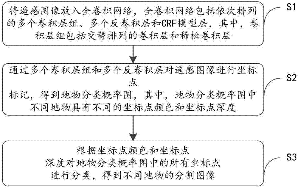
[0039] Such as figure 1 As shown, in an embodiment, a method for image segmentation of remote sensing image features is provided, including:

[0040] S1: Put the remote sensing image into the full convolutional network. The full convolutional network includes multiple convolutional layer groups, multiple deconvolution layers, and CRF model layers arranged in sequence. The convolutional layer groups include alternately arranged convolutional layers. layer and sparse convolutional layer;

[0041] S2: Mark the coordinate points of the remote sensing image through multiple convolutional layer groups and multiple deconvolution layers to obtain the classification probability map of the ground objects, in which different ...


PUM


Abstract

The invention relates to an image segmentation method and system for remote sensing image terrains. The method comprises the following steps: in step S1, remote sensing images are placed in a full convolution network which comprises a plurality of convolution layer groups, a plurality of deconvolution layers and a CRF model layer that are orderly arranged; the convolution layer groups comprise convolution layers and sparse convolution layers that are arranged alternatively; in step S2, the remote sensing images are subjected to coordinate point marking operation via the plurality of convolution layer groups and the plurality of deconvolution layers, a terrain classification probability graph is obtained, and different terrains have different coordinate point colors and coordinate point depths in the terrain classification probability graph; in step S3, all coordinate points in the terrain classification probability graph are classified according to the coordinate point colors and coordinate point depths, and segmented images of different terrains are obtained. The beneficial effects of the image segmentation method and system are that colors and depths of the remote sensing images are added in image identification and segmentation, color information and depth information are analyzed comprehensively, and images can be cut precisely via the CRF model layer.

Description

technical field [0001] The invention relates to the technical field of remote sensing image processing, in particular to an image segmentation method and system for remote sensing image ground objects. Background technique [0002] The edge segmentation of ground objects in remote sensing images is a key technology of geographic information systems, and plays a very important role in the fields of land planning, disaster prevention, unmanned aerial vehicles, satellites, unmanned ships and resource monitoring. The traditional method only considers two-dimensional data, and only considers the relationship between the coordinate point color and coordinate point position of the image in the segmentation process. For three-dimensional remote sensing images, all information cannot be effectively used for image segmentation. Contents of the invention [0003] The technical problem to be solved by the present invention is: the traditional method only considers two-dimensional data...

Claims


Application Information

Patent Timeline
Patent Type & Authority Applications(China)
IPC IPC(8): G06T7/174G06T7/50G06T7/90
CPCG06T2207/10032G06T2207/20081G06T2207/20084G06T2207/20221G06T2207/30181
Inventor 涂刚
Owner 武汉喜恩卓科技有限责任公司
Why Eureka
Try Eureka