
Yangtze river entering sea model

A model, the technology of the Yangtze River Basin, applied in the field of teaching aids, can solve the problems of invisibility, boring, cumbersome and so on

Inactive Publication Date: 2017-06-30
马洪星
View PDF2 Cites 2 Cited by
  • Summary
  • Abstract
  • Description
  • Claims
  • Application Information

AI Technical Summary

Problems solved by technology

Most people learn about the geography of the Yangtze River from geography textbooks, but geography textbooks are flat-printed graphics and texts, which are boring and not intuitive. Although the three-dimensional sand table model of the Yangtze River is intuitive, it is cumbersome and difficult to transport and Portable, and the cost is high, and it cannot be demonstrated in the geography classroom that the Yangtze River enters the sea

Method used


Image

  • Yangtze river entering sea model
  • Yangtze river entering sea model

Examples


Embodiment Construction

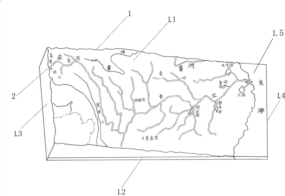
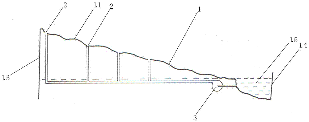
[0009] exist figure 1 , 2 Among them, the Wanli Yangtze River entering the sea model provided by the present invention is composed of a small water pump and a thermoplastic molded hard plastic film shell, and its feature is: the thermoplastic molded hard plastic film shell of the Wanli Yangtze River entering the sea model is made of hard plastic The topographic map of the Yangtze River Basin is printed in color on the film, and a convex-concave topographic model corresponding to the topographic map of the Yangtze River Basin is thermoplastically molded on the topographic map. The convex-concave topographic model has a plateau model, a mountain model, and a Sichuan Basin model of the Yangtze River Basin. The five major freshwater lake models, the mainstream and tributaries of the Yangtze River model, the bottom of the mainstream and tributaries of the Yangtze River is a smooth U-shaped trough, the plain model, and the above-ground suspended river model of the Yellow River and t...


PUM


Abstract

The invention belongs to the technical field of teaching aids and relates to a geographical teaching aid, in particular to a Yangtze river entering sea model. The model is composed of the two parts of a small water pump and a thermoplastic molding rigid plastic film case, the Yangtze river entering sea model is manufactured by the adoption of the technical scheme, because the model uses a miniature electric water pump to provide water for a U-shaped groove of a Yangtze river main stream and a tributary of a rigid plastic film case to run to make dynamic Yangtze entering sea demonstration, wherein the case is rectangular, printed with colors, formed by thermoplastic molding, high in the west and low in east and has convex-concave characteristics of the Yangtze river basin terrain, the teaching is carried out through lively activities, compared with images and texts on geography textbooks of planar-printed products, the model can display the geographical knowledge of the Yangtze river more visually and vividly, the student's interest for learning Yangtze river geography can be aroused, and therefore the Yangtze river geography is easier to understand, learn and remember.

Description

technical field [0001] The invention belongs to the technical field of teaching aids, and relates to a geography teaching aid, in particular to a model of the Wanli Yangtze River entering the sea. Background technique [0002] The Yangtze River is the largest river in China and the third largest river in the world. It originates from the roof of the world - the southwest side of Dandongela Peak in the Tanggula Mountains on the Qinghai-Tibet Plateau. Its main stream flows through Qinghai, Tibet, Sichuan, Yunnan, Chongqing, Hubei, and Hunan. 11 provinces, municipalities and autonomous regions, Jiangxi, Anhui, Jiangsu, and Shanghai, flow into the East China Sea east of Chongming Island, with a total length of more than 6,300 kilometers and a drainage area of ​​1.8 million square kilometers, accounting for about 20% of my country's land area. ethnic group with a population of about 400 million. Most people learn about the geography of the Yangtze River from geography textbooks, b...

Claims


Application Information

Patent Timeline
Patent Type & Authority Applications(China)
IPC IPC(8): G09B25/06
CPCG09B25/06
Inventor 马洪星
Owner 马洪星
Learn More