Method for constructing image control distribution network of image of unmanned aerial vehicle and matching optional ranges of aerial photographs

A matching method and distributed network technology, applied in the field of remote sensing image processing, can solve problems such as difficult matching, low efficiency, and non-standard image control network

Active Publication Date: 2017-07-11
POWER CHINA KUNMING ENG CORP LTD
View PDF7 Cites 9 Cited by
  • Summary
  • Abstract
  • Description
  • Claims
  • Application Information

AI Technical Summary

Problems solved by technology

This operation method has problems such as insufficient standardization of the image control network, difficulty in matching, and low efficiency. Therefore, it is urgent to ad

Method used


Image

  • Method for constructing image control distribution network of image of unmanned aerial vehicle and matching optional ranges of aerial photographs
  • Method for constructing image control distribution network of image of unmanned aerial vehicle and matching optional ranges of aerial photographs
  • Method for constructing image control distribution network of image of unmanned aerial vehicle and matching optional ranges of aerial photographs

Examples


Embodiment Construction

[0078] The present invention will be further described in detail below in conjunction with the examples.

[0079] Those skilled in the art will understand that the following examples are only for illustrating the present invention and should not be considered as limiting the scope of the present invention. If no specific technique or condition is indicated in the examples, it shall be carried out according to the technique or condition described in the literature in this field or according to the product specification. The reagents or instruments used were not indicated by the manufacturer, and they were all conventional products that could be purchased.

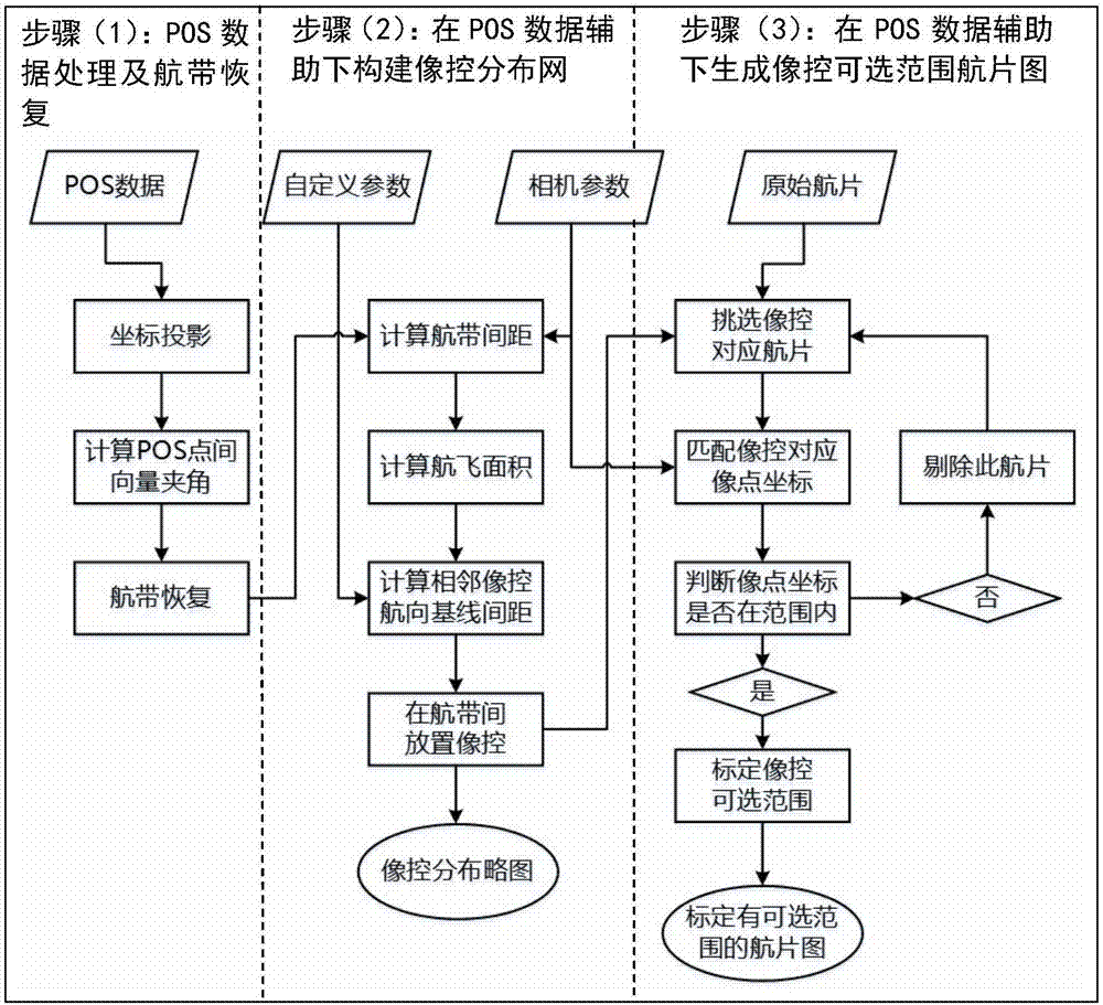
[0080] The technical scheme of the present invention can adopt computer software technology to realize automatic operation. Such as figure 1 As shown, the technical solution process of the embodiment includes the following steps:

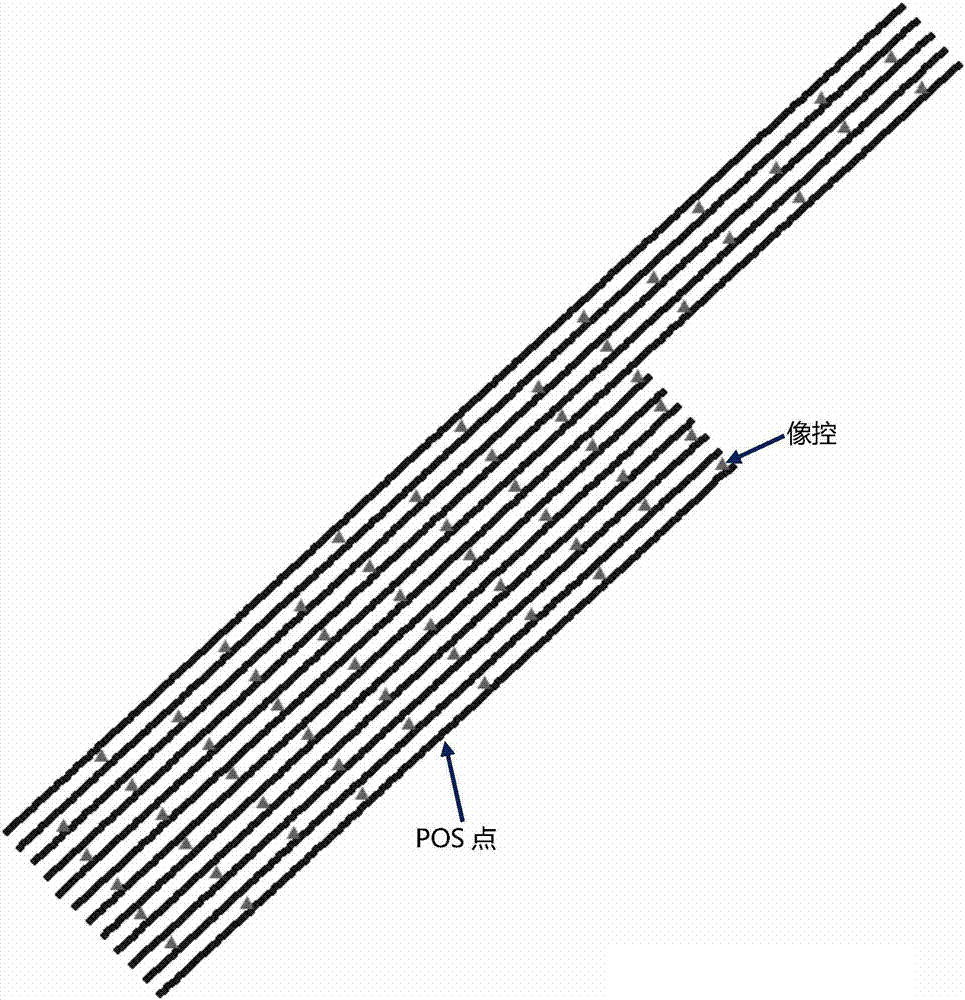
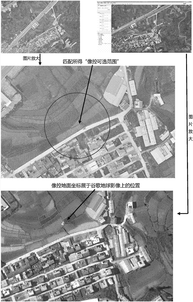
[0081] Step 1: POS data processing and airline recovery. POS data records the 6 outer orie...


PUM


Abstract

The invention relates to a method for constructing an image control distribution network of images of an unmanned aerial vehicle and matching optional ranges of aerial photographs, and belongs to the technical field of remote sensing image processing. The method is as follows: processing POS data, recovering an aerial strip model, and in the case of simple inputting of parameters, automatically calculating network type parameters; automatically constructing the image control distribution network under assistance of the POS data; and under the assistance of the POS data, automatically generating the aerial photographs calibrated with image control optional ranges by automatic matching of the image control distribution network. Through use of the POS data assisted method for constructing the image control distribution network of the images of the unmanned aerial vehicle and matching the optional ranges of the aerial photographs, through simple parameter assignment, the strong-universality uniform-distribution image control distribution network can be constructed, and the accurate-position moderate-range aerial photographs calibrated with the image control optional ranges can be fast matched. The method has the advantages of simple parameter setting, construction of image control distribution network type specification, high matching efficiency and the like.

Description

technical field [0001] The invention relates to the technical field of remote sensing image processing, in particular to a method for constructing an image control distribution network of unmanned aerial vehicle and matching the optional range of aerial photographs assisted by POS data. Background technique [0002] UAV aerial photography technology is a new digital surveying and mapping aerial photography technology after traditional aerial photography. Compared with traditional aerial photogrammetry, UAV aerial photography has the advantages of flexible take-off and landing, less affected by weather, and low cost. features. At present, the orthophoto map (DOM) and digital line map (DLG) produced by low-altitude digital remote sensing image technology can meet the accuracy requirements of 1:5000, 1:2000 and 1:1000 scales. [0003] The POS system, also known as the IMU / DGPS system, can measure the position and attitude of the sensor in real time during the imaging process, ...

Claims


Application Information

Patent Timeline
IPC IPC(8): G01C11/00
CPCG01C11/00
Inventor 吴弦骏闻平王媛吴小东李磊陈科吴杰桂林王辉杨文
Owner POWER CHINA KUNMING ENG CORP LTD
Why Eureka
Try Eureka