Urban high-resolution remote sensing image segmentation method based on improved jseg algorithm

A high-resolution, remote sensing image technology, applied in the field of image processing, can solve problems such as difficulty in effectively identifying complex and diverse urban scenes, loss of spectral and texture information, and ignoring complementary information of multi-band images.

Active Publication Date: 2018-05-15
郭建辉
View PDF4 Cites 0 Cited by
  • Summary
  • Abstract
  • Description
  • Claims
  • Application Information

AI Technical Summary

Problems solved by technology

However, these algorithms use too rough quantization before region segmentation, ignoring the complementary information between multi-band images, resulting in the loss of spectral and texture information that helps to locate the object boundary; at the same time, these methods extract The threshold value of the initial seed area is determined at a single scale, and it is difficult to effectively identify various types of ground objects with complex shapes and sizes in urban scenes

Method used


Image

  • Urban high-resolution remote sensing image segmentation method based on improved jseg algorithm
  • Urban high-resolution remote sensing image segmentation method based on improved jseg algorithm
  • Urban high-resolution remote sensing image segmentation method based on improved jseg algorithm

Examples


Embodiment Construction

[0024] Below in conjunction with specific embodiment, further illustrate the present invention, should be understood that these embodiments are only used to illustrate the present invention and are not intended to limit the scope of the present invention, after having read the present invention, those skilled in the art will understand various equivalent forms of the present invention All modifications fall within the scope defined by the appended claims of the present application.

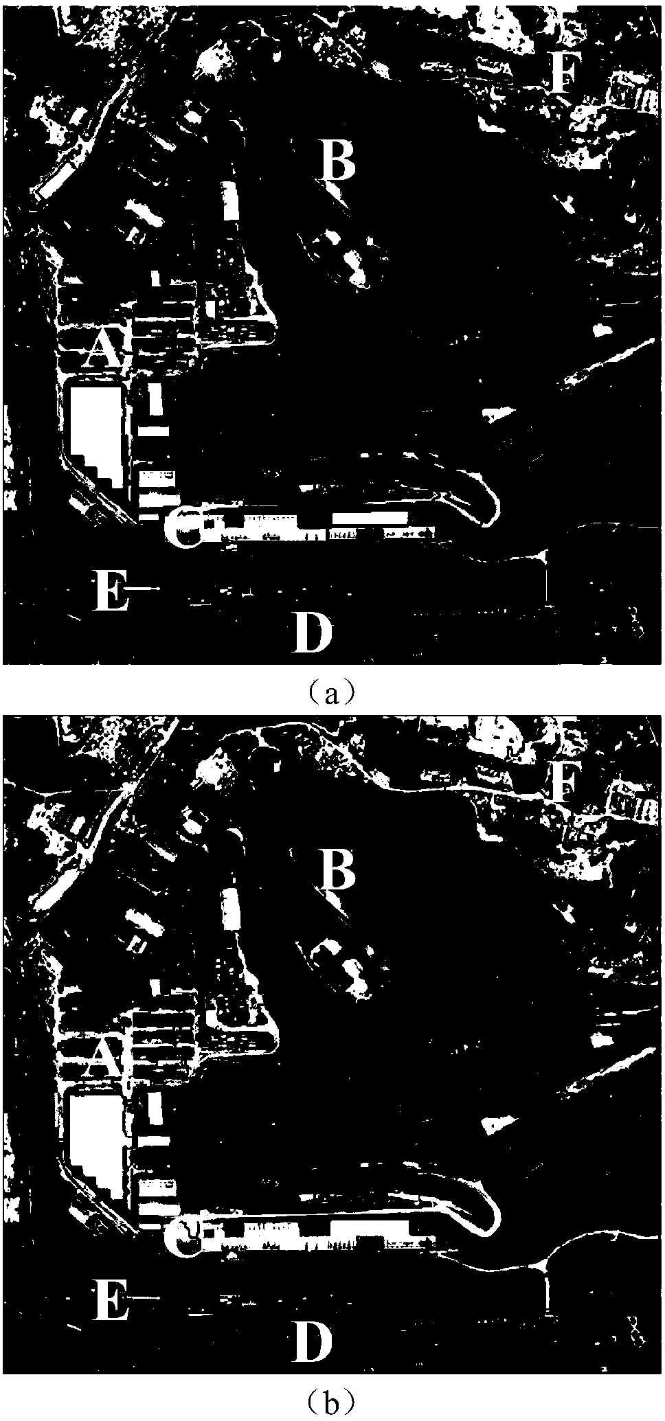
[0025] A method for urban high-resolution remote sensing image segmentation based on the improved JSEG algorithm, which mainly includes three steps: multi-band image fusion based on information entropy; multi-scale minimum value marker extraction based on J-value; multi-scale region segmentation and merging .

[0026] JSEG principle and limitation analysis

[0027] Before segmentation, the traditional JSEG algorithm first needs to perform color quantization on the multi-band image to obtain a sin...


PUM


Abstract

In order to solve problems of over segmentation, under segmentation, and difficult accurate positioning of an object boundary during high-resolution remote sensing image segmentation, the invention discloses an improved-JSEG-algorithm-based urban high-resolution remote sensing image segmentation method. According to the method, an information-entropy-based multi-band fusion strategy is used for obtaining a unified multi-scale J-image sequence, so that the detailed information loss caused by over-rough image quantization; multi-scale minimum marking is carried out by using a local homogeneity index J-value for to determine a seed area reasonably; and then regional segmentation and merging are carried out by using JSEG. In the experiment, high-resolution IKONOS and WorldView images are selected and comparison with JSEG and WJSEG is carried out. The result demonstrates that the real boundary of an object can be localized accurately, under segmentation and over segmentation problems can be solved effectively, and the segmentation precision and reliability can be improved when the method is used.

Description

technical field [0001] The invention relates to a method for segmenting urban high-resolution remote sensing images based on an improved JSEG algorithm, and belongs to the technical field of image processing. Background technique [0002] With the continuous improvement of spatial resolution of remote sensing images, object-oriented image analysis (OBIA, Object-Based Image Analysis) technology has been widely used in remote sensing image interpretation. Image segmentation is the basis of OBIA. It is responsible for extracting geographically meaningful objects in the scene. The quality of segmentation has a direct impact on the accuracy of subsequent image processing such as classification and change detection. [0003] Compared with medium- and low-resolution remote sensing images, high-resolution remote sensing images have richer spectrum, texture and spatial context information, which help to describe the outline features of ground objects more finely. But on the other ha...

Claims


Application Information

Patent Timeline
Patent Type & Authority Patents(China)
IPC IPC(8): G06T7/11G06T7/187
CPCG06T2207/10032G06T2207/20221
Inventor 郭建辉顾爱华王超
Owner 郭建辉
Why Eureka
Try Eureka