Data fusion method for laser radar and differential GPS and system

A GPS data and lidar technology, applied in radio wave measurement systems, satellite radio beacon positioning systems, surveying and navigation, etc., can solve the problems of time-consuming and large amount of calculation, increase security and save data processing time Effect

Pending Publication Date: 2017-08-25
JIANGSU PROTRULY VISION TECH GRP CO LTD +1
View PDF0 Cites 14 Cited by
  • Summary
  • Abstract
  • Description
  • Claims
  • Application Information

AI Technical Summary

Problems solved by technology

[0004] The technical problem to be solved by the present invention is to provide a data fusion method and system of laser radar and differential GPS

Method used


Image

  • Data fusion method for laser radar and differential GPS and system
  • Data fusion method for laser radar and differential GPS and system
  • Data fusion method for laser radar and differential GPS and system

Examples


Example Embodiment

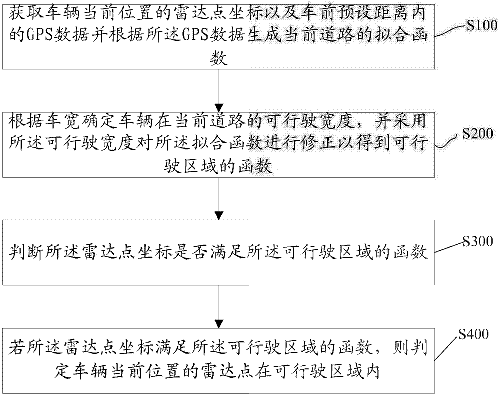
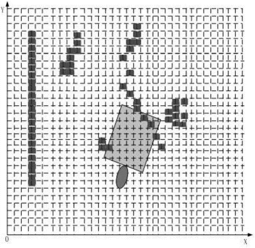
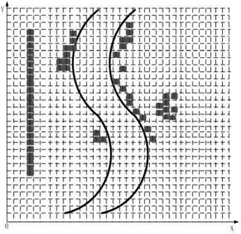
[0052] The present invention provides a data fusion method and system for lidar and differential GPS. In order to make the objectives, technical solutions and effects of the present invention clearer and clearer, the present invention will be further described in detail below with reference to the accompanying drawings and embodiments. It should be understood that the specific embodiments described here are only used to explain the present invention, but not to limit the present invention.

[0053] In the present invention, the use of suffixes such as "module", "part" or "unit" used to indicate elements is only for the purpose of facilitating the description of the present invention, and has no specific meaning in itself. Therefore, modules, “parts,” or “units” can be used in a mixed manner.

[0054] The terminal device can be implemented in various forms. For example, the terminal described in the present invention may include mobile phones, smart phones, notebook computers, digi...


PUM


Abstract

The invention discloses a data fusion method for laser radar and differential GPS and a system. The method comprises the following steps: acquiring a radar point coordinate of a present position of a vehicle and a GPS data in a preset distance in front of the vehicle and generating a fitting function of a present road according to the GPS data; confirming the driving width of the vehicle on the present road according to the vehicle width; correcting the fitting function according to the driving width, thereby acquiring a function of the driving area; judging if the radar point coordinate meets the function of the driving area; if the radar point coordinate meets the function of the driving area, judging if the radar point on the present position of the vehicle is in the driving area. According to the invention, the dispersing differential GPS road information is converted into a continuous function and then a position relation of the function and the laser radar point is utilized to judge the safety of the laser radar point. According to the method, a large amount of laser radar data processing time is saved and the safety of the pilotless automobile is increased.

Description

technical field [0001] The invention relates to the technical field of unmanned vehicles, in particular to a data fusion method and system of laser radar and differential GPS. Background technique [0002] The technology of unmanned vehicles is becoming more and more mature, and lidar and differential GPS navigation are playing an increasingly important role in the research progress of unmanned vehicles. Lidar perceives the environment, and differential GPS navigation establishes roads. Therefore, the data fusion of Lidar and differential GPS navigation has become one of the key technologies for unmanned vehicles. It determines the intelligence of unmanned vehicles in a certain sense. Safety assurance for driverless cars. On different road sections, unmanned vehicles need to decide different driving behaviors, and the main factor triggering different driving behaviors is the distribution and characteristics of obstacles in the drivable area. In the fusion of traditional li...

Claims


Application Information

Patent Timeline
IPC IPC(8): G01C21/34G01S17/93G01S19/45
CPCG01C21/3415G01S17/931G01S19/45
Inventor 庄敏鹿鹏龙刚李翊杨建锁张文娟刘以续
Owner JIANGSU PROTRULY VISION TECH GRP CO LTD
Why Eureka
Try Eureka