
Evaluation method of influence mechanism of sizes of DEM grid units to catchment area extraction

A grid unit and evaluation method technology, applied in the field of geographic information, can solve problems such as unclear impact evaluation methods

Inactive Publication Date: 2017-08-29
NANJING UNIV OF INFORMATION SCI & TECH
View PDF2 Cites 8 Cited by
  • Summary
  • Abstract
  • Description
  • Claims
  • Application Information

AI Technical Summary

Problems solved by technology

The existing algorithm points out the best spatial resolution of the DEM elevation for simulation, but when extracting the direction of water flow, calculating the cumulative amount of confluence, calculating the length of water flow, and dividing the watershed, the influence of the change of the grid cell size on the extraction of the catchment area Evaluation method is not clear

Method used


Image

  • Evaluation method of influence mechanism of sizes of DEM grid units to catchment area extraction
  • Evaluation method of influence mechanism of sizes of DEM grid units to catchment area extraction
  • Evaluation method of influence mechanism of sizes of DEM grid units to catchment area extraction

Examples


Embodiment Construction

[0014] The present invention will be further described below in conjunction with the accompanying drawings and specific embodiments.

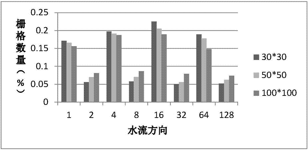
[0015] Assuming that the three sets of data are the DEM with a grid cell side length of 30 meters, the DEM with a grid cell side length of 50 meters, and the DEM with a grid cell length of 100 meters, use these three sets of data to achieve DEM with different grid cell sizes. Simultaneously a method for evaluating the impact of catchment extraction.

[0016] Step 1: Adjust the DEM grid cells of the study area to different sizes.

[0017] In this example, the side length of the grid cell in the research area is adjusted to 30m, 50m, and 100m, such as figure 1 .

[0018] Step 2: For the DEM data with different grid cell sizes, use ArcGIS hydrological analysis tools to extract and calculate water flow direction, water catchment volume, water flow length, watershed segmentation calculation, and water catchment area extraction.

[0019] In this e...


PUM


Abstract

The invention discloses an evaluation method of an influence mechanism of the sizes of DEM grid units to catchment area extraction. A catchment area is a basic unit of distributed hydrological surface water logging simulation, and different divisions of the catchment area have an important influence on storm water logging simulation results. When a hydrological analysis tool is used for researched area and water logging area extraction and the sizes of the DEM grid units are different, the four key links, including flow direction extraction, flow calculation, water flow length calculation and drainage basin segmentation, of catchment area extraction are conducted, each step changes, the steps influence one another, and finally influences in different degrees are generated on catchment area extraction. According to the method, the grid units with different sizes are used, and the flow direction, the flow accumulation amount, the water flow length and the changes degree of the drainage basin segmentation under different sizes of the grid units are analyzed, so that evaluation of the influence degrees of the flow direction, the flow accumulation amount, the water flow length and the drainage basin segmentation on catchement area extraction under the condition that the sizes of the grid units are different is achieved.

Description

technical field [0001] The invention relates to an evaluation method based on the influence of the size of a DEM grid unit on the extraction of a catchment area, and belongs to the technical field of geographic information. Background technique [0002] The digital elevation model (DEM) divides the regional space into several regular grid units according to the regular grid, and each grid unit corresponds to a bottom elevation value. Catchment area is the basic unit of distributed hydrological surface waterlogging simulation, and the different division of watershed area has an important impact on the simulation results of storm waterlogging. The ArcGIS hydrological analysis module can extract catchment areas through key links such as flow direction analysis, calculation of confluence accumulation, flow length calculation, and watershed segmentation. Among them, the cumulative amount of confluence is calculated according to the flow direction data of the terrain in the study...

Claims


Application Information

Patent Timeline
IPC IPC(8): G06F17/30G06F17/50
CPCG06F16/29G06F30/20
Inventor 薛丰昌唐步兴黄敏敏
Owner NANJING UNIV OF INFORMATION SCI & TECH
Learn More