Method for determining circular curve radius of road and driving sight distance based on GPS motion camera data

A technology of data determination and camera, which is applied in the direction of line-of-sight measurement, distance measurement, radio wave measurement system, etc., can solve problems such as low efficiency, achieve the effects of reducing manpower, improving measurement efficiency, and shortening on-site operation time

Active Publication Date: 2017-09-01
ZHENGZHOU UNIV
View PDF5 Cites 3 Cited by
  • Summary
  • Abstract
  • Description
  • Claims
  • Application Information

AI Technical Summary

Problems solved by technology

In the existing simple measurement method of highway technical indicators, the method of measuring the radius of the curve is to manually measure and compare multiple measurements on the spot with a tape measure; the sight distance is to use a wheel type rangefinder to perform multiple measurements along the centerline of the lane In contrast, both methods are less efficient

Method used


Image

  • Method for determining circular curve radius of road and driving sight distance based on GPS motion camera data
  • Method for determining circular curve radius of road and driving sight distance based on GPS motion camera data
  • Method for determining circular curve radius of road and driving sight distance based on GPS motion camera data

Examples


Embodiment 1

[0047] Embodiment one: the method for determining the radius of the road circle curve based on GPS motion camera data comprises the following steps:

[0048] 1. Data collection

[0049] Drive a vehicle equipped with a Garmin camera (model VIRB), drive along the centerline of the circular curve of the road to be tested (Y060 Township Road, Luoshan County) (at a speed of 30km / h), and record the driving trajectory with a GPS motion camera. GPS coordinate point information, the coordinate point position is updated and recorded every 1 second;

[0050] 2. Data processing

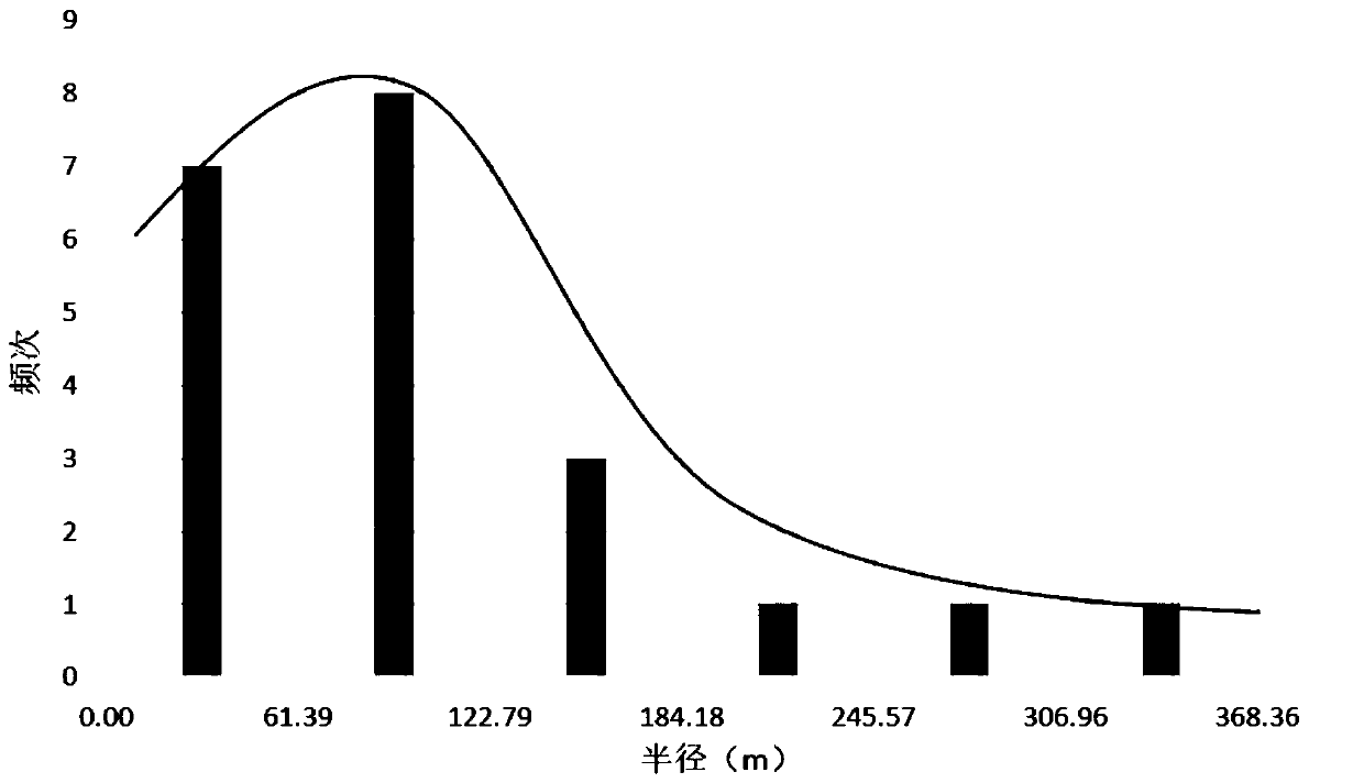
[0051] In this example, the coordinate record file in fit format is directly exported from the GPS sports camera, and the data format conversion software GPSbabel is used to convert the fit format file into kml format, and then import it to google earth to view relevant information; then use GPS TrackMaker software Convert the kml file into a txt file; finally import the txt file into Excel. Since the formed t...

Embodiment 2

[0069] Embodiment two: the method for determining road driving sight distance based on GPS motion camera data, comprises the steps:

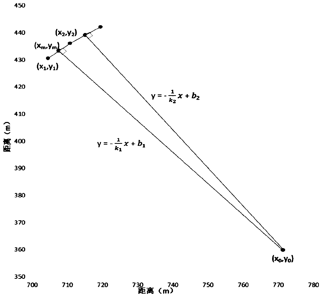
[0070] (1) According to the width of the road, the track line moved to the center line of the road is moved to the left and right sides respectively by a distance of 1 / 2 of the width of the roadbed (ie 3m), based on the GPS obtained in the calculation of the radius of the road circle curve in Example 1 The distance coordinates of the X and Y axes of the point, the coordinates of the corresponding point on the road edge line after the translation are calculated by formulas (g) and (h):

[0071]

[0072]

[0073] In the formula, (x', y') are the corresponding coordinates on the edge of the road; r is half of the roadbed width; when the road circular curve is a convex curve, a=1 when k is a positive number, and a when k is a negative number =-1, the situation is opposite when the road circular curve is a concave curve;

[0074] (2) Use matla...


PUM


Abstract

The invention relates to a method for determining a circular curve radius of a road and a driving sight distance based on GPS motion camera data. A GPS point coordinate point of a driving track is transformed into a corresponding two-dimensional orthogonal coordinate; according to the geometrical principle, calculation is carried out by using each three coordinate points as one group successively to obtain track line radiuses, wherein the mode of the multiple path radiuses is a circular curve radius of a corresponding lane; and then a road circular curve radius is obtained based on a corresponding position relation. Track lines moving to a road central line are moved left and right in a translation manner at distances being the half of the roadbed width; after the translation, track points fall at edges lines of the pavement; and a sight distance is calculated by using the conventional measuring method. The method has high advancement and exploitativeness. When the method is implemented, normal traffic of the road is not affected, so that the field working time can be shortened, the measuring efficiency can be improved, and the needed manpower and materials can be reduced.

Description

technical field [0001] The invention relates to the technical field of road safety protection, in particular to a method for determining the radius of a road circular curve and the driving sight distance based on GPS motion camera data. Background technique [0002] When studying road safety issues, it is necessary to measure the radius of the circular curve and the driving sight distance of the actual road. In the "Technical Guidelines for the Implementation of Highway Safety and Life Protection Engineering" and "Code for Safety Evaluation of Highway Projects" (JTG B05-2015) issued by the Ministry of Transport of the People's Republic of China, the minimum radius of the road circle curve and the visual There are clear requirements for distance. [0003] However, in engineering practice, there is a lack of fast and effective measurement methods for the radius of the road circle curve and the driving sight distance. In the existing simple measurement method of highway techn...

Claims


Application Information

Patent Timeline
Patent Type & Authority Applications(China)
IPC IPC(8): G01B21/20G01C3/24G01B11/255G01S19/19
CPCG01B11/255G01B21/20G01C3/24G01S19/19
Inventor 严亚丹王如航仝佩陈志举李辉
Owner ZHENGZHOU UNIV
Why Eureka
Try Eureka