Three-dimensional modeling data collection method based on multi-angle oblique photography device

A technology of oblique photography and data acquisition, applied in the field of drones, can solve problems such as difficulty in obtaining 3D images, incomplete data acquisition, and limited shooting range, and achieve the effects of perfect shooting information, wide shooting range, and improved modeling accuracy

Inactive Publication Date: 2017-09-15
南京赛飞地理信息技术有限公司
View PDF9 Cites 16 Cited by
  • Summary
  • Abstract
  • Description
  • Claims
  • Application Information

AI Technical Summary

Problems solved by technology

[0006] The bracket uses two cameras to shoot, and the angle between the cameras is controlled by the control device to change the shooting angle. However, the shooting range of its single-direction rotation is limited, the repetition rate is low, and the data collection is incomplete. It is difficult to obtain in the later three-dimensional modeling full 3D image

Method used


Image

  • Three-dimensional modeling data collection method based on multi-angle oblique photography device
  • Three-dimensional modeling data collection method based on multi-angle oblique photography device
  • Three-dimensional modeling data collection method based on multi-angle oblique photography device

Examples


Embodiment 1

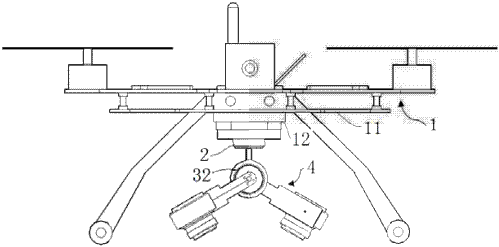
[0039] combine figure 1 , a kind of multi-angle oblique photography device of the present embodiment, comprises unmanned aerial vehicle body 11 and the stabilized cloud platform 12 that is arranged on the bottom of unmanned aerial vehicle 11, also comprises aerial photography cloud platform and aerial survey unit, and described aerial survey unit 4 centers are arranged symmetrically There are support plate 41 and camera 42, and described camera 42 is installed on the outer end of support plate 41, and the shooting angle between two cameras 42 is 35~70 °; The aerial photography platform is used to drive the aerial survey unit 4 to rotate in the vertical plane and the horizontal plane.

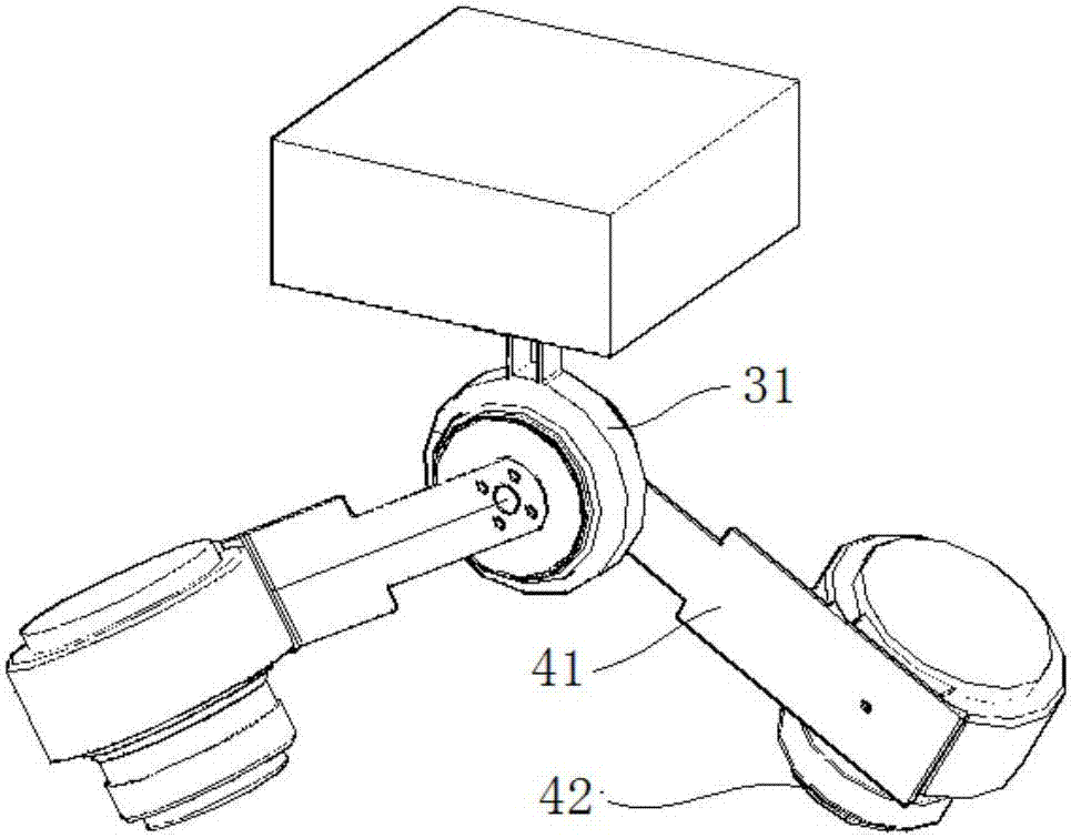
[0040] One end of the support plate 41 is connected with the steering gear, and the other end is installed with the camera 42 , that is, the outer end of the support plate 41 is connected with the camera 42 . The support plate 41 is mainly used for connecting the camera, and is not limited to a...

Embodiment 2

[0048] combine figure 1 with figure 2 , the multi-angle oblique photographing device of the present embodiment, its basic structure is identical with embodiment 1, and its difference is: in the present embodiment, the support of stabilizing the cloud platform 12 is fixed on the drone body 11 by bolts, the first rudder The outside of the machine 2 is equipped with a support seat, through which the first steering gear 2 is connected with the stabilization platform 12. The aerial photography platform includes a first steering gear 2 and a second steering gear 32 connected through an intermediate carrier 31 , and the rotation axis of the second steering gear 32 is connected with the aerial survey unit 4 .

[0049] The first steering gear 2 can be installed vertically, and its rotating shaft can rotate in the horizontal plane. The upper end of the intermediate carrier 31 is connected with the rotating shaft of the first steering gear 2, and the second steering gear 32 is installe...

Embodiment 3

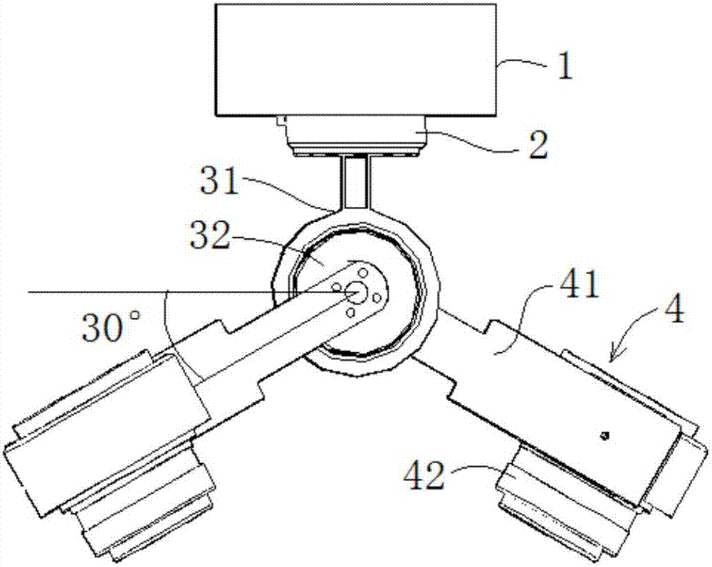
[0052] The multi-angle tilting photography device of this embodiment, its basic structure is identical with embodiment 2, and its difference is: first steering gear 2 is used for driving intermediate carrier 31 and second steering gear 32 to rotate 360 ​​° in the horizontal plane, control Each time it rotates 90°, it can collect shooting data of the target object from 4 directions.

[0053] The second steering gear 32 controls the aerial survey unit 4 to have two kinds of shooting attitudes. During the first attitude, the inclination angles of the two cameras 42 are the same, as image 3 As shown, the shooting angle between the two cameras 42 in the aerial survey unit 4 is limited to 60°, and the angle between the shooting direction of the two cameras 42 and the vertical direction is 30°.

[0054] After the rotating shaft of the second steering gear 32 rotates, it presents a second posture, such as Figure 4 As shown, one of the cameras 42 is located in a vertical shooting po...


PUM


Abstract

The invention discloses a three-dimensional modeling data collection method based on a multi-angle oblique photography device, and belongs to the field of unmanned planes. The method employs an unmanned plane body, a stability-augmenting PTZ camera disposed at the bottom of the unmanned plane body, an aerial photography PTZ camera, and an aerial surveying unit. The aerial surveying unit is provided with supporting plates and cameras in a manner of central symmetry. The cameras are installed at outer ends of the supporting plates, and the photographing angle between the two cameras is 35-70 degrees, The aerial photography PTZ camera is disposed on the stability-augmenting PTZ camera, and is used for driving the aerial surveying unit to rotate in a vertical plane and a horizontal plane. According to the invention, the method greatly reduces the weight of a photographing device through two cameras, improves the endurance, can achieve the higher photographing repetition rate, and guarantees the three-dimensional modeling accuracy.

Description

technical field [0001] The present invention relates to the technical field of unmanned aerial vehicles, and more specifically, relates to a method for collecting three-dimensional modeling data based on a multi-angle oblique photography device. Background technique [0002] In recent years, the field of international geographic information has combined traditional aerial photography technology and digital ground acquisition technology to develop a high-tech called airborne multi-angle oblique photography, referred to as oblique photography technology. Tilt photography technology collects ground images from multiple angles simultaneously by carrying multiple or multiple sensors on the same flight platform, thereby overcoming the limitation of traditional aerial photography technology that can only shoot from vertical angles, and can more truly reflect the ground The actual situation of the object makes up for the deficiency of the orthophoto, and realizes the 3D modeling tec...

Claims


Application Information

Patent Timeline
Patent Type & Authority Applications(China)
IPC IPC(8): G05D1/08G05D1/10
CPCG05D1/0808G05D1/101
Inventor 王楠楠卓磊吕万德卞雪菲秦亚兴
Owner 南京赛飞地理信息技术有限公司
Why Eureka
Try Eureka