Unmanned aerial vehicle multi-frame image self-adaptive positioning and correcting method based on aerial photography attitudes

A multi-frame image and aerial image technology, applied in the field of remote sensing image processing, can solve the problems of single-frame image not being fully utilized, unable to obtain unified and optimal results, etc., achieve high positioning accuracy, reduce the number of iterations, and improve positioning The effect of accuracy

Active Publication Date: 2017-09-22
BEIHANG UNIV
View PDF5 Cites 10 Cited by
  • Summary
  • Abstract
  • Description
  • Claims
  • Application Information

AI Technical Summary

Problems solved by technology

[0010] Due to the high overlap rate between a large number of aerial images during the aerial photography of the UAV, the correction and ground target positioning methods of single frame images do not make full use of this information
Moreover,

Method used


Image

  • Unmanned aerial vehicle multi-frame image self-adaptive positioning and correcting method based on aerial photography attitudes
  • Unmanned aerial vehicle multi-frame image self-adaptive positioning and correcting method based on aerial photography attitudes
  • Unmanned aerial vehicle multi-frame image self-adaptive positioning and correcting method based on aerial photography attitudes

Examples


Embodiment Construction

[0033] The present invention will be further described in detail below in conjunction with the accompanying drawings and specific embodiments.

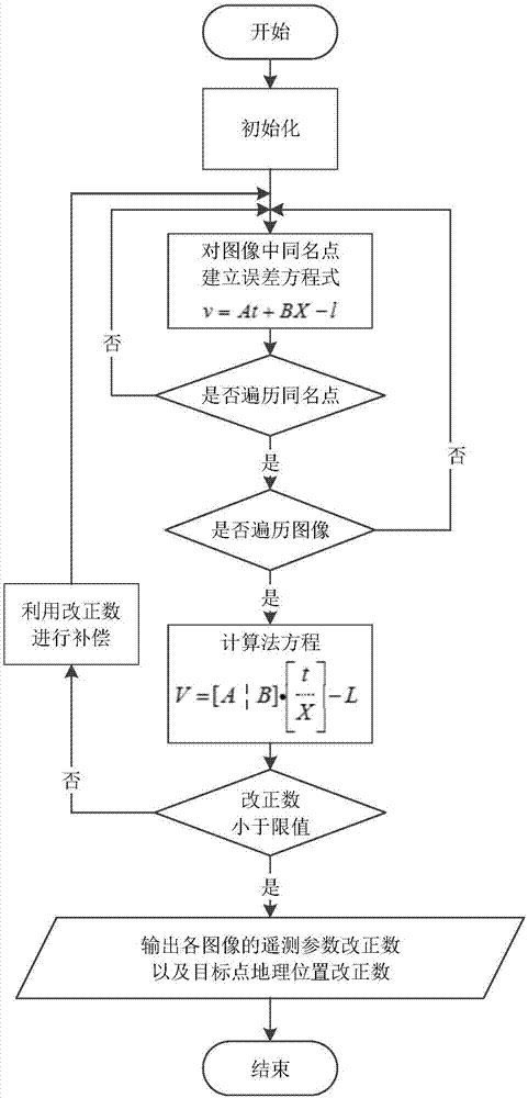
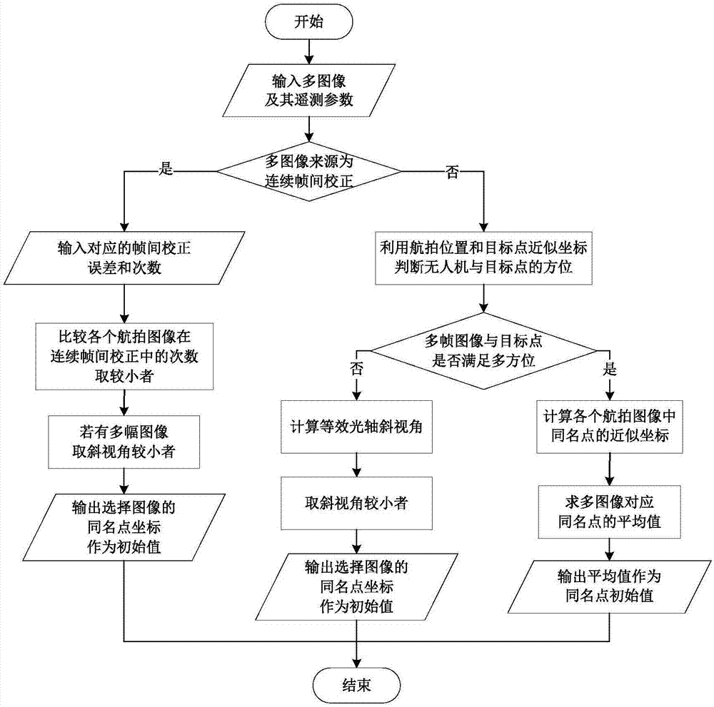
[0034] The present invention proposes an adaptive positioning correction method for multi-frame images of UAVs based on aerial photography attitude. The method adopts different initialization strategies for different sources of multi-frame images, so that the method can not only compensate the The systematic error of multi-frame images can further improve the parameter accuracy of continuous multi-frame correction and positioning. This method can accurately and real-time perform error correction on multiple acquired images with a common area during the online aerial photography process of the UAV, and improve the accuracy of positioning results.

[0035] The self-adaptive positioning and correction method of multi-frame images of UAV based on aerial photography attitude provided by the present invention, such as figure 1 shown, inclu...


PUM


Abstract

The invention provides an unmanned aerial vehicle multi-frame image self-adaptive positioning and correcting method based on aerial photography attitudes, and belongs to the technical field of remote sensing image processing. The method comprises the main steps that firstly, self-adaptive initialization is carried out, wherein different initialization strategies are used for different sources of multi-frame images, and different initial values are selected for different flight attitudes; secondly, the number of correspondingly required homonymy points is determined according to the number of input image frames; thirdly, an error equation is established by utilizing constraint conditions between the images by utilizing the bundle adjustment method, all the homonymy points of each image are traversed, and a normal equation is established; fourthly, a correction number is added to an approximate value to serve as a new approximate value for iteration till the correction number is smaller than a limit value, and the correction number is output. Error correction is conducted on the acquired images with the common region accurately in real time in the online aerial photography process of an unmanned aerial vehicle, and the accuracy of a positioning result is improved.

Description

technical field [0001] The invention belongs to the technical field of remote sensing image processing, and in particular relates to an adaptive positioning and correction method for multi-frame images of an unmanned aerial vehicle based on aerial photography attitude. Background technique [0002] As UAVs are widely used in detection, surveillance, tracking and other fields, the requirements for the accuracy of UAV aerial image positioning technology for ground targets have become more stringent. However, it is difficult to improve the accuracy of UAV image correction and ground target positioning due to many reasons. The error directly affects the accuracy of the subsequent calculation of the corrected positioning; and the wide detection range of the UAV makes it impossible for the positioning algorithm based on the ground control point information with high positioning accuracy to be widely used. [0003] In terms of specific operation methods, domestic and foreign resea...

Claims


Application Information

Patent Timeline
IPC IPC(8): G01C11/02G01C11/08G01C11/12
CPCG01C11/02G01C11/08G01C11/12
Inventor 丁文锐李健昆李红光刘家良
Owner BEIHANG UNIV
Why Eureka
Try Eureka