PS-InSAR technology-based historical settlement risk assessment method for surrounding environments along subways

A technology for surrounding environment and subsidence risk, applied in radio wave measurement systems, radio wave reflection/re-radiation, image data processing, etc. problem, to achieve the effect of improving precision and accuracy

Inactive Publication Date: 2017-09-29
北京东方至远科技股份有限公司
View PDF2 Cites 21 Cited by
  • Summary
  • Abstract
  • Description
  • Claims
  • Application Information

AI Technical Summary

Problems solved by technology

One of the important reasons for the frequent occurrence of environmental accidents around the construction of rail transit projects is that the historical settlement and deformation of roads and buildings (structures) along the line are not clear, and the risk awareness is insufficient: 1) the existing roads, buildings, bridges, etc. Lack of understanding of displacement and subsequent allowable displacement margin; 2) Insufficient investigation of unfavorable geological conditions behind the excessive deformation of surface subsidence
Therefore, it takes a lot of time, manpower, material and financial resources to conduct deformation monitoring with conventional precision levels, and it is difficult to accurately determine the range of deformation influence along the line
At the same time, due to the problems of sparse distribution of measuring points, long operation period and high labor intensity in traditional precision leveling observation and GPS observation, it is difficult to timely and objectively reflect the ever-expanding regional land subsidence change trend

Method used


Image

  • PS-InSAR technology-based historical settlement risk assessment method for surrounding environments along subways
  • PS-InSAR technology-based historical settlement risk assessment method for surrounding environments along subways
  • PS-InSAR technology-based historical settlement risk assessment method for surrounding environments along subways

Examples


Embodiment Construction

[0037] The specific implementation manners of the present invention will be further described in detail below in conjunction with the accompanying drawings and embodiments. The following examples are used to illustrate the present invention, but are not intended to limit the scope of the present invention.

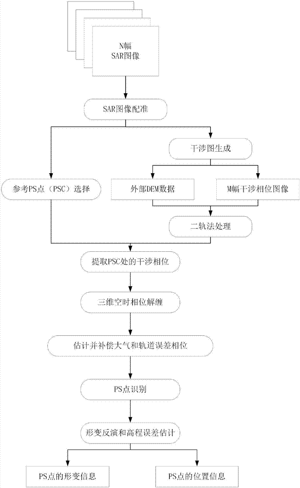
[0038] Such as figure 1 As shown, the best embodiment of the present invention's method for evaluating the historical settlement risk of the surrounding environment along the subway line based on PS-InSAR technology, including:

[0039] Taking N SAR images as input, all SAR images are registered to the same grid by image registration method. Then, the SAR image pair with smaller temporal and spatial baselines is selected to generate an interferogram, and the interferometric phase introduced by terrain fluctuations is removed by the two-track method. At the same time, candidate PS points (PSCs) are selected in the image, and the information of the PSCs is used to compensate...


PUM


Abstract

The invention relates to a PS-InSAR technology-based historical settlement risk assessment method for surrounding environments along the subways. The method comprises the steps of employing N SAR images as input, registering all SAR images into a same mesh through an image registration method; selecting SAR images which are relatively small in time baseline and space baseline to generate an interferogram and removing an interferometric phase caused by topographic relief through a two-pass method; selecting candidate PS points (PSC) from the images, and compensating an error phase caused by an atmospheric change and an error phase caused by inaccurate orbit data by using information of the PSCs; and carrying out point-to-point analysis on all pixel points in the images by using the compensated phase information, identifying PS points again, and estimating deformation information and elevation error information thereof.

Description

technical field [0001] The invention relates to a historical settlement risk assessment method for the surrounding environment along a subway line based on PS-InSAR technology. Background technique [0002] Urban rail transit projects induce surrounding environmental accidents such as housing cracks, pipeline breaks, and road collapses. In addition to being related to the deformation and displacement of the surrounding environment caused by rail transit construction, it is also closely related to the previous historical deformation and displacement of the surrounding environment itself. One of the important reasons for the frequent occurrence of environmental accidents around the construction of rail transit projects is that the historical settlement and deformation of roads and buildings (structures) along the line are not clear, and the risk awareness is insufficient: 1) the existing roads, buildings, bridges, etc. There is a lack of understanding of displacement and subse...

Claims


Application Information

Patent Timeline
Patent Type & Authority Applications(China)
IPC IPC(8): G01C5/00G01S13/89G06T7/30
CPCG01C5/00G01S13/89G06T2207/10044G06T2207/30181G06T7/30
Inventor 丁连军尹宁李吉平白玉江范胜文葛春青班勇朱茂
Owner 北京东方至远科技股份有限公司
Why Eureka
Try Eureka