
Urban impervious surface information extraction method fusing interest point big data

A technology of information extraction and points of interest, which is applied in the field of urban impervious surface information extraction, can solve the problem that impervious surface information cannot meet the high spatial resolution information data requirements, cannot determine the specific location of impervious surfaces, and restricts impervious surface information Extraction effects and other issues, to achieve the effects of strong practicability, improved accuracy and resolution, and reduced uncertainty

Active Publication Date: 2017-09-29
HOHAI UNIV +1
View PDF10 Cites 4 Cited by
  • Summary
  • Abstract
  • Description
  • Claims
  • Application Information

AI Technical Summary

Problems solved by technology

However, there are still several problems to be solved in these methods: (1) The extraction accuracy of impervious surfaces is still limited, mainly because impervious surfaces are often located in complex urban areas, and various information are interlaced; (2) Mixed images The meta-problem still exists in all kinds of images, which limits the effect of impervious surface information extraction; (3) The impervious surface information extracted from low- and medium-resolution images is often difficult to meet the high spatial resolution information required by the city. (4) Most of the methods can only get the amount of impervious surface information in each pixel (the proportion of impervious surface), but cannot determine the specific position of the impervious surface in each pixel
[0004] Although super-resolution mapping can be used as a potential means to solve the problem of impervious surface information extraction, it is an underdetermined technology that requires more effective constrained auxiliary information to obtain higher accuracy.

Method used


Image

  • Urban impervious surface information extraction method fusing interest point big data
  • Urban impervious surface information extraction method fusing interest point big data
  • Urban impervious surface information extraction method fusing interest point big data

Examples


Embodiment Construction

[0020] The present invention will be further described below in conjunction with the accompanying drawings.

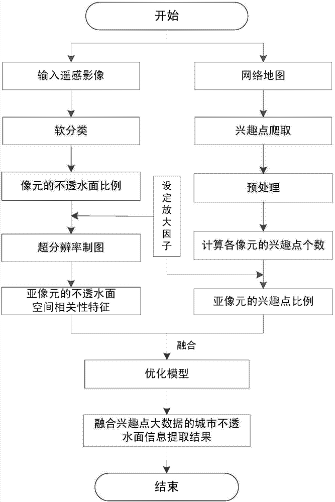
[0021] Such as figure 1 As shown, a method for extracting urban impermeable surface information by integrating big data of points of interest, the specific implementation steps are as follows:

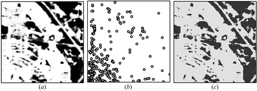
[0022] Step 1. Preprocess the remote sensing images, and perform soft classification based on pixels to obtain the proportion value of the impervious surface in each pixel, such as figure 2 as shown in (a);

[0023] Step 2. Set the zoom scale factor S, divide each pixel in the impervious surface scale map obtained in step 1 into multiple fine sub-pixels, and perform super-resolution mapping. Relying on the principle of spatial correlation, the center image The proportion value of the impervious surface in the cell and its neighboring pixels, and obtain the spatial correlation characteristic value of the impervious surface of each sub-pixel in the central pixel;

[0024] The...


PUM


Abstract

The invention discloses an urban impervious surface information extraction method fusing interest point big data. The method comprises the steps of firstly, introducing a remote sensing super-resolution mapping technology, and according to the first law of geography, acquiring impervious surface spatial correlation characteristic values of internal fine sub pixels from an impervious surface proportion value of each pixel; secondly, crawling interest point big data from a network map, and acquiring the percentage of the number of interest points of each sub pixel in the total number of interest points of the pixel; thirdly, fusing the information of each sub pixel in the above two steps; and finally, constructing a spatial optimization model using a remote sensing image and the interest point big data, and acquiring a fine accurate result of the internal impervious surface information of the pixel under the sub pixel scale, thus realizing accurate extraction of urban impervious surface information. The method has the characteristics of strong practicability, high simulation precision and the like, and is applicable to geo-scientific researches on urban expansion, urban heat land effect, urban water resource protection and the like.

Description

technical field [0001] The invention relates to a method for extracting urban impermeable surface information by integrating big data of points of interest, and belongs to the technical field of geospatial information. Background technique [0002] Impervious surfaces mainly refer to artificial surfaces that water cannot penetrate, and can be used as a key factor in many fields, such as urban expansion, urban heat island effect, and urban water resource protection. Accurately extracting impervious surface information from remote sensing images has been a research hotspot of many scholars at home and abroad. At present, there are mainly four types of methods: (1) pixel-based hard classification; (2) pixel-based soft classification; (3) object-based classification; (4) related methods based on artificial neural networks. These methods have been tried in different applications in various images, and have achieved good results. However, there are still several problems to be s...

Claims


Application Information

Patent Timeline
IPC IPC(8): G06K9/00
CPCG06V20/13Y02A30/60
Inventor 陈跃红安如周亚男黄理军陈正富
Owner HOHAI UNIV
Learn More