Inertial navigation positioning system based on UWB ranging

A positioning system and base station positioning technology, applied in the field of inertial navigation positioning, can solve the problems of untrustworthy position information, complicated operation, and inability to inform combatants of the direction, and achieve the effect of reducing positioning costs

Inactive Publication Date: 2017-10-27
上海瀚界科技发展有限公司
View PDF3 Cites 44 Cited by
  • Summary
  • Abstract
  • Description
  • Claims
  • Application Information

AI Technical Summary

Problems solved by technology

[0004] In the current related technology, in order to solve the problem of serious distrust of position information after a long time caused by inertial navigation sensor drift and cumulative errors in a closed space, the applicant applied for a patent in 2016 called "A UWB-based Inertial Navigation The invention patent of "origin positioning method and system" can make the inertial navigation initialization flexible and convenient. When there are multiple inertial navigation equipment, it is not necessary to maintain the consistency of multiple inertial navigation equipment initialization, and it can be easily applied to indoors and outdoors. Various environments, and can observe the position of combatants in the back end in real time
However, the inventors of the present application found that there are at least the following defects in the prior art during the practice of the application, that is, because the environment of the fighters carrying the inertial navigation in the system is determined by two UWB anchor nodes that can be placed at will It makes it impossible to map and determine the position of the combatants on the satellite map. Generally, the command center needs to be set to match the actual position. The operation is more complicated, and it is impossible to inform the combatants of the exact direction.

Method used


Image

  • Inertial navigation positioning system based on UWB ranging
  • Inertial navigation positioning system based on UWB ranging
  • Inertial navigation positioning system based on UWB ranging

Examples


Embodiment Construction

[0032] The specific implementation manners of the embodiments of the present invention will be described in detail below in conjunction with the accompanying drawings. It should be understood that the specific implementation manners described here are only used to illustrate and explain the embodiments of the present invention, and are not intended to limit the embodiments of the present invention.

[0033]It should be noted that, in the description of the present invention, the terms "first" and "second" are only used to describe different components conveniently, and should not be understood as indicating or implying a sequence relationship, relative importance, or implicit indication. The number of technical characteristics. Thus, the features defined as "first" and "second" may explicitly or implicitly include at least one of these features.

[0034] In the description of the present invention, it should be understood that the orientations or positional relationships indi...


PUM


Abstract

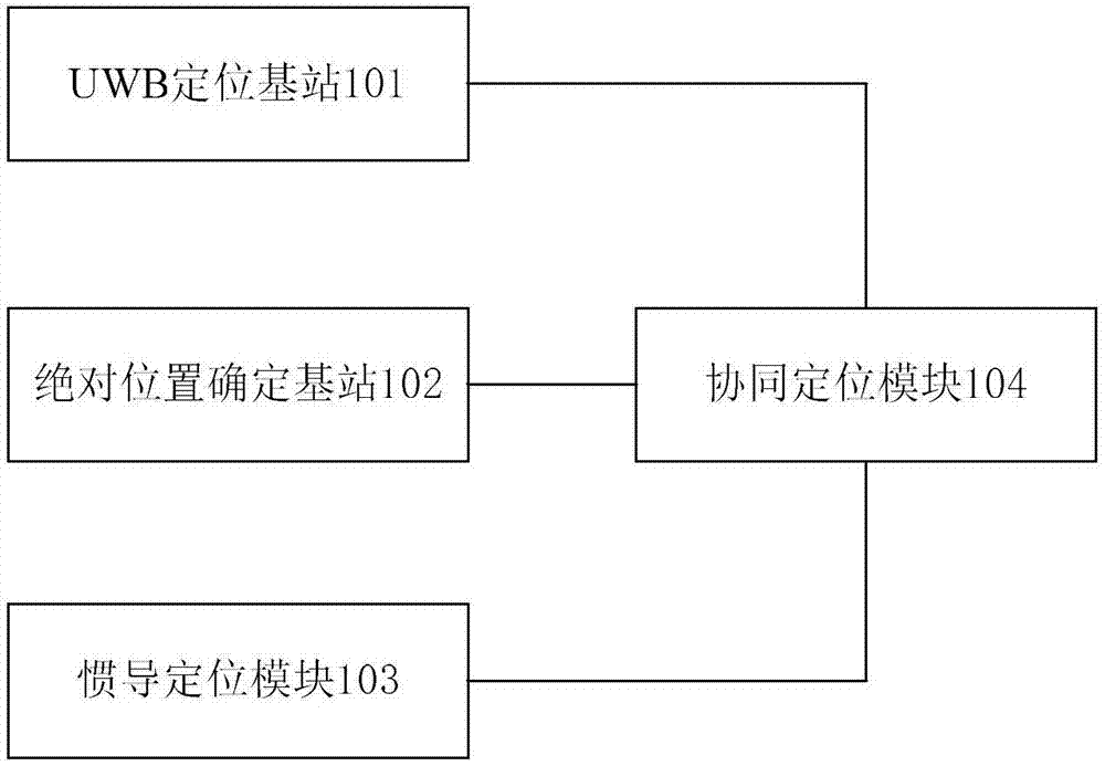
An embodiment of the invention provides an inertial navigation positioning system based on UWB ranging. The inertial navigation positioning system comprises a UWB positioning base station, an absolute position determining base station, an inertial navigation positioning module and a cooperative positioning module, wherein the UWB positioning base station is arranged in a target positioning area and used for determining UWB relative positioning data of a to-be-positioned object by use of the relative position of the positioning base station determined by the communication interaction and arrangement way of a UWB label carried by the to-be-positioned object; the absolute position determining base station is arranged at the UWB positioning base station and used for determining the absolute position of the UWB positioning base station; the inertial navigation positioning module is carried by the to-be-positioned object and used for determining inertial navigation positioning data of the to-be-positioned object; the cooperative positioning module is carried by the to-be-positioned object and used for determining absolute positioning data of the to-be-positioned object according to the UWB relative positioning data, the inertial navigation positioning data and the relative position and corresponding absolute position of the UWB positioning base station. Through cooperative application of UWB positioning, absolute position base station and inertial navigation positioning technology, the absolute positioning data of the to-be-positioned object can be accurately obtained in a geographic area with relatively poor absolute positioning signal.

Description

technical field [0001] The invention relates to the technical field of inertial navigation and positioning, in particular to an inertial navigation and positioning system based on UWB ranging. Background technique [0002] At present, in the application of military exercises such as special police and armed police, the position and status information of individual soldiers in the long distance and indoors is a major focus of the backfield commanders. In order to realize real-time monitoring and command of combat personnel, the positioning system and its technology Higher level requirements are also raised. [0003] The inertial navigation system is a navigation parameter calculation system with gyroscopes and accelerometers as sensitive devices. The system establishes a navigation coordinate system based on the output of the gyroscope, and calculates the speed and position of the carrier in the navigation coordinate system based on the output of the accelerometer. Dead reck...

Claims


Application Information

Patent Timeline
Patent Type & Authority Applications(China)
IPC IPC(8): G01C21/16
CPCG01C21/165
Inventor 康琴韩乃军
Owner 上海瀚界科技发展有限公司
Why Eureka
Try Eureka