A method for precise location and assessment of soil pollution based on geophysical detection technology
What is AI technical title?
AI technical title is built by Patsnap AI team. It summarizes the technical point description of the patent document.
A geophysical and soil pollution technology, applied in geophysical measurement, instruments, etc., can solve problems such as low estimation accuracy, influence on risk management and control decisions, repair cost estimation, and defective scope of application, and achieve the effect of improving estimation accuracy
Active Publication Date: 2019-02-01
SHANGHAI ACADEMY OF ENVIRONMENTAL SCIENCES
View PDF6 Cites 2 Cited by
Summary
Abstract
Description
Claims
Application Information
AI Technical Summary
This helps you quickly interpret patents by identifying the three key elements:
Problems solved by technology
Method used
Benefits of technology
Problems solved by technology
The overall points of the traditional survey method are relatively sparse, and the location of the points is chosen arbitrarily, and it is easy to miss the polluted area. Most of them can only estimate the overall soil pollution status of the site or region based on the "point exceeding standard rate".
Although the traditional soil pollution investigation point distribution method with the goal of "overall estimation" has an acceptable estimation accuracy for the average concentration of pollutants, the estimation accuracy for the spatial distribution (range) of pollution is low, which usually affects risk management and control decisions. and repair cost estimates
[0005] (2) Traditional survey methods are difficult to achieve "full coverage" surveys in the target area, resulting in flawed scope of application
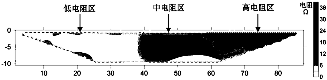
[0017] However, no one has applied the combination technology of frequency domain electromagnetic induction instrument-high-density resistivity instrument-ground penetrating radar in a step-by-step and targeted manner to the investigation of site pollution environment. point", and finally return to the "surface" soil pollution investigation process
Method used
Image
Click on the blue label to locate the original text in one second.
Reading with bidirectional positioning of images and text.
Examples
Embodiment 1
[0063] Soil Environmental Pollution Investigation of an Organic Polluted Site
[0064] The chemical plant covers an area of about 25 mu. It was built around 1991 and was demolished in 2016. Mainly engaged in coatings, chemical solvents, benzyl chloride, chemical additives, trimethoxyaldehyde benzaldehyde, reagents, industrial alcohol, paoli water, etc. Before the site survey was carried out, all the buildings and floors in the site were demolished, the construction waste had been completely removed, and the land had been leveled. There is little background information on the site, and the floor plan of the factory area has not been mastered.
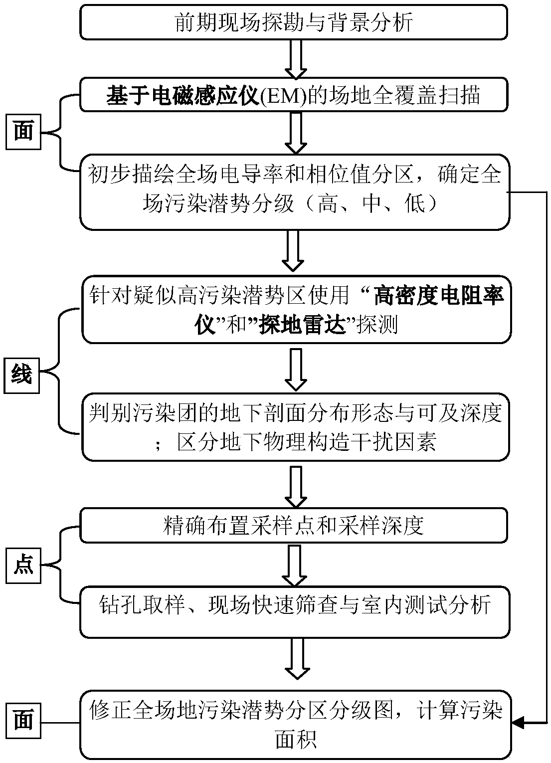
[0065] The present invention is a soil pollution precise positioning and accurate assessment method based on geophysical detection technology, which completes the following site investigation work step by step:
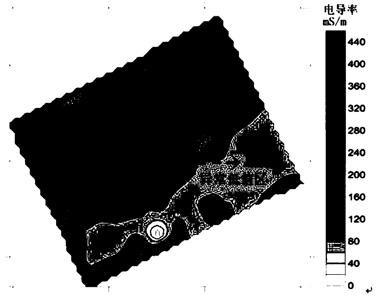
[0066] (1) Use electromagnetic induction instruments on the "surface" to carry out rapid screening of full coverage of the...
Embodiment 2
[0080] Soil Environmental Pollution Investigation of a Heavy Metal Contaminated Site
[0081] The enterprise site covers an area of about 4 mu, and began to produce dyes and antifungal agents in the early 1970s. The main production raw materials are iron powder, zinc chloride, hydrochloric acid, aniline and so on. Production stopped around 2005, and the site was basically idle. At the end of November 2016, the demolition of the above-ground buildings was completed. When the site was inspected, the construction waste was basically cleaned up, the concrete floor was basically intact, and there were some old production equipment, pipes, and storage tanks on the ground.
[0082] The present invention is a soil pollution precise positioning and accurate assessment method based on geophysical detection technology, which completes the following site investigation work step by step:
[0083] (1) Use electromagnetic induction instruments on the "surface" to carry out rapid screenin...
PUM
Abstract
The invention discloses a method for accurately positioning soil contamination based on geophysical exploration and an accurate estimation method. The method for accurately positioning soil contamination includes the following steps: on-site surveying, rapid exploration which covers entire site from the width perspective, further contamination body and availability positioning from the depth perspective, drilling sampling and analysis verification from specific point perspective, and accurate contamination level evaluation from the width perspective. In specific target sites or regions, the method herein adopts geophysical exploration technology which combines electromagnetic instruments, high density resistivity meters and ground penetrating radars in a step-by-step and targeted manner, can accurately position areas or points that are suspected to have soil contamination, arranges sapling points in a scientific manner, combines rapid site contamination pollution screening as well as drilling sampling, test and analysis, and establishes an entire set of soil pollution investigation procedures from the width perspective, the depth perspective and the specified point perspective. Themethod herein can rapidly and accurately position soil contamination, scientifically arrange sampling points, conducts soil contamination investigation that cover an entire region, and increases theprecision in estimating the contamination area.
Description
technical field [0001] The invention belongs to the technical field of environmental monitoring and relates to a method for precise positioning and accurate evaluation of soil pollution based on geophysical detection technology. Background technique [0002] In the past 30 years, with the rapid development of social economy and high-intensity human activities, the problem of soil environmental safety in my country has become increasingly prominent, which has attracted widespread attention from the society. "Carrying out soil pollution investigations and grasping the status of soil environmental quality" has become the primary task of the country's "Soil Pollution Prevention and Control Action Plan". Compared with water body and air pollution, soil pollution has the characteristics of inhomogeneity; due to differences in soil types and properties, as well as differences in pollutants and regional hydroclimatic characteristics, the diffusion, migration, degradation, and retent...
Claims
Application Information
Patent Timeline
Application Date:The date an application was filed.
Publication Date:The date a patent or application was officially published.
First Publication Date:The earliest publication date of a patent with the same application number.
Issue Date:Publication date of the patent grant document.
PCT Entry Date:The Entry date of PCT National Phase.
Estimated Expiry Date:The statutory expiry date of a patent right according to the Patent Law, and it is the longest term of protection that the patent right can achieve without the termination of the patent right due to other reasons(Term extension factor has been taken into account ).
Invalid Date:Actual expiry date is based on effective date or publication date of legal transaction data of invalid patent.

