Method for automatically extracting elevation point of road topographic map based on vehicle-borne LiDAR data

A vehicle-mounted laser radar and automatic extraction technology, which is applied in the field of resource and environment remote sensing or surveying and mapping science, can solve problems such as low efficiency, difficulty in meeting precision requirements, and high precision

Active Publication Date: 2018-02-02
南京市测绘勘察研究院股份有限公司
View PDF3 Cites 10 Cited by
  • Summary
  • Abstract
  • Description
  • Claims
  • Application Information

AI Technical Summary

Problems solved by technology

The former manual method has low efficiency, but high precision; the latter has high efficiency, but it is not easy to meet the precision requirements stipulated in the large-scale topographic map specification

Method used


Image

  • Method for automatically extracting elevation point of road topographic map based on vehicle-borne LiDAR data
  • Method for automatically extracting elevation point of road topographic map based on vehicle-borne LiDAR data
  • Method for automatically extracting elevation point of road topographic map based on vehicle-borne LiDAR data

Examples


Embodiment Construction

[0028] Below in conjunction with accompanying drawing and specific embodiment, further illustrate the present invention, should be understood that these embodiments are only for illustrating the present invention and are not intended to limit the scope of the present invention, after having read the present invention, those skilled in the art will understand various aspects of the present invention Modifications in equivalent forms all fall within the scope defined by the appended claims of this application.

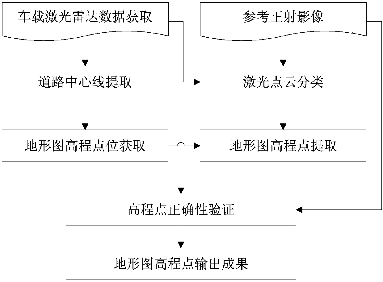
[0029] A method for automatically extracting elevation points of a road topographic map based on vehicle-mounted laser radar data, comprising the steps of:

[0030] The first step is data acquisition: including vehicle-mounted lidar point cloud data acquisition and orthophoto collection; using laser scanning vehicles to collect laser scanning data on the road; the collection time should be selected at night when there are fewer vehicles on the road, so that High-quality ...


PUM


Abstract

The present invention discloses a method for automatically extracting an elevation point of a road topographic map based on vehicle-borne LiDAR data. The method comprises a step of obtaining vehicle-borne LiDAR point cloud data and classifying surface points and non-surface points with commercial software and a step of extracting a road center line according to a trajectory line of vehicle-borne scanning, determining a position of an elevation point to be extracted, and thus obtaining elevation point three-dimensional coordinates needed by the road topographic map. Compared with the prior art,the method provided by the invention has the advantages that a method of topographic map elevation point automatic acquisition and elevation value automatic acquisition suitable for vehicle-borne laser point cloud is invented and used, and the elevation point required for a road area topographic map can be extracted according to vehicle-borne laser point cloud data.

Description

technical field [0001] The invention relates to a method for automatically extracting elevation points of road topographic maps based on vehicle-mounted laser radar data. The technical field of the invention is the field of remote sensing of resources and environment or surveying and mapping science and technology, and is especially suitable for automatic acquisition of large-scale topographic map data. Background technique [0002] In the surveying and mapping of large-scale topographic maps, the data of elevation points obtained by manual use of instruments is quite mature in technology. One is to use a total station or RTK to make dots, and the other is to use a digital photogrammetry workstation to obtain stereograms. The former manual method has low efficiency, but high precision; the latter has high efficiency, but it is not easy to meet the precision requirements stipulated in the large-scale topographic map specification. Therefore, it is imperative to develop a met...

Claims


Application Information

Patent Timeline
Patent Type & Authority Applications(China)
IPC IPC(8): G06T7/521G06T17/05
CPCG06T17/05G06T2207/10028G06T7/521
Inventor 韩文泉胡春霞沈雨陈昕胡伍生王孟和
Owner 南京市测绘勘察研究院股份有限公司
Why Eureka
Try Eureka