Geographical map deformation visualization method based on boundary reservation

A map and geography technology, applied in the field of geographic map deformation and visualization based on boundary preservation, can solve problems such as difficult to completely cover information, not allowing users to superimpose information, and irregular maps, so as to preserve the original geographic edge, build a simplified map, and The effect of less work

Inactive Publication Date: 2018-03-06
ZHEJIANG UNIV OF TECH
View PDF4 Cites 9 Cited by
  • Summary
  • Abstract
  • Description
  • Claims
  • Application Information

AI Technical Summary

Problems solved by technology

However, existing map forms are difficult to completely cover information or compare the differences between different regions on the map
The reason is that the map is not standardized—traditional maps do not allow users to superimpose information on the map in an orderly manner; second, existing technologies such as map deformation technology aim to make the map present information vividly

Method used


Image

  • Geographical map deformation visualization method based on boundary reservation
  • Geographical map deformation visualization method based on boundary reservation
  • Geographical map deformation visualization method based on boundary reservation

Examples


Embodiment Construction

[0045] The present invention will be further described below in conjunction with the accompanying drawings.

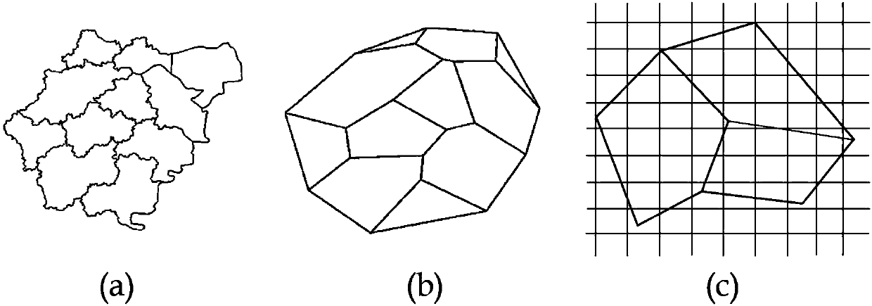
[0046] Refer to Figure 1~ Figure 5 , a geographic map deformation visualization method based on boundary preservation, the visualization method comprising the following steps:

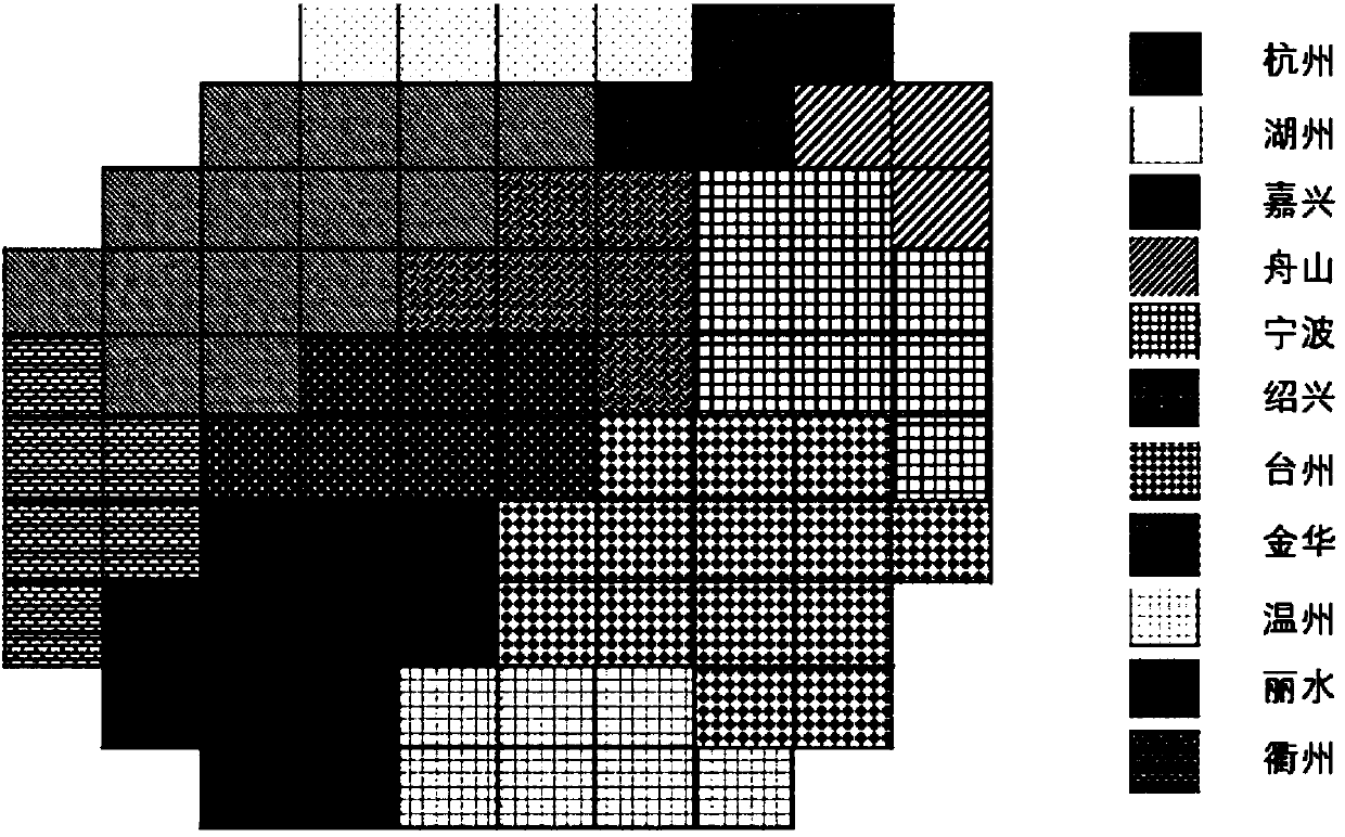
[0047] 1) extracting geographical boundary data: extracting the boundary data of the map, ensuring that the shape of the map generated by the algorithm provided by the present invention is the same as the corresponding position of the region in reality;

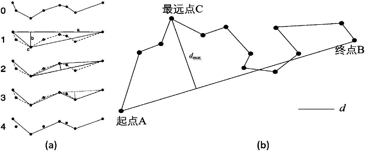
[0048] 2) Map simplification: A simplified map is obtained through the Douglas-Peucker algorithm to reduce distorted points in the original map data. The method is described as follows: 2.1) A straight line AB is connected between two points A and B at the beginning and end of the curve, and the straight line is the chord of the curve; 2.2) The point C on the curve with the largest distance from the straight line segment is obtained, and the...


PUM


Abstract

The invention discloses a geographical map deformation visualization method based on boundary reservation. The method comprises the following steps that: 1) extracting geographical boundary data; 2) carrying out map simplification; 3) mesh generation: adopting a planer mesh generation algorithm to deform a map into a mesh map, and carrying out mesh division on a simplified map in order to guarantee a situation that the map corresponding to a practical geographical area presents a regular shape; 4) block matching: judging areas to which all rectangles belong; and 5) after the above operation isfinished, converting each area into a block formed by a plurality of rectangles, wherein all areas have different colors so as to bring convenience for visual distinguishing. By use of the method, the boundary geographical data of each area of the map is extracted, each area is reconstructed into a rectangular mesh, and in addition, the relative position arrangement of the mesh corresponds to anoriginal geographical position. By use of the method, the problem that a map boundary is irregular is successfully solved, and the geographical boundary of the area is kept.

Description

technical field [0001] The invention relates to a geographic map deformation visualization method based on boundary preservation. Background technique [0002] Spatial visualization has been a major research direction in information visualization and visual analysis. Among them, the map is one of the most common display methods of spatial visualization, which has the characteristics of simplicity and intuition. [0003] With the popularization of GPS, the geographical data and time tag data included in the map have increased dramatically, and the visualization of maps has entered the era of big data. Spatial visualization visually displays spatial information and attribute changes of geographical phenomena, so as to fully understand the development process of complex geographical phenomena, and analyze its development rules to further simulate the changing trend. Therefore, spatial visualization plays an irreplaceable role in fully displaying data. [0004] Spatial inform...

Claims


Application Information

Patent Timeline
Patent Type & Authority Applications(China)
IPC IPC(8): G06F17/30
CPCG06F16/29
Inventor 孙国道周仕幸翟双坡梁荣华
Owner ZHEJIANG UNIV OF TECH
Why Eureka
Try Eureka