Logistics robot, method and controller used for logistics robot, and computer readable medium

A logistics robot and main controller technology, applied in two-dimensional position/channel control, non-electric variable control, control/adjustment system, etc., can solve the problems of large manpower consumption, a large number of manual interventions, and low handling efficiency, and achieve The effect of improving work efficiency and saving labor costs

Inactive Publication Date: 2018-03-16
LINGDONG TECH BEIJING CO LTD
8 Cites 33 Cited by

AI-Extracted Technical Summary

Problems solved by technology

At present, such handling work is mainly carried out by manpower, which not only consumes a lot of manpower, but also has low...

Method used

[0120] For example, in the following mode, the following target is always within the detectable range of the robot, and the known local obstacle avoidance algorithm can be used to plan the route. For example, the main controller can obtain the position information of obstacles and following targets relative to the logistics robot (in the robot coordinate system) at the same time, and perfor...

Abstract

The invention discloses a logistics robot. The logistics robot comprises a removable base, an information acquisition device and a master controller, wherein the information acquisition device is suitable for acquiring image information and depth information of an object existing within a view field of the information acquisition device and/or is suitable for establishing a map of at least one zone by acquiring position information of an object existing in the at least one zone of a logistics place where a robot is located; correspondingly, the master controller is configured to receive information from the information acquisition device, plan a following path of a following target for the robot to follow, and/or plan a navigation path for navigating the robot to the position of a navigation target. According to needs, one or two of a following function and a navigation function can be realized by the logistics robot, and an obstacle avoiding function is also obtained; by utilizing thelogistics robot disclosed by the invention, related operation such as autonomous cargo handling can be carried out under the situation without manual intervention, the labor cost is saved, and the working efficiency is increased.

Application Domain

Position/course control in two dimensions

Technology Topic

Navigation functionMarine navigation +8

Image

  • Logistics robot, method and controller used for logistics robot, and computer readable medium
  • Logistics robot, method and controller used for logistics robot, and computer readable medium

Examples

  • Experimental program(1)

Example Embodiment

[0133] Some possible embodiments of the present invention are given below:
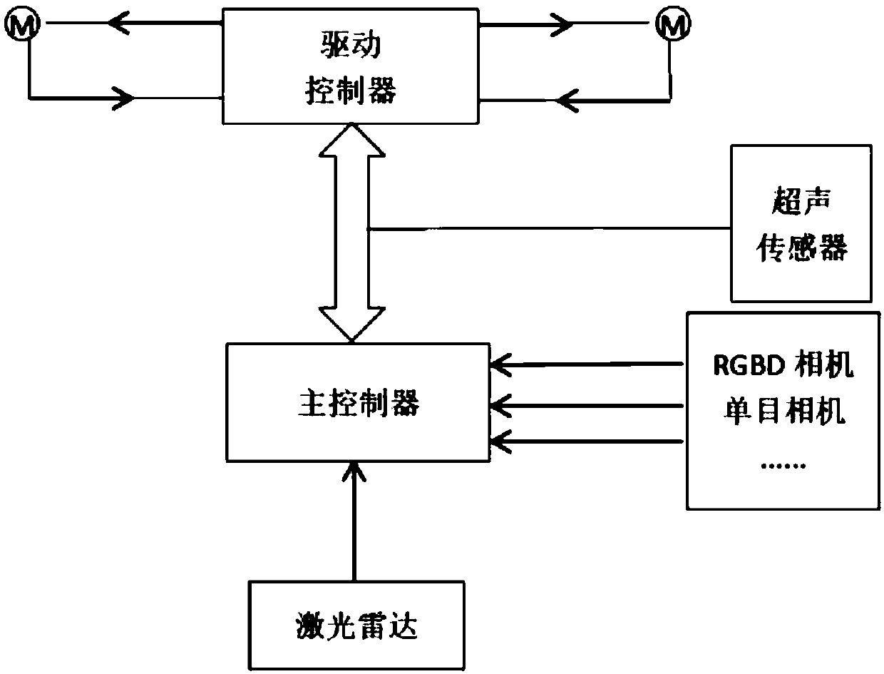
[0134] Scheme 1. A logistics robot, comprising:
[0135] removable base;
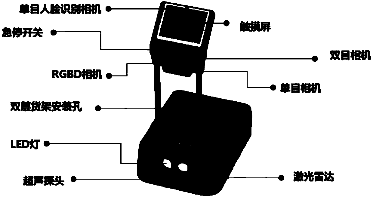
[0136] an information collection device, suitable for collecting image information and depth information of objects existing within its coverage;
[0137] a main controller, coupled to the information collection device, and configured to:
[0138] Acquiring identity information of a following target to be followed by the logistics robot, wherein the following target has an associated identification feature;
[0139] receiving the image information and depth information from the information collection device;
[0140] The image features corresponding to the identification features are extracted from the image information, the image features are matched with the identification features to identify the following target, and based on the following targets captured by the information acquisition device The position in the image determines the direction of the following target relative to the logistics robot, wherein the image information includes the image;
[0141] extracting distance information of the identified following target from the depth information to determine the distance of the following target relative to the logistics robot;
[0142] A following route for the logistics robot to follow the following target is planned based on at least the following target position information including the determined direction and distance, and the movable base is controlled to make the logistics robot travel along the following route.
[0143] Scheme 2. The logistics robot according to scheme 1, wherein the information collection device comprises: an RGBD camera, the RGBD camera is adapted to collect image information and depth information of objects existing within its field of view; and/or a monocular A camera and a lidar, the monocular camera is suitable for collecting image information of objects existing within its field of view, and the lidar is suitable for collecting depth information of objects existing within its field of view.
[0144] Scheme 3. The logistics robot according to scheme 2, wherein the information collection device comprises: the RGBD camera; and, the monocular camera and the lidar, wherein the main controller is configured to:
[0145] Priority is given to obtaining the image information and depth information of the following target from the RGBD camera;
[0146] If the image information and/or depth information of the following target cannot be obtained from the RGBD camera for a predetermined period of time, obtain the image information and depth information of the following target from the monocular camera and the lidar, respectively .
[0147] Scheme 4. The logistics robot according to scheme 3, wherein when the main controller obtains the image information and depth information of the following target from the monocular camera and the lidar, respectively, the main controller is adapted to: At:
[0148] The image features corresponding to the identification features are extracted from the image information, the image features are matched with the identification features to identify the following target, and based on the following targets captured by the monocular camera The position in the image determines the direction information of the following target relative to the logistics robot, wherein the image information includes an image captured by the monocular camera;
[0149] By mapping the direction information to a point map obtained by the lidar, a point in the point map that matches the direction information is determined, and thus the position of the following target relative to the logistics robot is determined. distance information, wherein the depth information includes the spot map;
[0150] The position information of the following target relative to the logistics robot is determined from the determined direction information and distance information as the following target position information, and the following target position information indicates the direction and distance of the following target relative to the logistics robot. .
[0151] Scheme 5. The logistics robot according to scheme 1, wherein the following target is a person authorized to use the logistics robot, and the identification feature includes at least one of the following: the body size of the following target, the back of the following target The job number carried on the camera, the QR code carried on the back of the follower target, and the color of the clothing worn by the follower target.
[0152] Aspect 6. The logistics robot of aspect 1, further comprising an input device for inputting information, wherein the main controller is coupled to the input device and configured to receive the input device from the input device Describe the identity information and/or identifying characteristics of the following target.
[0153] Scheme 7. A logistics robot, comprising:
[0154] removable base;
[0155] A main controller, the main controller is configured to:
[0156] acquiring map information of at least one area of ​​the logistics place where the logistics robot is located, the at least one area includes all or a part of the entire area of ​​the logistics place;
[0157] determining the current location of the logistics robot;
[0158] Get information indicating the location of the navigation target;
[0159] Plan a navigation route for navigating the logistics robot to the navigation target position based on at least the map information, the current position and the information indicating the navigation target position, and control the movable base to make the logistics robot move along the route. the navigation route travels,
[0160] Wherein the at least one area includes the current location and the navigation target location.
[0161] Scheme 8. The logistics robot according to scheme 7, further comprising an information collection device adapted to: collect position information of objects existing in the at least one area; and based on the collected at least one area establishing a map of the at least one area with location information of objects present in Include the map.
[0162] Solution 9. The logistics robot according to solution 8, wherein the information collection device includes a laser radar, and the laser radar is adapted to: collect a laser point cloud of objects existing in the at least one region by scanning the at least one region data, the laser point cloud data indicates the position information of the objects existing in the at least one area; by converting the laser point cloud data into a two-dimensional image, it is determined based on the position information of the objects existing in the at least one area Two-dimensional coordinates of objects existing in the at least one area relative to a predetermined fixed point, thereby establishing a map of the at least one area, wherein the map information includes the relative relationship of the objects existing in the at least one area to the at least one area. The two-dimensional coordinates of the predetermined fixed point.
[0163] Scheme 10. The logistics robot according to scheme 9, wherein the information collection device further comprises a monocular camera, the monocular camera is adapted to capture an image of each feature element in the at least one area, wherein the main The controller is configured to: determine the two-dimensional coordinates of each feature element in the map based on the map and an image of each feature element received from the monocular camera, the feature elements being pre-arranged or from The objects present in the at least one area are selected.
[0164] Scheme 11. The logistics robot according to scheme 9, wherein determining the current position of the logistics robot comprises: matching the information obtained by the real-time scanning of the lidar with the features in the map, and The information obtained by scanning is matched with matching features, and the current position of the logistics robot is determined based on the two-dimensional coordinates of the matching features in the map.
[0165] Scheme 12. The logistics robot according to scheme 9, wherein determining the current position of the logistics robot comprises: determining the travel direction and travel speed of the logistics robot in real time, thereby determining the travel trajectory and the travel path of the logistics robot in the map. Traveling displacement; determining and updating the position of the logistics robot in the map based on the traveling trajectory and the traveling displacement.
[0166] Scheme 13. A logistics robot, comprising:
[0167] removable base;
[0168] a first information collection device, adapted to collect image information and depth information of objects existing within its coverage;
[0169] A main controller, coupled to the first information collection device, and configured to:
[0170] Acquiring identity information of a following target to be followed by the logistics robot, wherein the following target has an associated identification feature;
[0171] receiving the image information and the depth information from the first information collection device;
[0172] The image features corresponding to the identification features are extracted from the image information, the image features are matched with the identification features to identify the following target, and the first information acquisition device based on the following target The position in the captured image determines the orientation of the following target relative to the logistics robot, wherein the image information includes the image;
[0173] extracting distance information of the identified following target from the depth information to determine the distance of the following target relative to the logistics robot;
[0174] planning a following route for the logistics robot to follow the following target based on at least the following target position information including the determined direction and distance, and controlling the movable base to make the logistics robot travel along the following route,
[0175] Wherein, the main controller is further configured to:
[0176] acquiring map information of at least one area of ​​the logistics place where the logistics robot is located, the at least one area includes all or a part of the entire area of ​​the logistics place;
[0177] determining the current location of the logistics robot;
[0178] Get information indicating the location of the navigation target;
[0179] Plan a navigation route for navigating the logistics robot to the navigation target position based on at least the map information, the current position and the information indicating the navigation target position, and control the movable base to make the logistics robot move along the route. the navigation route travels,
[0180] Wherein the at least one area includes the current location and the navigation target location.
[0181] Scheme 14. The logistics robot according to scheme 13, further comprising a second information collection device adapted to: collect position information of objects existing in the at least one area; and based on the collected information establishing a map of the at least one area with location information of objects present in the at least one area, wherein the main controller is coupled to the second information collection device and configured to obtain the information from the second information collection device the map, wherein the map information includes the map.
[0182] Solution 15. The logistics robot according to solution 14, wherein the second information collection device comprises a laser radar, and the laser radar is adapted to: collect laser light of objects existing in the at least one region by scanning the at least one region point cloud data, the laser point cloud data indicating the position information of the objects present in the at least one area; by converting the laser point cloud data into a two-dimensional image, based on the position of the objects present in the at least one area The information determines the two-dimensional coordinates of objects existing in the at least one area relative to a predetermined fixed point, thereby establishing a map of the at least one area, wherein the map information includes the relative relative to the objects existing in the at least one area. the two-dimensional coordinates of the predetermined fixed point.
[0183] Item 16. The logistics robot of Item 15, wherein at least one of the first and second information collection devices includes a monocular camera adapted to capture the at least one area in the an image of each feature element, wherein the main controller is configured to: determine the two-dimensional coordinates of each feature element in the map based on the map and the image of each feature element received from the monocular camera , the feature elements are pre-arranged or selected from objects present in the at least one area.
[0184] Scheme 17. The logistics robot according to scheme 15, wherein determining the current position of the logistics robot comprises: matching the information obtained by the real-time scanning of the lidar with the features in the map, and The information obtained by scanning is matched with matching features, and the current position of the logistics robot is determined based on the two-dimensional coordinates of the matching features in the map.
[0185] Scheme 18. The logistics robot according to scheme 15, wherein determining the current position of the logistics robot comprises: determining the travel direction and travel speed of the logistics robot in real time, thereby determining the travel trajectory and the travel speed of the logistics robot in the map. Traveling displacement; determining and updating the position of the logistics robot in the map based on the traveling trajectory and the traveling displacement.
[0186] Aspect 19. The logistics robot of aspect 1, 7 or 13, further comprising an obstacle avoidance sensor device adapted to detect obstacles and collect information about the obstacles, wherein the main controller is coupled to The obstacle avoidance sensor device is configured to:
[0187] obtain information about obstacles from the obstacle avoidance sensor device;
[0188] Planning the following route or navigation route so that the route bypasses the obstacle, and/or determining whether an obstacle is located on the planned following route or navigation route based on the information about the obstacle and determining whether there is an obstacle When the object is on the planned following route or navigation route, adjust the planned following route or navigation route so that the route bypasses the obstacle,
[0189] The information about the obstacles includes the position information and size information of the detected obstacles.
[0190] Scheme 20. The logistics robot according to scheme 1, 7 or 13, wherein the movable base is provided with at least 3 wheels, at least 2 of the at least 3 wheels are power wheels, and each power wheel is installed in There are drive means for providing driving force to the wheels, a drive controller is mounted in the movable base, the drive controller is coupled to each of the drive means and is coupled to the master controller, wherein the master controller The controller controlling the movable base to make the logistics robot travel along the following route or the navigation route includes: the main controller sends a speed signal for each power wheel to the driving control according to the following route or the navigation route The speed signal indicates the travel speed of each powered wheel that causes the logistics robot to travel along the following route or the navigation route, wherein the drive controller controls each of the driving devices according to the speed signal so that each powered wheel Travel at the appropriate travel speed.
[0191] Solution 21. The logistics robot according to solution 20, wherein 2 of the power wheels are configured as direction control power wheels for controlling the travel direction of the logistics robot, and the 2 direction control power wheels are installed side by side on the Both sides of the base can be moved so that the travel direction of the logistics robot is determined by the difference between the travel speeds of the power wheels in these two directions, and the travel speed of the logistics robot is determined by the sum of the travel speeds of the power wheels in these two directions. Decide.
[0192] Scheme 22. The logistics robot according to scheme 11 or 17, wherein determining the current position of the logistics robot further comprises: in the case of receiving the current position information of the logistics robot, based on the received information of the logistics robot The current location information determines the current location of the logistics robot.
[0193] Item 23. The logistics robot according to item 11 or 17, wherein the information collection device comprises a monocular camera, the monocular camera is adapted to capture an image of each feature element in the at least one area, the feature Elements are pre-arranged or selected from objects present in the at least one area, wherein the main controller is configured to: determine each feature element based on the map and an image of each feature element received from the monocular camera. The two-dimensional coordinates of the feature elements in the map,
[0194] Wherein determining the current position of the logistics robot further includes: matching the image captured by the monocular camera in real time with the feature elements, and when recognizing the matching feature elements matching the image captured by the monocular camera in real time, based on The two-dimensional coordinates of the matching feature elements in the map determine the current position of the logistics robot.
[0195] Scheme 24. The logistics robot according to scheme 12 or 18, wherein determining the current position of the logistics robot further comprises: matching the information obtained by real-time scanning of the lidar with the features in the map, and after identifying the map When there is a matching feature that matches the information obtained by the lidar scanning, the travel displacement determined based on the two-dimensional coordinates of the matching feature in the map is calibrated, and the travel path determined based on the travel trajectory and travel displacement is calibrated. The location of the logistics robot in the map.
[0196] Item 25. The logistics robot according to Item 12 or 18, wherein the information collection device further comprises a monocular camera, the monocular camera is adapted to capture an image of each feature element in the at least one area, the feature elements are pre-arranged or selected from objects present in the at least one area, wherein the main controller is configured to: determine based on the map and an image of each feature element received from the monocular camera the two-dimensional coordinates of each feature element in the map,
[0197] Wherein determining the current position of the logistics robot further includes: matching the image captured by the monocular camera in real time with the feature elements, and when recognizing the matching feature elements matching the image captured by the monocular camera in real time, based on The two-dimensional coordinates of the matching feature elements in the map calibrate the determined travel displacement, and calibrate the position of the logistics robot in the map determined based on the travel trajectory and the travel displacement.
[0198] Scheme 26. The logistics robot according to scheme 12 or 18, wherein determining the current position of the logistics robot further comprises: acquiring continuous images acquired by a camera in real time; for every two consecutive images within a period of time: extracting the a same feature point, the same feature point is mapped to the same coordinate system to determine the speed vector of the same feature point; based on the series of speed vectors thus obtained, the travel of the logistics robot within the period of time is calculated displacement; determine the current position of the logistics robot based on the calculated travel displacement and the position information of the logistics robot at the beginning of the period of time; calibrate the current position of the logistics robot determined by using the thus determined and calibrate the position of the logistics robot in the map determined based on the travel trajectory and the travel displacement.
[0199] Aspect 27. The logistics robot of aspect 1, 7 or 13, wherein the logistics robot further comprises a lighting device coupled to the main controller and selectively enabled and disabled by the main controller use.
[0200] Aspect 28. The logistics robot according to Aspect 1, 7 or 13, further comprising: at least one post extending upward from the movable base; and a control panel mounted above the movable base through the at least one post .
[0201] Solution 29. The logistics robot according to solution 28, wherein an emergency stop switch is installed on the control panel for braking the logistics robot in an emergency, the main controller is coupled to the emergency stop switch, and is configured to brake the movable base when the emergency stop switch is activated, thereby braking the logistics robot.
[0202] Aspect 30. The logistics robot according to Aspect 1, 7 or 13, further comprising an additional shelf above the movable base and spaced apart from the movable base, the additional shelf being adapted to carry goods.
[0203] Option 31. The logistics robot of option 30, wherein the additional rack is mounted to the logistics robot through the at least one post; or, wherein the logistics robot further comprises at least one extending upwardly from the movable base an additional pillar, the additional pillar is adapted to be mounted to the movable base through the mounting holes reserved on the movable base, and the shelf is mounted to the movable base through the at least one pillar and the at least one additional pillar Logistics robot.
[0204] Aspect 32. The logistics robot of Aspect 19, wherein the obstacle avoidance sensor device comprises a plurality of ultrasonic sensors arranged on each side of the movable base.
[0205] Item 33. The logistics robot of Item 32, wherein two ultrasonic sensors are arranged on each side of the movable base.
[0206] Item 34. The logistics robot according to Item 3, 9 or 15, wherein the lidar is mounted on the front and/or rear and/or sides of the movable base.
[0207] Item 35. The logistics robot according to Item 34, wherein the lidar is installed in a groove provided on the front and/or rear and/or side of the movable base.
[0208] Scheme 36. A method for a logistics robot having a movable base, comprising:
[0209] Acquiring identity information of a following target to be followed by the logistics robot, wherein the following target has an associated identification feature;
[0210] Receive image information and degree information from an information acquisition device that collects image information and depth information of objects existing within its coverage area;
[0211] The image features corresponding to the identification features are extracted from the image information, the image features are matched with the identification features to identify the following target, and based on the following targets captured by the information acquisition device The position in the image determines the direction of the following target relative to the logistics robot, wherein the image information includes the image;
[0212] extracting distance information of the identified following target from the depth information to determine the distance of the following target relative to the logistics robot; and
[0213] A following route for the logistics robot to follow the following target is planned based on at least the following target position information including the determined direction and distance, and the movable base is controlled to make the logistics robot travel along the following route.
[0214] Scheme 37. A method for a logistics robot having a movable base, comprising:
[0215] acquiring map information of at least one area of ​​the logistics place where the logistics robot is located, the at least one area includes all or a part of the entire area of ​​the logistics place;
[0216] determining the current location of the logistics robot;
[0217] obtain information indicating the location of the navigation target; and
[0218] Plan a navigation route for navigating the logistics robot to the navigation target position based on at least the map information, the current position and the information indicating the navigation target position, and control the movable base to make the logistics robot move along the route. the navigation route travels,
[0219] Wherein the at least one area includes the current location and the navigation target location.
[0220] Option 38. The method of Option 37, wherein determining the current location of the logistics robot comprises:
[0221] Match the information obtained by the real-time scanning of the lidar installed on the movable base with the features in the map, identify the matching features in the map that match the information scanned by the lidar, and based on the matching features The two-dimensional coordinates in the map determine the current location of the logistics robot; and/or
[0222] Determine the travel direction and travel speed of the logistics robot in real time, thereby determining the travel trajectory and travel displacement of the logistics robot in the map; determine and update the logistics robot in the map based on the travel trajectory and travel displacement s position.
[0223] Scheme 39. A controller for a logistics robot having a moveable base, the controller comprising a memory and a processor, wherein the memory has stored thereon computer instructions that when executed by the processor cause The controller performs the steps of the method according to any of aspects 36-38.
[0224] Scheme 40. A computer-readable storage medium having stored thereon computer instructions that, when executed by one or more processors of a logistics robot having a movable base, implement according to scheme 36- The steps of any one of 38.

PUM

no PUM

Description & Claims & Application Information

We can also present the details of the Description, Claims and Application information to help users get a comprehensive understanding of the technical details of the patent, such as background art, summary of invention, brief description of drawings, description of embodiments, and other original content. On the other hand, users can also determine the specific scope of protection of the technology through the list of claims; as well as understand the changes in the life cycle of the technology with the presentation of the patent timeline. Login to view more.

Similar technology patents

Automatic rice seedling taking and feeding transplanter

Owner:巴州鑫茂林工贸有限责任公司

System and method for translation

InactiveCN103823796AImprove translation accuracyReduce labor costs
Owner:IOL WUHAN INFORMATION TECH CO LTD

Unattended intelligent shopping method and self-service shopping cabinet

InactiveCN107633600AReduce labor costsEasy to observe and choose
Owner:DEEPBLUE TECH SHANGHAI CO LTD

Cargo taking robot

Owner:YUNJI ERA IND DESIGN YIWU CO LTD

Classification and recommendation of technical efficacy words

  • Reduce labor costs
  • Improve work efficiency

Cooperation service platform facing different source data

InactiveCN101174957AImprove management level and qualityImprove work efficiency
Owner:NANJING UNIV OF FINANCE & ECONOMICS

Screw drilling tool, vertical drilling tool testing method and well inclination simulation testing equipment

InactiveCN111594144AReduced height requirementsImprove work efficiency
Owner:DEZHOU UNITED GASOLINEEUM MACHINERY

Method for intelligent automatic identification of transmission circuit parts

Owner:INFORMATION COMM COMPANY STATE GRID SHANDONG ELECTRIC POWER +2

Keyboard spill-proofing mechanism

ActiveUS7030330B2minimize manufacturing costimprove work efficiency
Owner:LITE ON SINGAPORE PTE LTD
Why Eureka
Try Eureka