Multi-satellite and multi-ground station resource collaborative allocation management method oriented to region target

A technology of regional goals and management methods, applied in the directions of radio transmission systems, electrical components, transmission systems, etc., can solve the problems of inability to apply regional goals and affect the efficient use of earth observation satellite system resources, to simplify the complexity, maximize the shortest Time response mechanism, the effect of improving resource utilization

Active Publication Date: 2018-03-30
陕西丝路天图卫星科技有限公司
View PDF15 Cites 26 Cited by
  • Summary
  • Abstract
  • Description
  • Claims
  • Application Information

AI Technical Summary

Problems solved by technology

Therefore, this method cannot be applied to regional targets, which affect

Method used


Image

  • Multi-satellite and multi-ground station resource collaborative allocation management method oriented to region target
  • Multi-satellite and multi-ground station resource collaborative allocation management method oriented to region target
  • Multi-satellite and multi-ground station resource collaborative allocation management method oriented to region target

Examples


Embodiment 1

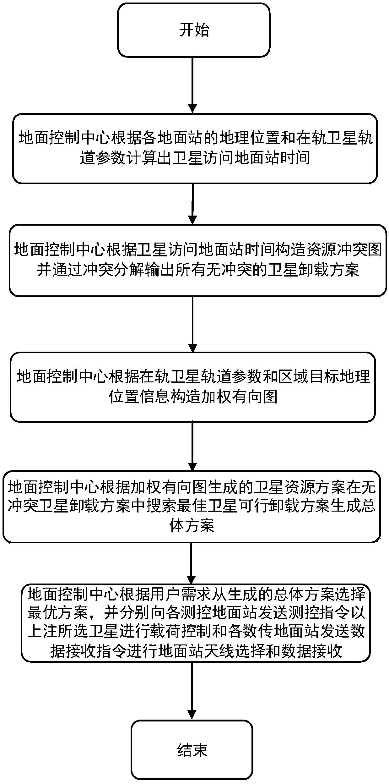
[0029] This example sets out from the earth observation satellite system to illustrate the implementation process of the present invention. refer to figure 1 , the earth observation satellite system used in the present invention includes a ground control center, an earth observation satellite and a ground station part. It is assumed that the earth observation satellite system consists of I satellites distributed in sun-synchronous orbits. Each earth observation satellite is equipped with H sensors with different resolutions. The roll angle range of each sensor is [-30°, 30°]. Assuming that the number of ground stations is M, and the stations are deployed locally, each ground station is equipped with n transceiver devices. The geographic location of the target area is randomly generated globally.

[0030] In previous studies, most of the research work on resource management of the earth observation satellite system only considered the earth observation or data offloading st...

Embodiment 2

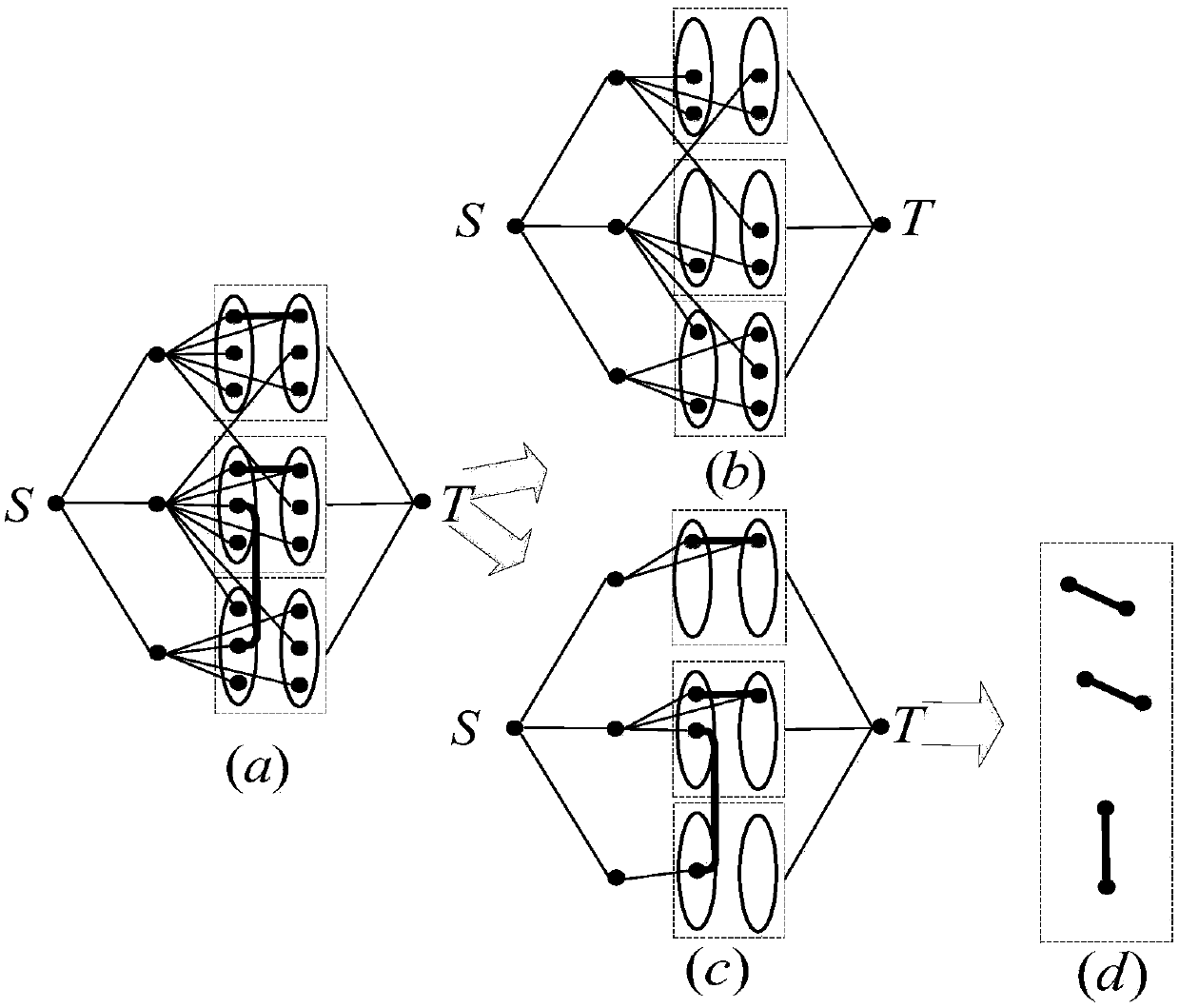
[0042] The regional target-oriented multi-star multi-ground station resource collaborative allocation management method is the same as embodiment 1, and the construction resource relationship diagram described in step (2) specifically includes:

[0043] (2a) Construct resource relationship graph G 1 The point set V(G 1 )={S}∪{T}∪N∪S at , where S is the virtual source node, T is the virtual destination node, is the set of ground station virtual points, S at is a collection of satellite nodes, It is the opportunity for the j-th satellite to visit the n-th set of transceiver equipment of the m-th ground station for the i-th time.

[0044] (2b) Construct resource relationship graph G 1 The edge set E(G 1 ), namely E(G 1 )=SS∪SG∪NT∪CV, where SS is the virtual source node S to satellite node S i ∈ S at The edge set of , SG is the construction satellite node S i ∈ S at The edge set to the virtual point set N of the ground station, NT is the virtual node for constructing ...

Embodiment 3

[0046] The regional target-oriented multi-star multi-ground station resource cooperative allocation management method is the same as embodiment 1-2, and the ground control center described in step (3) builds a communication resource conflict-free graph and a communication resource conflict graph, specifically including:

[0047] (3a) Resource relationship graph G of accessing ground stations from satellites 1 Delete the conflicting edge and the points connected to the conflicting edge to get the communication resource conflict-free graph G 2 (V(G 2 ),E(G 2 )). Access to ground station resource diagram G from satellite 1 Deletion of communication resources in conflict-free graph G 2 The set of all nodes and edges except the satellite node, virtual source node and destination node in , can get the resource graph G with conflict relationship 3 =G 3 (V(G 3 ),E(G 3 )).

[0048] (3b) will have a resource graph G with conflicting relations 3 Middle side E(G 3 )\CV is expre...


PUM


Abstract

The invention discloses a multi-satellite and multi-ground station resource collaborative allocation management method oriented to a region target. The multi-satellite and multi-ground station resource collaborative planning problem is solved. The realization process is as follows: respectively constructing resource relation graphs, communication resource conflict-free graphs and communication resource conflict graphs through a ground control center by acquiring the ground station and satellite information, thereby generating a satellite unloading scheme; computing a satellite access region target by using the target region information and the satellite ephemeris, extracting all possible and feasible satellite unloading schemes from the satellite unloading scheme; constructing a weighted directed graph for each feasible satellite unloading scheme, traversing all weighted direction graphs, and finding out a path with large coverage rate and less hop count by using a labelling algorithmand a defined addition, thereby generating a total unloading scheme and annotating a measurement and control instruction. Through the method disclosed by the invention, the resource use ratio and thetask planning efficiency are improved, the complexity of the resource management is reduced, and the method can be used for the resource management of the ground observation satellite system.

Description

technical field [0001] The invention belongs to the field of space information technology, and mainly relates to the coordinated allocation and management of resources of satellites and ground stations, in particular to a resource management method for coordinated allocation of multi-satellite and multi-ground stations oriented to coverage area targets, which can be used for the tasks of the earth observation satellite system Planning and Scheduling. Background technique [0002] The earth observation satellite system is an important infrastructure in my country, and its main working process mainly includes two stages of earth observation and data offloading. Specifically, the ground image information is obtained by observing various sensors equipped on the satellite, and then unloaded to the ground station. However, the contradiction between the rapidly increasing demand for observation tasks and the scarcity of resources such as observation satellites and ground stations ...

Claims


Application Information

Patent Timeline
IPC IPC(8): H04B7/185
CPCH04B7/18519
Inventor 盛敏何立军刘润滋李建东汪宇周笛朱彦贾子晔刘建平李晶
Owner 陕西丝路天图卫星科技有限公司
Why Eureka
Try Eureka