A method for judging the positioning area of ​​underground UWB multi-base stations based on ads-twr

A technology of positioning area and judgment method, which is applied in the direction of location information-based service, connection management, advanced technology, etc., can solve the problems of large and invalid communication, and achieve the effect of reducing node power consumption, reducing time, and high real-time positioning

Active Publication Date: 2020-03-17
HEFEI UNIV OF TECH
View PDF7 Cites 2 Cited by
  • Summary
  • Abstract
  • Description
  • Claims
  • Application Information

AI Technical Summary

Problems solved by technology

[0005] The purpose of the present invention is to provide an ADS-TWR-based underground UWB multi-base station positioning area determination method to solve the problem of a large number of invalid communications caused by mobile tags broadcasting Poll request frames in underground UWB multi-base station positioning

Method used


Image

  • A method for judging the positioning area of ​​underground UWB multi-base stations based on ads-twr
  • A method for judging the positioning area of ​​underground UWB multi-base stations based on ads-twr
  • A method for judging the positioning area of ​​underground UWB multi-base stations based on ads-twr

Examples


Embodiment Construction

[0039] The present invention will be further described below in conjunction with accompanying drawing:

[0040] Such as Figure 1-6 As shown, an ADS-TWR-based downhole UWB multi-base station positioning area determination method, the specific steps are as follows:

[0041] S1: Multi-base station equidistant distribution:

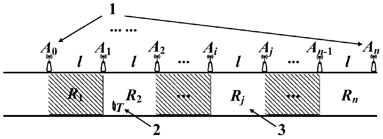
[0042] According to the communication distance between the ranging base station and the UWB mobile tag, multiple ranging base stations are distributed at equal intervals on one side of the underground roadway wall according to the size not greater than the communication distance, and kept at the same level, every two adjacent The ranging base station determines an area R j ;

[0043] Such as figure 1 As shown, for example, there are multiple UWB ranging base stations A0~An, and all ranging base stations are equally spaced on one side of the underground roadway wall. Assuming that the communication distance between the ranging base station and the mobile ...


PUM


Abstract

The invention discloses a downhole UWB multi-basestation location zone determining method based on ADS-TWR, adopts an ultra wideband communication technology and an asymmetric double sided two-way range algorithm, and introduces a "zone determination" and "zone correction" mechanism to reduce the location complexity in the downhole multi-basestation location. In the method, not all the distance ranging base stations are requested to be connected at each time of location; firstly, the zone of a mobile tag is precisely determined by using a high-precision ranging advantage of the ADS-TWR algorithm; and then, the UWB communication is only built among the ranging base stations located in the zone when locating. Thus, the problem that plenty of invalid communication is generated when the mobiletag broadcasts the Pill request frame at each time of location is solved; the time for acquiring a group of ranging information by an upper computer is greatly reduced. Meanwhile, the method reducesthe node power consumption, and provides assurance for realizing high-precision and high real-time location.

Description

technical field [0001] The invention relates to the technical field of mobile wireless communication and location services, in particular to an ADS-TWR-based underground UWB multi-base station positioning area determination method. Background technique [0002] With the continuous development of industrial Internet of Things and artificial intelligence technology in the field of coal mines, the location information of personnel and equipment in coal mines has become very important basic information. At present, wireless technologies such as RFID, WiFi, ZigBee, and Bluetooth are mostly used to locate objects under mine roadways, but due to problems such as poor positioning accuracy, they cannot meet the requirements of high-precision underground positioning. Ultra Wideband (UWB) technology has the characteristics of high time resolution, strong penetrating power, anti-multipath weakening ability and anti-interference ability, and can effectively overcome the defects of tradit...

Claims


Application Information

Patent Timeline
Patent Type & Authority Patents(China)
IPC IPC(8): H04W4/02H04W4/021H04W16/18H04W64/00H04W76/40
CPCH04W4/021H04W4/023H04W16/18H04W64/00Y02D30/70
Inventor 陆阳方文浩卫星张建军魏振春毕翔陶稳静贾向利高健
Owner HEFEI UNIV OF TECH
Why Eureka
Try Eureka