Remote sensing monitoring method and system for rice planting area

A remote sensing monitoring and rice technology, applied in the field of agricultural remote sensing, can solve the problems of low accuracy and slow identification of rice planting areas, and achieve the effects of fast and accurate identification and high ratio vegetation index.

Active Publication Date: 2018-04-27
SUZHOU ACADEMY OF AGRI SCI
View PDF4 Cites 12 Cited by
  • Summary
  • Abstract
  • Description
  • Claims
  • Application Information

AI Technical Summary

Problems solved by technology

[0004] The purpose of the present invention is to provide a remote sensing monitoring method and system for rice planting area to solve the problems of slow identification speed and low precision of rice planting area

Method used


Image

  • Remote sensing monitoring method and system for rice planting area
  • Remote sensing monitoring method and system for rice planting area

Examples


Embodiment 1

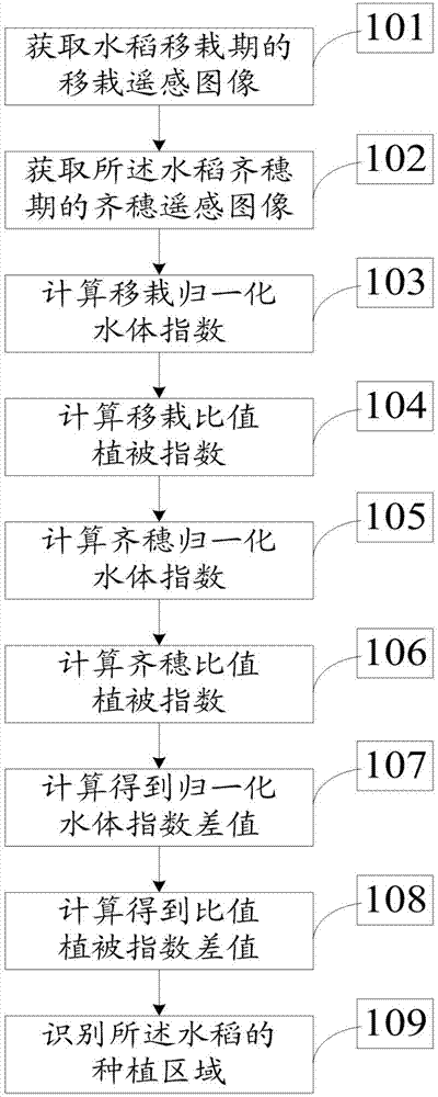
[0085] As shown in Example 1, the distribution data of rice planting areas in Suzhou High-tech Zone comes from the digitized 1:25000 scale land use status map in 2016 (provided by Suzhou Zhongke Tianqi Remote Sensing Technology Co., Ltd.), the classification accuracy is greater than 95%, based on 2015 The 0.8-meter image data source of Nian Gaofen-2 was obtained; at the same time, Google earth high-resolution remote sensing data (0.5 m) and field survey sampling information in the research area were used as ground verification data for remote sensing classification in this study, which were used for training samples and Selection of test samples for classification results. At the tillering stage, rice is in a flooded state, and NDWI shows a positive value, and the NDVI and RVI values ​​of rice are significantly lower than those of other vegetation (woodland, etc.); at the full heading stage, the rice field has no water coverage, and NDWI shows a negative value, and the NDVI and...


PUM


Abstract

The invention discloses a remote sensing monitoring method for the rice planting area. The method comprises steps that remote sensing transplanting images at the rice transplanting stage and remote sensing full heading images at the full heading stage are acquired; a transplanting normalized water index is calculated according to the remote sensing transplanting images; a transplanting ratio vegetation index is calculated according to the remote sensing transplanting images; a full heading normalized water index is calculated according to the remote sensing full heading images; a full headingratio vegetation index is calculated based on the remote sensing full heading images; normalized water index difference is calculated according to the transplanting normalized water index and the fullheading normalized water index; ratio vegetation index difference is calculated according to the transplanting ratio vegetation index and the full heading ratio vegetation index; space-crossing operation is utilized to identify planting areas of the rice according to the normalized water index difference and the ratio vegetation index difference. The method is advantaged in that the rice plantingareas can be rapidly and accurately identified.

Description

technical field [0001] The invention relates to the technical field of agricultural remote sensing, in particular to a remote sensing monitoring method and system for rice planting area. Background technique [0002] Accurate acquisition of rice planting area is crucial to the accurate evaluation of rice economic and ecological functions. In recent years, remote sensing monitoring technology has been widely used in the extraction of rice area due to its advantages of high efficiency, objectivity and economy. [0003] In the prior art, extracting time-series vegetation index based on rice phenological characteristics is the most effective method to identify rice planting areas, but it requires a large number of remote sensing images as data support. However, in the eastern coastal areas, the rice growing season coincides with the cloud and rainy season, cloud pollution and other factors affect the acquisition of high-quality remote sensing images, which often leads to the lac...

Claims


Application Information

Patent Timeline
Patent Type & Authority Applications(China)
IPC IPC(8): G01B11/28G06K9/00
CPCG01B11/285G06V20/188
Inventor 张海东张青田婷陈妮
Owner SUZHOU ACADEMY OF AGRI SCI
Why Eureka
Try Eureka