An indoor positioning method, a navigation method and a system

An indoor positioning and inertial navigation system technology, applied in the field of analysis and measurement control, can solve the problems of cumulative error of INS guidance mode, large non-line-of-sight error, and high cost of high-precision INS devices

Inactive Publication Date: 2018-05-15
云保(佛山)智控科技有限公司
View PDF6 Cites 37 Cited by
  • Summary
  • Abstract
  • Description
  • Claims
  • Application Information

AI Technical Summary

Problems solved by technology

[0009] The embodiment of the present application provides an indoor positioning method, a navigation method and a system, which are used to solve the accumulated errors in the INS guidance method in the prior art, the high cost of high-precision INS devices, and the large non-line-of-sight error in the UWB (ultra-wideband) positioning method. The problem

Method used


Image

  • An indoor positioning method, a navigation method and a system
  • An indoor positioning method, a navigation method and a system
  • An indoor positioning method, a navigation method and a system

Examples


Embodiment 1

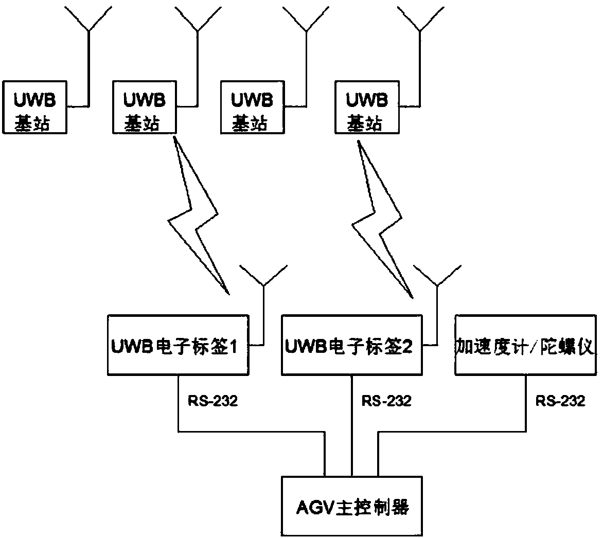
[0043] like figure 1As shown, it is a schematic structural diagram of the indoor positioning system provided in Embodiment 1 of the present application. The system includes an automatic guided vehicle AGV and at least 3 UWB base stations, wherein the AGV includes a main controller, an inertial navigation system INS and at least 2 UWB electronic tags:

[0044] INS is used to calculate the first positioning data and first attitude data of the AGV according to the three-axis angular velocity and three-axis acceleration values ​​measured by the integrated three-axis gyroscope and three-axis accelerometer;

[0045] The first positioning data of the above-mentioned AGV is the position data of the AGV obtained from the INS system. Here, in order to distinguish it from the position data of the AGV obtained based on the distance data between the UWB electronic tag obtained by the UWB electronic tag and each UWB base station, it will be obtained from The position data of the AGV obtain...

Embodiment 2

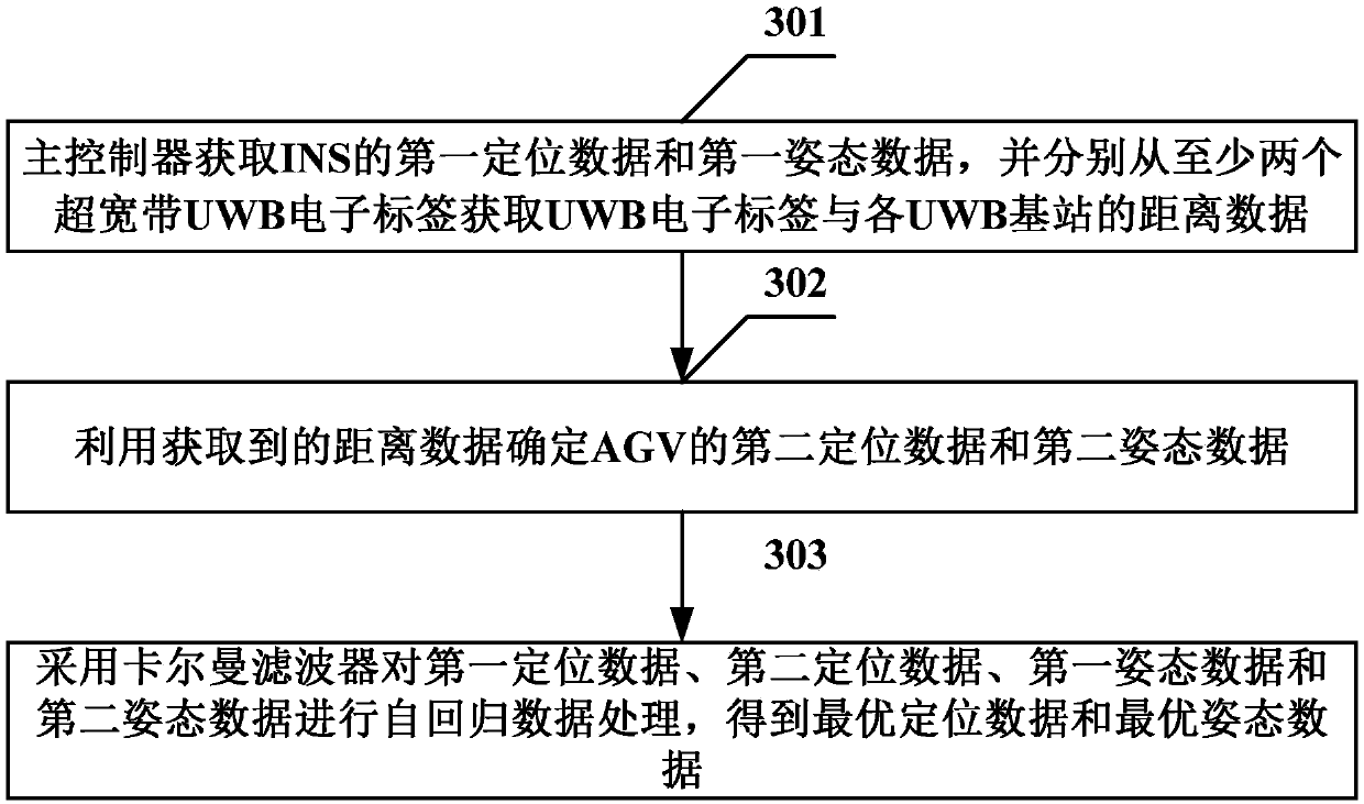
[0060] like image 3 As shown, it is a flow chart of the indoor positioning method provided in Embodiment 2 of the present application. This method is applied to the automatic guided transport vehicle AGV, and the AGV includes a main controller, an inertial navigation system INS and at least 2 UWB electronic tags, The method includes the following steps:

[0061] Step 301: the main controller obtains the first positioning data and the first attitude data from the INS, and respectively obtains the distance data between the UWB electronic tag and each UWB base station from at least two ultra-wideband UWB electronic tags;

[0062] Step 302: Using the acquired distance data to determine the second positioning data and the second attitude data of the AGV;

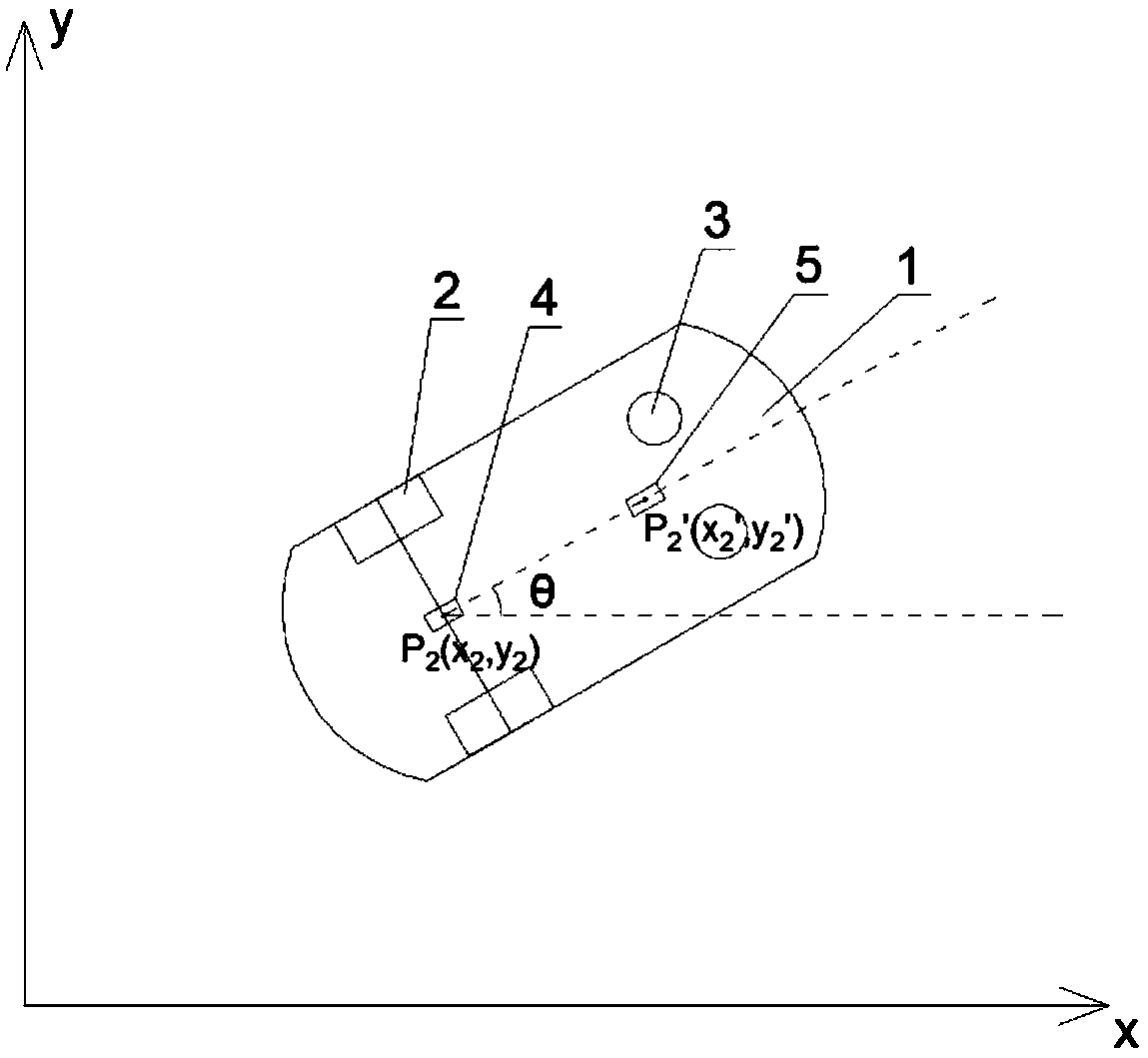
[0063] Preferably, the number of UWB electronic tags is 2, and the 2 UWB electronic tags are installed one after the other on the central axis of the AGV's movement direction, and at least one is installed at the central point ...

Embodiment 3

[0071] Based on the same inventive concept as that of Embodiment 1 and Embodiment 2, Embodiment 3 of the present application provides an indoor navigation system, its structural diagram is as follows Figure 5 As shown, the system includes: AGV and at least 3 UWB base stations, wherein the AGV includes a main controller, INS and at least 2 UWB electronic tags:

[0072] INS is used to calculate the first positioning data and first attitude data of the AGV according to the three-axis angular velocity and three-axis acceleration values ​​measured by the integrated three-axis gyroscope and three-axis accelerometer;

[0073] UWB electronic tags are used to communicate with UWB base stations arranged around, and use communication data to calculate the distance to each UWB base station;

[0074] The main controller is used to obtain the first positioning data and the first attitude data from the INS, and obtain the distance data between the UWB electronic tag and each UWB base statio...


PUM


Abstract

An indoor positioning method, a navigation method and a system are provided in embodiments of the invention to overcome a problem that an accumulated error/non-line-of-sight error in the prior art ishigh. The indoor positioning method is applied for an automatic guided vehicle (AGV). The AGV includes a main controller, an inertial navigation system (INS) and at least two UWB electronic tags. Themethod includes acquiring, by the main controller, first positioning data and first attitude data from the INS; acquiring data about a distance between the UWB electronic tags and each UWB base station from the at least two ultra wide band (UWB) electronic tags; determining second positioning data and second attitude data of the AGV by utilizing the acquired distance data; and subjecting the firstand second positioning data and the first and second attitude data to autoregression data processing by utilizing Kalman filters to obtain optimum positioning data and optimum attitude data. Accuratepositioning data can be obtained by the method so as to obtain navigation information, and an ideal navigation precision can be obtained by utilizing a cheap device.

Description

technical field [0001] The present application relates to the technical field of analysis and measurement control, and in particular to an indoor positioning method, navigation method and system. Background technique [0002] At present, AGV (Automated Guided Vehicle) guidance methods are mainly divided into fixed path guidance and free path guidance. Fixed path guidance includes: electromagnetic guidance, tape guidance, and optical guidance. Currently, fixed path guidance methods and relatively It is mature and the cost is relatively low, especially the tape-guided method is the most widely used. [0003] Although the fixed path guided AGV has the advantages of mature technology, high reliability, and low cost, its shortcomings are also very prominent. Poor flexibility is one of its main disadvantages. AGV can only run along fixed paths such as tapes, and changing the route requires re-laying the guiding medium. Moreover, the laid guide medium is often damaged due to the ...

Claims


Application Information

Patent Timeline
Patent Type & Authority Applications(China)
IPC IPC(8): G01C21/16G01C21/20
Inventor 茅健杨慧斌闫娟
Owner 云保(佛山)智控科技有限公司
Why Eureka
Try Eureka