A method based on deep learning to obtain the position and attitude of the image city

A technology for acquiring images and deep learning, which is applied in the field of acquiring the position and attitude of images within the city based on deep learning, can solve the problem of time-consuming calculation process of RANSAC, and achieve the effect of enriching the location information of pictures and reducing costs.

Active Publication Date: 2020-07-31
XIAMEN UNIV
View PDF6 Cites 0 Cited by
  • Summary
  • Abstract
  • Description
  • Claims
  • Application Information

AI Technical Summary

Problems solved by technology

Although the accuracy of coordinate regression forest is very high, its disadvantage is mainly that RGB-D images are required as input. In actual use, RGB-D images are only suitable for indoor scenes, and the RANSAC calculation process is very time-consuming.

Method used


Image

  • A method based on deep learning to obtain the position and attitude of the image city
  • A method based on deep learning to obtain the position and attitude of the image city
  • A method based on deep learning to obtain the position and attitude of the image city

Examples


Embodiment Construction

[0043] Below in conjunction with embodiment and accompanying drawing, further illustrate the present invention.

[0044] 1. Overall process design of the invention

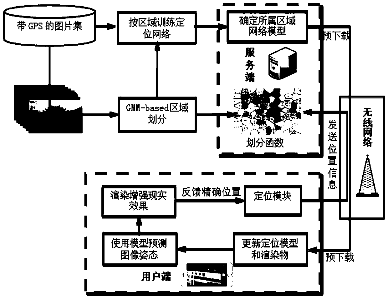
[0045] The present invention designs an implementation system based on deep learning to obtain the position and attitude of the image within the city range on the PC side. The frame diagram is as follows figure 1 shown. The whole invented system is divided into online part and online part. The offline part is mainly on the server side. The training area division learner divides the whole city into sub-areas, and then uses the migration learning method to train the proposed pose regression and scene classification network for each sub-area. The online part is mainly on the mobile client. After the user arrives in a certain area, the server sends the GPS or the geographical location of the mobile phone base station to the server. The server determines the area (scenario) to which the user belongs according to the ...


PUM


Abstract

A method based on deep learning to obtain the position and attitude of an image within a city, involving the field of image location recognition and augmented reality. The method includes the following steps: 1) creating a city picture set; 2) training a mixed Gaussian model on the city picture set, and using the trained mixed Gaussian model to divide urban geographical regions; 3) training a joint learning picture pose estimation and scene recognition neural network; 4) Initialize, upload the user's GPS or network rough location information; 5) use the learned division function to divide the rough location information, download the corresponding network model and the rendering data to be displayed to the client; 6) collect the user input camera video stream, Use the downloaded network model of the current area to predict the positioning results of the three levels at the current moment. If the confidence of the prediction result output by the network is higher than the threshold, the rendered data will be rendered using the predicted position and attitude parameters.

Description

technical field [0001] The invention relates to the field of image geographic location recognition and augmented reality, in particular to a method for obtaining the location and posture of an image within a city range based on deep learning. Background technique [0002] With the explosive development of mobile Internet and smart devices, taking and sharing photos has become a part of people's daily life. How to deduce from the photo where the photo was taken and the perspective of the photo has become a very meaningful problem. The problem of inferring the shooting position and perspective from the photo is also called the pose estimation problem of the camera in Multi-View Stereo. It is a basic problem in the field of computer vision and robotics, and has a wide range of applications, such as enhancing Reality (Augmented Reality, referred to as AR), simultaneous positioning and map construction (Simultaneous Localization and Mapping, referred to as SLAM), and image-based...

Claims


Application Information

Patent Timeline
Patent Type & Authority Patents(China)
IPC IPC(8): G06T3/00G06T7/73G06N3/08G06K9/62
CPCG06N3/08G06T3/0012G06T7/73G06F18/23
Inventor 纪荣嵘郭锋黄剑波
Owner XIAMEN UNIV
Why Eureka
Try Eureka