Map data processing method and device

A technology of map data and processing methods, which is applied in the direction of electronic digital data processing, special data processing applications, geographic information databases, etc., can solve the problems of high redundancy of map data and low efficiency of reading and writing map data, and reduce redundancy Speed, improve read and write efficiency, reduce the effect of data coupling

Active Publication Date: 2018-07-03
NAVINFO
View PDF12 Cites 21 Cited by
  • Summary
  • Abstract
  • Description
  • Claims
  • Application Information

AI Technical Summary

Problems solved by technology

[0005] Therefore, the technical problem to be solved by the present invention is that the redundancy of map data in the prior art is high, and the reading and writing efficiency of map data is low.

Method used


Image

  • Map data processing method and device
  • Map data processing method and device
  • Map data processing method and device

Examples


Embodiment 1

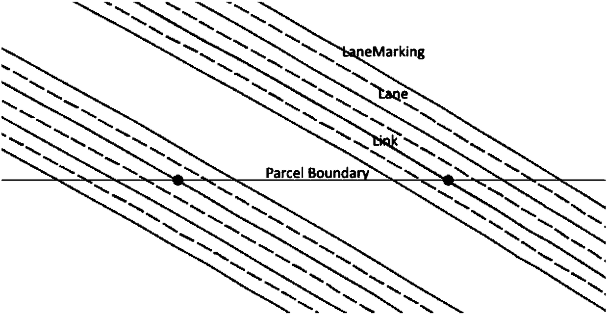
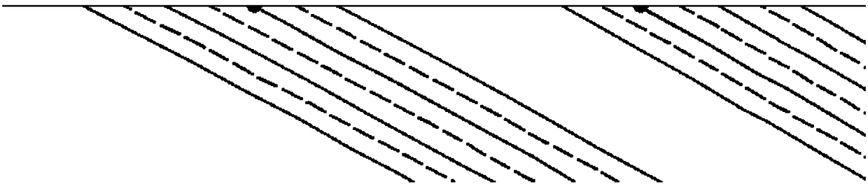
[0034] This embodiment provides a map data processing method, which is applicable to the processing of high-precision map data whose minimum road unit is a lane. For the convenience of description, the names appearing in this embodiment are described as follows:

[0035] Link represents a road (ie road line) in the actual road network;

[0036] LinkID indicates the absolute number of the Link in a certain grid of the electronic map;

[0037] Lane represents a lane (ie lane line) in a road in the actual road network;

[0038] Lane Marking means the sideline of the lane;

[0039] Node represents the endpoint of a Link or Lane in the electronic map;

[0040] Parcel represents a grid of the segmented electronic map;

[0041] Region represents a grid in the topological relationship data of the segmented electronic map;

[0042] PID represents the number that uniquely identifies Parcel;

[0043] (x, y) represent geographic coordinates.

[0044] Such as image 3 As shown, a map ...

Embodiment 2

[0067] This embodiment provides a map data processing device, which is suitable for the processing of high-precision map data whose minimum road unit is a lane, such as Figure 9 As shown, the device includes: a first acquisition module 91, a judgment module 92, a second acquisition module 93, a calculation module 94 and a segmentation module 95, and the main functions of each module are as follows:

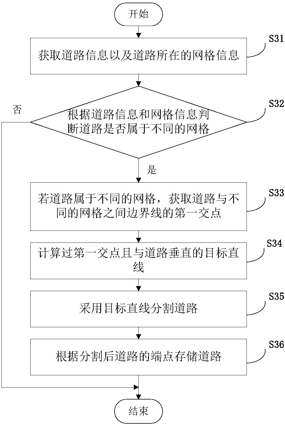
[0068] The first acquisition module 91 is configured to acquire road information and grid information where the road is located. For details, refer to the detailed description of step S31 in Embodiment 1.

[0069] The judging module 92 is configured to judge whether the road belongs to different grids according to the road information and the grid information. For details, refer to the detailed description of step S32 in Embodiment 1.

[0070] The second acquisition module 93 is configured to acquire the first intersection point of the boundary line between the road and different...


PUM


Abstract

The invention provides a map data processing method and device. The method includes: acquiring information of roads and information of parcels in which the roads are located; according to the information of the roads and the information of the parcels, judging whether the roads belong to different parcels; acquiring first intersection points of the roads and boundary lines among the different parcels if the roads belong to the different parcels; calculating target straight-lines which pass through the first intersection points and are perpendicular to the roads; and using the target straight-lines to divide the roads. According to the scheme, the perpendicular lines are used to divide road attachment objects, which respectively belong to the different parcels, to acquire identification data which have independence and use end points as road lines and attachment object lines, coupling with other data in a map is reduced, a redundancy degree of map data is decreased, and reading/writingefficiency of the map data is improved; and the road lines and the attachment object lines obtained by splitting of the scheme have the same length, and appearing of phenomena of data errors is avoided.

Description

technical field [0001] The invention relates to the field of electronic maps, in particular to a map data processing method and device. Background technique [0002] With the development of science and technology, electronic maps have gradually become an indispensable travel aid in people's lives. Electronic map, that is, digital map, is a map that is stored and consulted digitally using computer technology. Traditional electronic map data formats, such as KIWI, NDS, etc. are all navigation electronic map formats, which belong to the traditional navigation data formats formulated by relevant associations. They all adopt layered and grid processing, and KIWI format adopts Bit form to process data. Highly compressed storage, using the file offset address mechanism for information indexing, NDS uses efficient database storage and access. [0003] As people's requirements for electronic maps are getting higher and higher, high-precision maps have also been developed rapidly. H...

Claims


Application Information

Patent Timeline
Patent Type & Authority Applications(China)
IPC IPC(8): G06F17/30
CPCG06F16/29
Inventor 曾国国徐钊黄亮孙忠平
Owner NAVINFO
Why Eureka
Try Eureka