Vehicle positioning method and system

A vehicle positioning and vehicle technology, which is applied to satellite radio beacon positioning systems, radio wave measurement systems, measurement devices, etc. The effect of the error problem

Active Publication Date: 2018-07-20
BEIJING JINGWEI HIRAIN TECH CO INC
View PDF5 Cites 71 Cited by
  • Summary
  • Abstract
  • Description
  • Claims
  • Application Information

AI Technical Summary

Problems solved by technology

[0005] In view of this, the present invention discloses a vehicle positioning method and system to solve the problem of inaccur

Method used


Image

  • Vehicle positioning method and system
  • Vehicle positioning method and system
  • Vehicle positioning method and system

Examples


Embodiment Construction

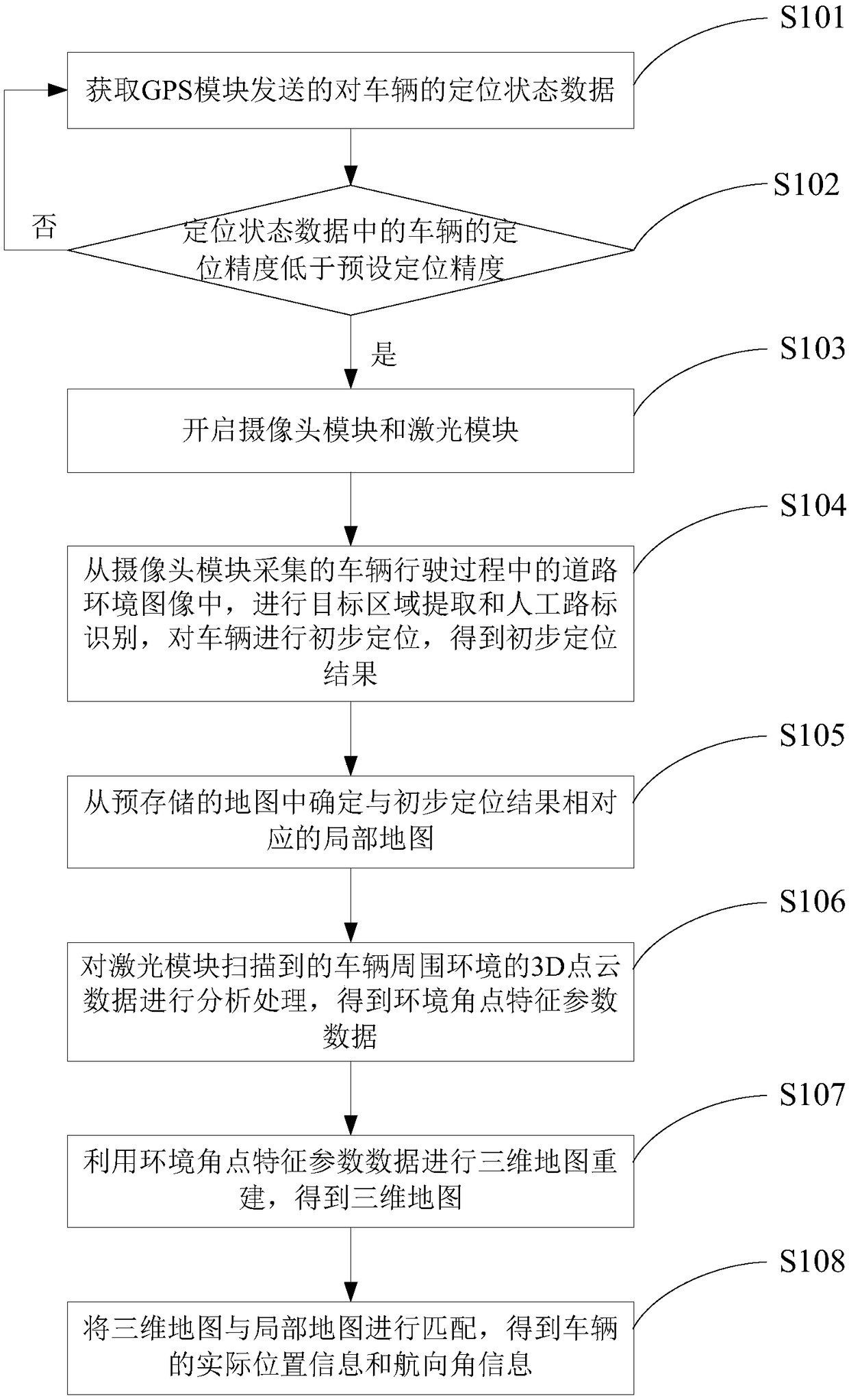
[0049] The following will clearly and completely describe the technical solutions in the embodiments of the present invention with reference to the accompanying drawings in the embodiments of the present invention. Obviously, the described embodiments are only some, not all, embodiments of the present invention. Based on the embodiments of the present invention, all other embodiments obtained by persons of ordinary skill in the art without making creative efforts belong to the protection scope of the present invention.

[0050] The embodiment of the present invention discloses a vehicle positioning method and system to solve the problem of inaccurate positioning and accumulated errors of the GPS module in the blocked traffic environment existing in the traditional solution.

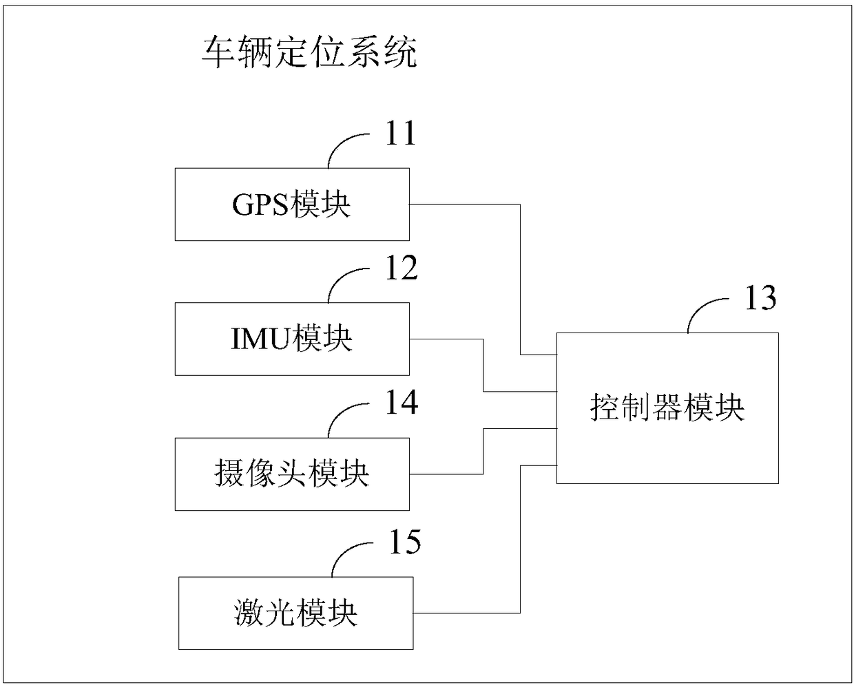
[0051] see figure 1 , a structural schematic diagram of a vehicle positioning system disclosed in an embodiment of the present invention, the system includes: a GPS (Global Positioning System, Global Posi...


PUM


Abstract

The invention discloses a vehicle positioning method and system. The positioning system comprises a GPS module, an IMU module, a camera module, a laser module and a controller module. When a vehicle drives in a shielded traffic environment, the positioning precision of the vehicle by the GPS module is lower than a preset positioning precision, the controller module turns on the camera module and the laser module, and preliminary positioning of the vehicle is performed by employing a road environment image acquired by the camera module; a local map corresponding to a preliminary positioning result is determined from a pre-stored map; three-dimensional map reconstruction is performed by employing 3D point cloud data, scanned by the laser module, of a vehicle surrounding environment; and thereconstructed three-dimensional map and the local map are matched to obtain practical position information and course angle information of the vehicle. According to the method and system, problems ofinaccurate positioning and accumulative errors of the GPS module in the shielded traffic environment are effectively avoided, and the accuracy of vehicle positioning is improved.

Description

technical field [0001] The present invention relates to the technical field of vehicle positioning, and more specifically, to a vehicle positioning method and system. Background technique [0002] Positioning and navigation are two important technologies to realize the automatic driving of intelligent vehicles. In practical applications, vehicle navigation is generally realized through high-precision maps. Usually, high-precision maps store rich environmental information, so they have lane-level guidance capabilities. As the basis of navigation, positioning has become the main research direction to realize the automatic driving of intelligent vehicles. [0003] Currently, GPS (Global Positioning System, Global Positioning System) technology is widely used in the field of vehicle positioning. GPS can provide real-time and all-weather information such as the three-dimensional position, speed and time of the vehicle to realize the positioning of the vehicle. However, when the...

Claims


Application Information

Patent Timeline
IPC IPC(8): G01S19/48G01S19/49G01C21/16
CPCG01C21/165G01S19/48G01S19/49
Inventor 万国强葛彦悟张忠富
Owner BEIJING JINGWEI HIRAIN TECH CO INC
Why Eureka
Try Eureka