Mapping system and method used between BIM model and GIS model

A technology of model and mapping module, applied in the field of geospatial information system, can solve the problems of data loss, incomplete mapping of automatic conversion method, etc., and achieve the effect of avoiding data loss

Inactive Publication Date: 2018-07-24
HKUST SHENZHEN RES INST +1
View PDF4 Cites 16 Cited by
  • Summary
  • Abstract
  • Description
  • Claims
  • Application Information

AI Technical Summary

Problems solved by technology

[0006] Due to the differences in the content and data structure of the two models, the existing automatic conversion methods

Method used


Image

  • Mapping system and method used between BIM model and GIS model
  • Mapping system and method used between BIM model and GIS model
  • Mapping system and method used between BIM model and GIS model

Examples


Embodiment 1

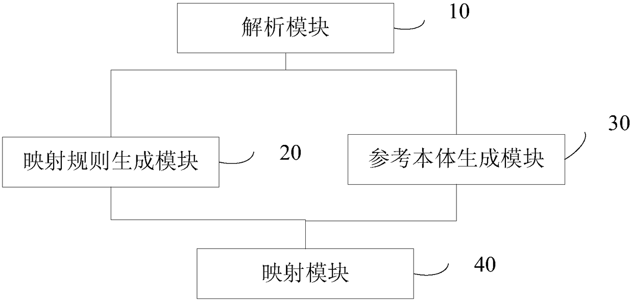
[0053] This embodiment provides a mapping system between a BIM model and a GIS model. see figure 1 , the mapping system used between BIM models and GIS models includes:

[0054] Parsing module 10, for parsing the files of IFC model and CityGML model, generate IFC building component and CityGML building component;

[0055] Specifically, in this embodiment, the parsing module 10 includes an IFC file parser for parsing IFC files and a CityGML file parser for parsing CityGML files built on the JAVA platform. The CityGML file parser is CityGML4j developed by Nagel. CityGML4j can parse CityGML files and generate object trees in the JAVA platform. Therefore it is possible to access the data inside the CityGML file. The IFC file parser uses JSDAI, an application programming interface (API) for reading, writing, and runtime manipulation of object-oriented data defined by an EXPRESS-based data model. By using JSDAI to build the IFC entity library, JAVA can also parse the IFC file i...

Embodiment 2

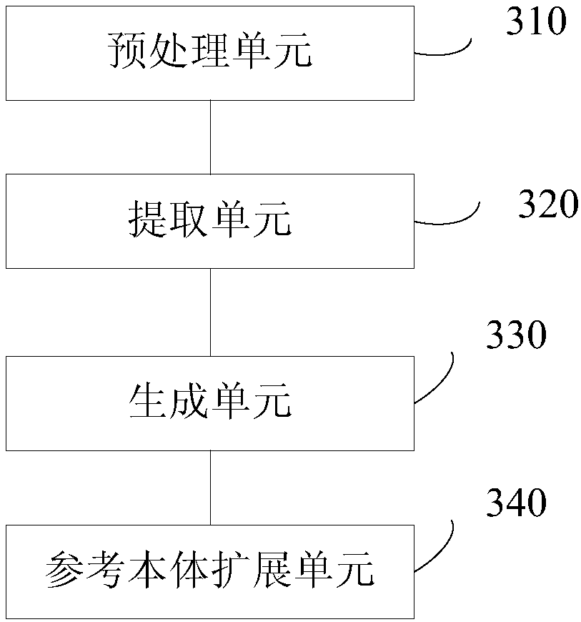
[0084] This embodiment provides a mapping system between a BIM model and a GIS model. see image 3 , the difference from the mapping system shown in Embodiment 1 is that the reference ontology generation module 30 also includes:

[0085] The reference ontology extension unit 340 is configured to extend one or more of the above-mentioned building object entity, the geometric entity, the attribute set entity and the reverse relation entity of the reference ontology.

[0086]When implementing a reference ontology for schema mapping between IFC and CityGML, the concepts stated in the core of the reference ontology can be extended to meet the information requirements of certain building components. Instantiates the core ontology with reference to all building components in the ontology. For example, the concept of "building" in IFC and CityGML corresponds to IfcBuilding and AbstractBuildingType respectively. In the semantic information defined in the attribute set of the referenc...

Embodiment 3

[0089] This embodiment provides a mapping system between a BIM model and a GIS model. see Figure 4 , the difference from the mapping system shown in Embodiment 1 is that the mapping module 40 includes:

[0090] A CityGML extension unit 410, configured to extend the CityGML building component according to the IFC building component when mapping from the IFC model to the CityGML model;

[0091] The CityGML conversion unit 420 is configured to convert between different levels of detail of the CityGML model when mapping from the IFC model to the CityGML model.

[0092] Specifically, the IFC schema contains more information than CityGML, especially in terms of semantic information and inverse relations. Therefore, when mapping from the IFC model to the CityGML model, data loss is inevitable, because some information is not defined in the CityGML schema, which means that an extension to the CityGML schema is required. More information (such as reverse relations and semantic info...


PUM


Abstract

The invention provides a mapping system used between a BIM model and a GIS model. The system comprises an analysis module, a mapping rule generation module, a reference body generation module and a mapping module. The analysis module is used for analyzing files of an IFC model and a CityGML model and generating an IFC building element and a CityGML building element. The mapping rule generation module is used for checking the IFC building element and the CityGML building element and generating a mapping rule on the basis of the model level according to the IFC building element and different assemblies of the CityGML building element. The reference body generation module is used for generating a reference body according to the IFC building element and the CityGML building element. The reference body is composed of a building object entity, a geometry entity, an attribute set entity and a reverse relationship entity. The mapping module is used for mapping the reference body to be a targetmodel by means of the mapping rule. With the mapping system, automatic bidirectional mapping between the BIM model and the GIS model is achieved. Additionally, data loss during a mapping process is reduced.

Description

technical field [0001] The present invention relates to the technical field of geospatial information systems, in particular to a system and method for mapping between BIM models and GIS models. Background technique [0002] The information in the Architecture, Engineering and Construction (AEC) industry is very dense and fragmented, and information sharing among stakeholders in the AEC industry is crucial for collaboration in the construction process. By providing information throughout the building lifecycle, Building Information Modeling (Building Information Modeling, BIM) provides a solution for interoperability in the AEC industry. BIM is the process of creating, storing and managing information related to a building throughout its life cycle. Using BIM, different parties involved in the construction process can work on a common platform, making the cost of information sharing greatly reduced. [0003] A GIS system (Geographic Information System, GIS) is a system tha...

Claims


Application Information

Patent Timeline
IPC IPC(8): G06F17/30
CPCG06F16/288G06F16/29
Inventor 邓逸川郑展鹏
Owner HKUST SHENZHEN RES INST
Why Eureka
Try Eureka