Water and sand prediction method and system for strong alluvial river based on data assimilation

A technology of data assimilation and forecasting method, which is applied in forecasting, data processing applications, electrical digital data processing, etc., and can solve problems such as large errors, inability to assist decision-making, and low precision

Active Publication Date: 2018-07-27
CHINA INST OF WATER RESOURCES & HYDROPOWER RES
View PDF6 Cites 17 Cited by
  • Summary
  • Abstract
  • Description
  • Claims
  • Application Information

AI Technical Summary

Problems solved by technology

These methods ignore the dynamic characteristics and conservation laws of river flow evolution, which lead to large errors and low accuracy when using models to predict real-time water level, flow,

Method used


Image

  • Water and sand prediction method and system for strong alluvial river based on data assimilation
  • Water and sand prediction method and system for strong alluvial river based on data assimilation
  • Water and sand prediction method and system for strong alluvial river based on data assimilation

Examples


Embodiment 1

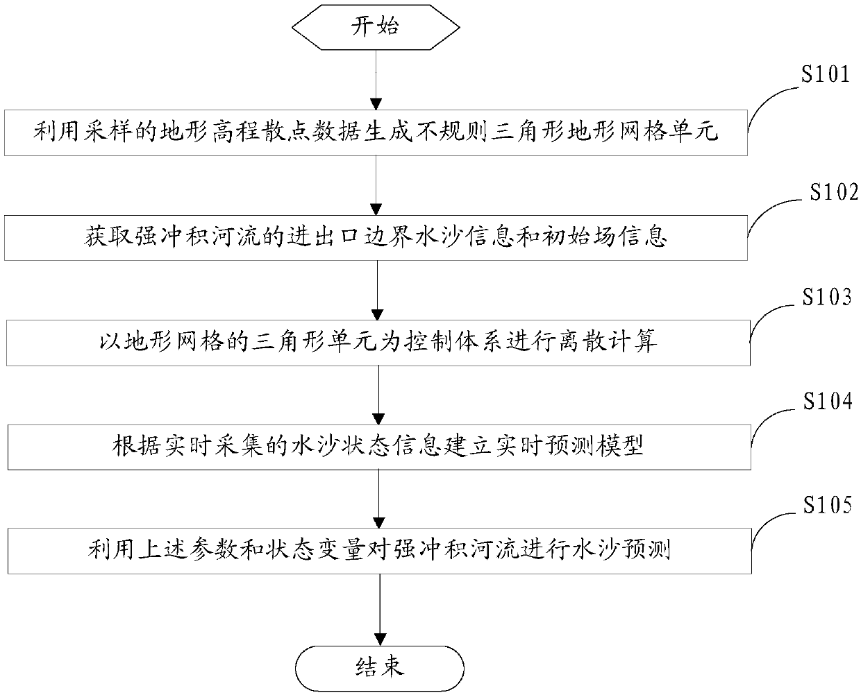
[0044] figure 1 It is a flow chart of the steps of a method for predicting water and sediment of a strong alluvial river based on data assimilation provided by an embodiment of the present invention.

[0045] refer to figure 1As shown, the water and sediment prediction method provided in this embodiment is used to predict the water and sediment conditions of strong alluvial rivers based on the method of data assimilation. The specific water and sediment prediction method includes the following steps:

[0046] S101: Generate irregular triangular terrain grid units by using the terrain elevation scatter data obtained through sampling.

[0047] The terrain grid will include the corresponding triangle unit, which can be used as the discrete control body of the strong alluvial river water-sediment model. The specific generation steps are as follows: first, use the sampled terrain elevation scatter data to generate irregular triangular terrain grid units; then, for irregular trian...

Embodiment 2

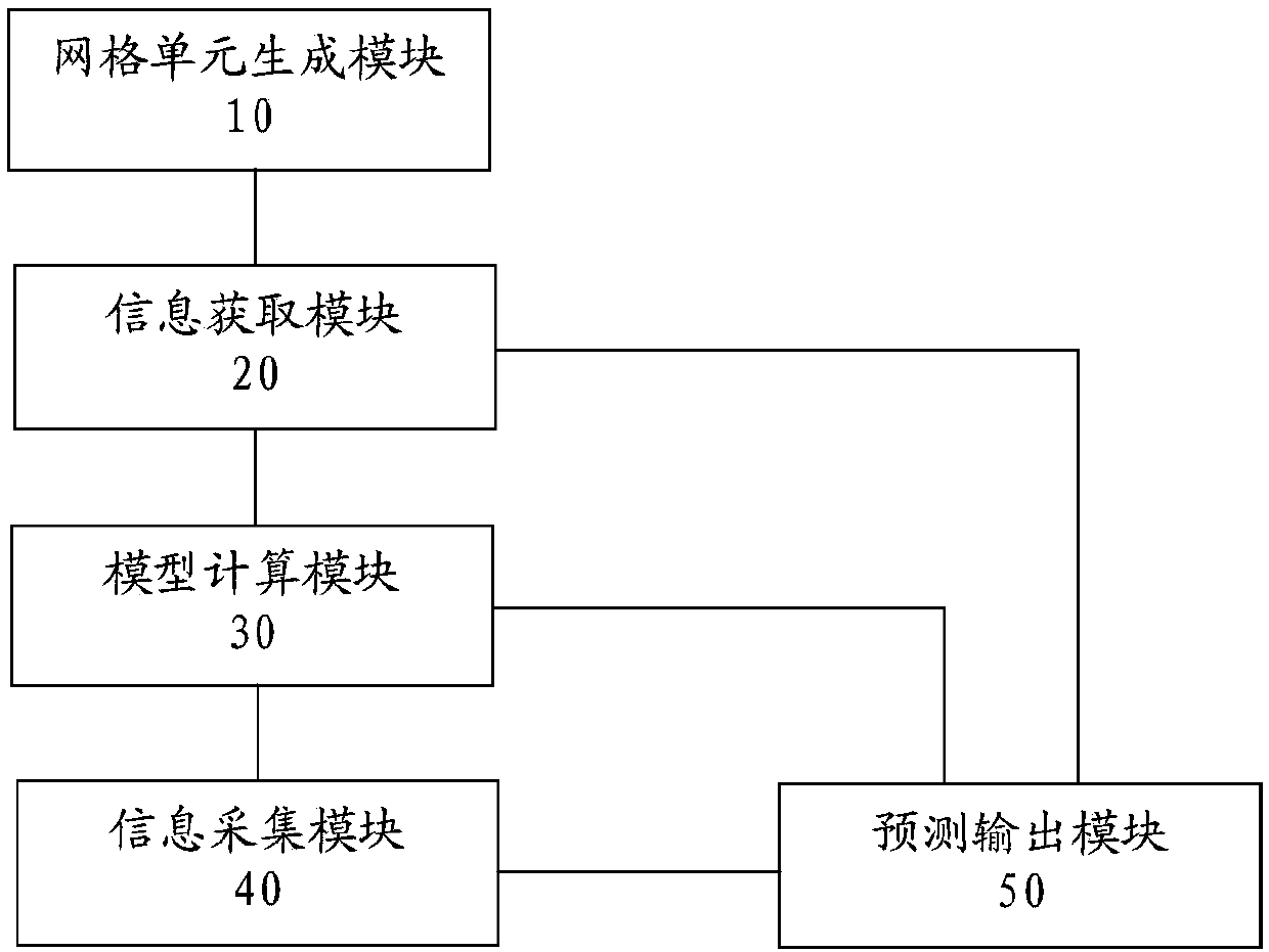
[0143] image 3 A structural block diagram of a water and sediment prediction system for a strong alluvial river based on data assimilation provided by an embodiment of the present invention.

[0144] refer to image 3 As shown, the water and sediment prediction system provided in this embodiment is used to predict the water and sediment conditions of strong alluvial rivers based on the method of data assimilation. The water and sediment prediction system includes a grid unit generation module 10, an information acquisition module 20, and a model calculation module 30 , information collection module 40 and prediction output module 50 .

[0145] The grid unit generation module is used to generate irregular triangular terrain grid units by using the sampled terrain elevation scatter data.

[0146] The terrain grid will include corresponding triangular units, and the triangular units can be used as discrete control volumes of the strong alluvial river water-sediment model. Thi...


PUM


Abstract

The invention provide a water and sand prediction method and system for a strong alluvial river based on data assimilation. The method particularly comprises the steps of using terrain elevation scatter data obtained by sampling to generate an irregular triangular terrain grid unit; obtaining water-sand information and initial field information of strong alluvial river inlet and outlet boundaries;taking triangular elements of terrain grids as control bodies, discretizing a two-dimensional water-sand model of the strong alluvial river, selecting a solution method for calculation, and obtainingcalculated values of the control bodes; acquiring riverway water and sand state information of the strong alluvial river in real time, establishing a real-time prediction model based on the data assimilation according to the water and sand state information, and obtaining assimilation state variables and parameter variables; finally, using a two-dimensional water and sand data assimilation modelto conduct water and sand prediction on the strong alluvial river. Through the above treatment, the real-time status of water and sand of the strong alluvial river can be effectively predicted, so that water and sand regulation can be regulated, and a basis is provided for flood control and disaster alleviation, water environmental protection and water resource management.

Description

technical field [0001] The invention relates to the technical field of water conservancy engineering, in particular to a method and system for predicting water and sediment of strong alluvial rivers based on data assimilation. Background technique [0002] As the global climate changes, the underlying surface of the watershed will change accordingly, and with the construction of dams and other human activities, the natural water and sediment situation and the boundary conditions of water and sediment transport will be changed, which may lead to collapse. The occurrence of extreme events such as dams will further lead to active water-sediment movement and rapid riverbed deformation, which will bring difficulties to the scientific understanding of the mechanism of water-sediment interaction in the alluvial river process and bring more difficulties to predict changes in water-sediment movement. big challenge. [0003] The parameters of the water-sediment model are affected by ...

Claims


Application Information

Patent Timeline
IPC IPC(8): G06F17/50G06Q10/04
CPCG06Q10/04G06F30/23Y02A10/40
Inventor 冶运涛曹引尚毅梓梁犁丽蒋云钟龚家国仇亚琴杜龙江王浩
Owner CHINA INST OF WATER RESOURCES & HYDROPOWER RES
Why Eureka
Try Eureka