
Standard plane laser ranging total station instrument height measuring system and using method

A laser ranging and measurement system technology, applied in the field of measurement, can solve problems such as laser ranging error, poor reflected light intensity and quality, and chaotic direction of laser reflected light, so as to achieve simple leveling, avoid operation errors, and ensure laser measurement The effect of distance accuracy

Active Publication Date: 2018-08-03
HUNAN UNIV OF SCI & TECH
View PDF9 Cites 0 Cited by
  • Summary
  • Abstract
  • Description
  • Claims
  • Application Information

AI Technical Summary

Problems solved by technology

This is because, 1. When the laser is centered, the laser center is injected into the groove, and the measured distance may go deep into the groove, not the distance to the top surface of the measurement mark; 2. The inside of the groove and its surroundings are uneven If it is uneven, the direction of the laser reflected light will be confused, and the intensity and quality of the reflected light received by the laser receiving end will be very poor, which will bring great errors to the laser ranging
[0009] The measurement accuracy of the above measurement methods is millimeter level, which is not suitable for occasions that require high parameters of precise instruments

Method used


Image

  • Standard plane laser ranging total station instrument height measuring system and using method
  • Standard plane laser ranging total station instrument height measuring system and using method
  • Standard plane laser ranging total station instrument height measuring system and using method

Examples


Embodiment 1

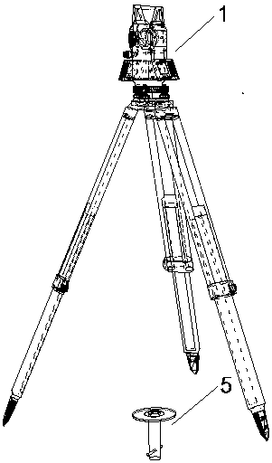
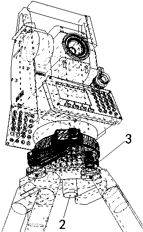
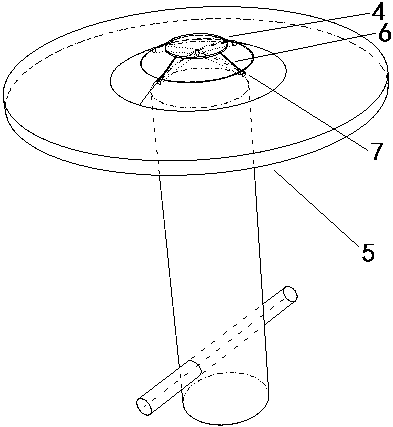
[0031] Such as Figure 1-3 As shown, the instrument height measurement system of the laser ranging total station on the standard plane includes the total station and the laser displacement sensor. The laser displacement sensor is installed vertically downward at the center of the base of the total station, and its feature is that it also includes a laser reflection cap , the reflective cap is in the shape of a table, and there are four marked vertical lines symmetrically distributed along its central axis on the side. Covered on the spherical protrusion of the measurement mark, the four vertical lines of the mark are aligned with the edges of the cross groove-shaped centering mark on the spherical protrusion of the measurement mark.

[0032] The laser of the laser displacement sensor is red visible light, and the laser displacement sensor also serves as a laser plummet, which is connected with the total station host through a data line.

[0033] Such as Figure 4 As shown, t...

Embodiment 2

[0039] Such as Figure 1-3 As shown, the instrument height measurement system of the laser ranging total station on the standard plane includes a total station and a laser displacement sensor. The laser displacement sensor is installed vertically downward at the center of the base of the total station, and is characterized in that it also includes a laser reflection cap , the reflective cap is in the shape of a table, and there are four marked vertical lines symmetrically distributed along its central axis on the side. Covered on the spherical protrusion of the measurement mark, the four vertical lines of the mark are aligned with the edges of the cross-groove centering mark on the spherical protrusion of the measurement mark.

[0040] The laser of the laser displacement sensor is red visible light, and the laser displacement sensor also serves as a laser plummet, which is connected with the total station host through a data line.

[0041] Such as Figure 5 As shown, the mat...


PUM


Abstract

The invention aims to achieve the technical purpose of improving the laser measurement precision of the total station instrument height. A standard plane laser ranging total station instrument heightmeasuring system comprises a total station and a laser displacement sensor, the laser displacement sensor is vertically installed in the center of a total station base downwards. The standard plane laser ranging total station instrument height measuring system is characterized by further comprising a laser reflection cap which is in a circular truncated cone shape, four vertical marker lines whichare symmetrically distributed along the central axis of the reflection cap are arranged on the side face, the upper surface of the reflection cap is flat, and the lower surface of the reflection capis spherical, wherein the spherical curvature is equal to that of the upper surface on a measurement marker. When the instrument height is measured through laser, a spherical bulge of the measurementmarker is covered with the reflection cap, and the four vertical marker lines are aligned to the edges of an alignment marker in a crossed groove shape on the spherical bulge of the measurement marker. The system has the advantages that the groove in the alignment marker on the survey marker is covered with the laser reflection cap, the errors which are brought by the groove to laser ranging are eliminated; the laser reflection cap is easily leveled, and the upper surface of the reflection cap is flat, so that the laser ranging precision is ensured.

Description

technical field [0001] The invention relates to the technical field of measurement, in particular to the measurement of the instrument height of a total station. Background technique [0002] The instrument height is the vertical distance from the ground measurement control point where the total station is erected to the center point of the instrument dial. The high accuracy of the total station instrument directly determines the coordinate elevation to be measured and the accuracy of triangular elevation measurement, which has a great impact on the entire measurement accuracy. [0003] (1) Steel tape measurement method [0004] The most traditional method of measuring instrument height. The height of the instrument is the vertical distance from the measurement control point to the center of the instrument dial. Direct measurement is not a plane relationship, so there are errors. In addition, the measurement accuracy of the steel tape is not high. [0005] (2) Suspension ...

Claims


Application Information

Patent Timeline
Patent Type & Authority Applications(China)
IPC IPC(8): G01S17/08
CPCG01S17/08
Inventor 廖孟光李羲李朝奎卜璞刘正佳
Owner HUNAN UNIV OF SCI & TECH
Learn More