Coastal wetland land cover information extraction method based on integrated multi-source remote sensing data

A technology of land cover and remote sensing data, applied in image data processing, instrument, character and pattern recognition, etc.

Inactive Publication Date: 2018-08-10
INST OF REMOTE SENSING & DIGITAL EARTH CHINESE ACADEMY OF SCI
View PDF8 Cites 7 Cited by
  • Summary
  • Abstract
  • Description
  • Claims
  • Application Information

AI Technical Summary

Problems solved by technology

[0004] The purpose of the present invention is to provide a method for extracting coastal wetland land cover information that integrates optical and SAR data, to overcome the shortcomings of the existing methods

Method used


Image

  • Coastal wetland land cover information extraction method based on integrated multi-source remote sensing data
  • Coastal wetland land cover information extraction method based on integrated multi-source remote sensing data
  • Coastal wetland land cover information extraction method based on integrated multi-source remote sensing data

Examples


Embodiment Construction

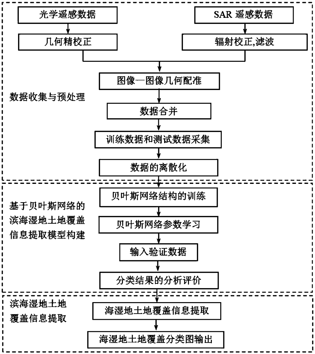
[0016] In order to make the object, technical solution and advantages of the present invention clearer, the present invention will be further described in detail below in conjunction with the accompanying drawings. It should be understood that the specific embodiments described here are only used to explain the present invention, and are not intended to limit the present invention.

[0017] Such as figure 1 The present invention discloses a method for extracting coastal wetland land cover information from integrated optical and SAR images, comprising the following steps:

[0018] The first step, data collection and preprocessing in the study area;

[0019] The second step is to build a coastal wetland land cover information extraction model based on Bayesian network;

[0020] The third step is to extract coastal wetland land cover information.

[0021] The specific steps are described in detail below:

[0022] Data collection and preprocessing in the study area. Collect c...


PUM


Abstract

The invention discloses a coastal wetland land cover information extraction method based on integrated multi-source remote sensing data. The method mainly comprises three steps: 1) data collection andpretreatment: to begin with, collecting cloudless optical and SAR remote sensing data in a research area and carrying out corresponding pretreatment, then, combining the two into an integrated data set, and collecting training data and test data and carrying out discretization processing; 2) constructing a coastal wetland land cover information extraction Bayesian network model through a conditional independence test method; and 3) carrying out land cover classification on the multi-dimension data set by utilizing the established Bayesian network model, and realizing automatic extraction of coastal wetland land cover information. The method can realize automatic extraction of land cover information well through integrated utilization of respective advantages of optical and SAR images, andhas high operability and practicality.

Description

technical field [0001] The invention relates to a method for extracting coastal wetland land cover information by integrating multi-source remote sensing data, which is suitable for the field of land cover information extraction and monitoring. Background technique [0002] Coastal wetlands are transition zones between terrestrial ecosystems and marine ecosystems, and are also areas where the ecological environment is relatively fragile, with significant succession and diversity. The research on the extraction method of coastal wetland land cover information can provide good information support for the ecological environment evaluation and ecological protection of the wetland area. With the rapid development of remote sensing technology, the types of remote sensing data are becoming more and more abundant, and it has become an important data source for surface land cover information extraction. All kinds of remote sensing data have also been well applied in the extraction o...

Claims


Application Information

Patent Timeline
Patent Type & Authority Applications(China)
IPC IPC(8): G06K9/00G06K9/62G06T7/30
CPCG06T7/30G06T2207/30181G06T2207/20081G06T2207/10044G06T2207/10032G06V20/13G06F18/241
Inventor 戴芹杨进刘士彬刘建波马彩虹
Owner INST OF REMOTE SENSING & DIGITAL EARTH CHINESE ACADEMY OF SCI
Why Eureka
Try Eureka