Supercharge Your Innovation With Domain-Expert AI Agents!

Fast resolution method of ambiguity between multi-constellation reference stations and its application

An ambiguity and multi-constellation technology, applied in the field of global navigation satellite system satellite positioning, can solve problems such as difficult fixation, large atmospheric errors, and affecting Ratio values, so as to increase availability, Ratio values, and success rates, and initialize time shortened effect

Active Publication Date: 2022-01-11
SOUTHEAST UNIV +1
View PDF0 Cites 0 Cited by
  • Summary
  • Abstract
  • Description
  • Claims
  • Application Information

AI Technical Summary

Problems solved by technology

Due to the large atmospheric error of the newly rising satellite (especially the tropospheric delay), it is very difficult to fix it when it is first added to the filter equation, and it will affect the Ratio value of the overall ambiguity solution

Method used


Image

  • Fast resolution method of ambiguity between multi-constellation reference stations and its application
  • Fast resolution method of ambiguity between multi-constellation reference stations and its application
  • Fast resolution method of ambiguity between multi-constellation reference stations and its application

Examples


Embodiment Construction

[0040] The present invention will be further described below in conjunction with the accompanying drawings.

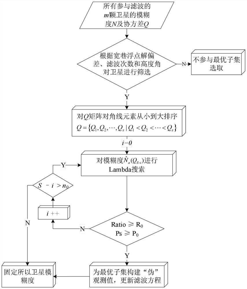
[0041] A fast ambiguity resolution method between multi-constellation reference stations based on ambiguity tight constraints. Firstly, the satellites that are easy to fix are determined according to the satellite cut-off altitude angle, ambiguity floating-point solution deviation and continuous filtering times; then, using the partial ambiguity strategy, The size of the ambiguity variance is used as the screening standard, and the ambiguity fixed success rate and Ratio are the thresholds to select the optimal subset of ambiguity; finally, the method of constructing a "pseudo" observation equation is used to apply strong ambiguity to the optimal subset. Constrain to a fixed solution, update the filter equations, and fix all satellite ambiguities.

[0042] Further, a fast ambiguity resolution method between multi-constellation reference stations based on tight ambiguity c...


PUM


Abstract

The invention discloses a fast ambiguity resolution method among multi-constellation reference stations based on ambiguity tight constraints and its application. Firstly, satellites that are easy to fix are determined according to the satellite cut-off altitude angle, ambiguity floating-point solution deviation and continuous filtering times; Then use the partial ambiguity fixation strategy for satellites that are easy to fix, use the size of the ambiguity variance as the screening criterion, and set the success rate of ambiguity fixation and Ratio as thresholds to select the optimal subset of ambiguity; finally, construct a "pseudo" observation equation In this way, the ambiguities in the optimal subset are tightly constrained to the fixed solution, the filtering equations are updated, and all satellite ambiguities are fixed. Using the method proposed by the present invention can significantly improve the prior success rate and Ratio value of fixed ambiguity, shorten the initialization time between reference stations, accelerate the convergence speed of newly rising satellites, and provide more available information for network RTK users. satellite.

Description

technical field [0001] The invention relates to a global navigation satellite system (GNSS) satellite positioning method, in particular to fast and accurate resolution of ambiguities between RTK (Real-Time Kinematic) reference stations in a multi-constellation network. Background technique [0002] With the continuous development of unmanned driving and digital cities, all walks of life have put forward higher requirements for the continuity, real-time and positioning accuracy of precise positioning. Combined with the established GPS, GLONASS and the rapidly improving BDS and Galileo, the number of satellites in orbit of the global satellite navigation system has also increased significantly, laying the foundation for high-precision positioning. At the same time, network RTK technology has attracted much attention in real-time high-precision positioning applications because it can obtain uniform and high-precision positioning results in real time in a large spatial range. Am...

Claims


Application Information

Patent Timeline
Patent Type & Authority Patents(China)
IPC IPC(8): G01S19/44G01S19/28
CPCG01S19/28G01S19/44
Inventor 潘树国张瑞成闫志跃高成发王彦恒张建刘国良
Owner SOUTHEAST UNIV
Features
  • R&D
  • Intellectual Property
  • Life Sciences
  • Materials
  • Tech Scout
  • Unparalleled Data Quality
  • Higher Quality Content
  • 60% Fewer Hallucinations
Learn More