Geological map dynamic synthesis method and system considering proximity relationship

An integrated method and geological map technology, applied in the field of dynamic integrated method and system of geological maps considering the proximity relationship, can solve the problems of heavy update workload, long geological map production cycle and update cycle, slow geological map update, etc. To achieve the effect of accurate experimental results

Active Publication Date: 2018-09-04
WUHAN UNIV OF SCI & TECH
View PDF4 Cites 2 Cited by
  • Summary
  • Abstract
  • Description
  • Claims
  • Application Information

AI Technical Summary

Problems solved by technology

[0008] (1) At present, the main problems faced by geological maps in terms of synthesis are: the diversity of geological data sources makes data processing difficult; the spatiotemporal attributes of geological data make the update process of geological maps slow; the value of geological data application sites
[0009] (2) Th

Method used


Image

  • Geological map dynamic synthesis method and system considering proximity relationship
  • Geological map dynamic synthesis method and system considering proximity relationship
  • Geological map dynamic synthesis method and system considering proximity relationship

Examples


Embodiment Construction

[0093] In order to make the object, technical solution and advantages of the present invention clearer, the present invention will be further described in detail below in conjunction with the examples. It should be understood that the specific embodiments described here are only used to explain the present invention, not to limit the present invention.

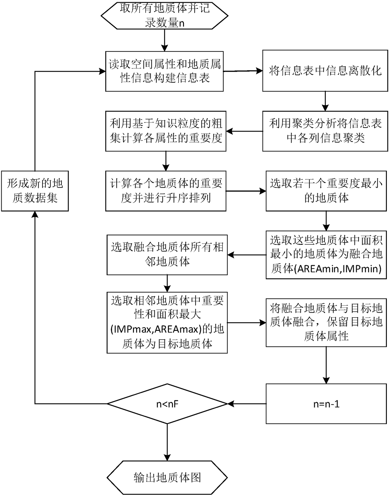
[0094] The comprehensive process in the production of traditional geological maps relies heavily on manual mapping experience and level, resulting in long geological map production and update cycles, heavy update workload, and poor spatial information preservation accuracy.

[0095] The embodiment of the present invention proposes a geological map synthesis method considering the proximity of geological bodies. This method introduces the classification function of cluster analysis and the weight calculation function of rough set, including the calculation process as follows:

[0096] Step 1, according to the geological map th...


PUM


Abstract

The present invention belongs to the technical field of geological detection data processing, discloses a geological map dynamic synthesis method and system considering a proximity relationship, and proposes a dynamic geological map synthesis method for the situation of over-reliance on labor existing in the current geological map synthesis. The method can be used to comprehensively process the Jiaguan town map. By using the dynamic geological map synthesis method disclosed by the present invention, the process of over-reliance on manual participation in the traditional geological map synthesis process is overcome, and the method is more efficient; the weight of the geological body spatial information and attribute information is analyzed, and the experimental result is more accurate; clustering analysis and rough set calculation are used, and better effects are achieved; and the method can be promoted to other cartographic fields such as mineral resource maps, planning and utilizationmaps and other thematic maps.

Description

technical field [0001] The invention belongs to the technical field of geological detection data processing, and in particular relates to a method and system for dynamic synthesis of geological maps taking into account the proximity relationship. Background technique [0002] At present, the existing technologies commonly used in the industry are as follows: [0003] The development of economy and society needs strong geological data as support. In the era of big data, higher requirements are put forward for the ability of modern geological survey, management, processing and analysis. Geological data currently not only exist for the purpose of recording geological phenomena, but also It must meet higher requirements such as information resource mining and information services. At present, most of the small-scale geological maps used in my country are still hand-made by cartographers. With the continuous improvement of the application level of geological maps, the update t...

Claims


Application Information

Patent Timeline
IPC IPC(8): G06F17/30G06T11/20
CPCG06T11/206
Inventor 李雯静石勇龙杨晨曦胡丹刘怡李思怡
Owner WUHAN UNIV OF SCI & TECH
Why Eureka
Try Eureka