Robot for geological mapping

A robot and geological technology, applied in the direction of surveying instruments, surveying and navigation, instruments, etc., can solve problems affecting measurement results, geological influences, complex operations, etc.

Active Publication Date: 2018-09-14
南京立方测绘科技有限公司
View PDF4 Cites 2 Cited by
  • Summary
  • Abstract
  • Description
  • Claims
  • Application Information

AI Technical Summary

Problems solved by technology

[0002] In the process of geological surveying and mapping, it is necessary to carry out borehole measurement frequently. The traditional way is to drill through the equipment first, and then measure. In order to consider designing a robot for geological surveying and mapping

Method used


Image

  • Robot for geological mapping
  • Robot for geological mapping

Examples


Embodiment Construction

[0012] Below in conjunction with accompanying drawing and specific embodiment the present invention is described in further detail:

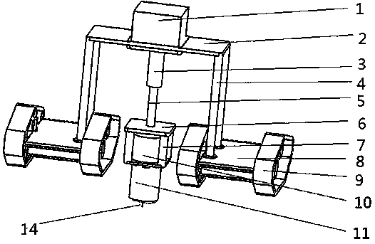
[0013] The invention provides a robot for geological surveying and mapping, which can automatically drill holes. There is a measuring instrument at the end of the drill bit. After drilling, just extend the measuring end directly for surveying and mapping, which can simplify the surveying and mapping process in corresponding places and improve the overall efficiency.

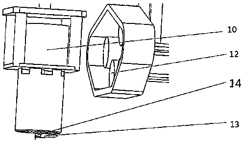
[0014] As an embodiment of the structure of the present invention, the present invention provides a robot for geological surveying and mapping, including a hydraulic oil tank 1, a support plate 2, a hydraulic cylinder 3, a support 4, a hydraulic rod 5, a movable plate 6, a mounting frame 7, and a mobile seat robot Main body 8, hollow shaft rotating motor 10, digging mold 11, screw excavation blade 13 and activity measuring instrument 14, described mobile seat robot main body 8 has a...


PUM


Abstract

The invention provides a robot for geological mapping. The robot provided by the invention comprises a pair of movable seat robot main bodies; each movable seat robot main body is connected with a supporting plate through brackets; a hydraulic oil tank is arranged on the supporting plate; the lower side of the supporting plate is connected with a movable plate through a hydraulic rod of a hydraulic cylinder; a mounting frame is mounted below the movable plate; a hollow shaft rotary motor is mounted in the mounting frame; a hole digging mold is arranged at the bottom of the mounting frame; a rotary shaft of the hollow shaft rotary motor is arranged in the hole digging mold; a spiral digging blade is arranged at the end part of the rotary shaft of the hollow shaft rotary motor; an inner retractable air cylinder is arranged in the hollow shaft rotary motor; a movable measuring instrument is arranged at the end part of a retractable rod of the inner retractable air cylinder. The robot provided by the invention can be used for automatically drilling a hole; the measuring instrument is arranged at the end part of a drilling bit; a measuring end can directly stretch out to carrying out mapping after hole drilling is finished, so that the whole efficiency of a corresponding geological mapping flow can be simplified.

Description

technical field [0001] The invention relates to the field of geological surveying and mapping robots, in particular to a geological surveying and mapping robot. Background technique [0002] In the process of geological surveying and mapping, it is necessary to carry out borehole measurement frequently. The traditional way is to drill through the equipment first, and then measure. In order to consider designing a robot for geological surveying and mapping. Contents of the invention [0003] In order to solve the above problems, the present invention provides a robot for geological surveying and mapping, which can automatically drill holes. There is a measuring instrument at the end of the drill bit. After drilling, just extend the measuring end directly for surveying and mapping, which can simplify the surveying and mapping of corresponding places. The process improves the overall efficiency. To achieve this goal, the present invention provides a robot for geological surv...

Claims


Application Information

Patent Timeline
Patent Type & Authority Applications(China)
IPC IPC(8): G01C15/00E21B47/00
CPCE21B47/00G01C15/00
Inventor 薛恒安王俊冯程伟侯光明张宏洋
Owner 南京立方测绘科技有限公司
Why Eureka
Try Eureka