Camera remote trigger system and method for geographical plotting

A camera and remote technology, applied in the field of camera remote trigger system for geographic surveying and mapping, can solve the problems of inability to make mistakes, complicated, and high requirements for surveying and mapping personnel, and achieve the effect of saving cost, small size and improving operation efficiency.

Inactive Publication Date: 2016-06-15
NORTHWESTERN POLYTECHNICAL UNIV
View PDF3 Cites 4 Cited by
  • Summary
  • Abstract
  • Description
  • Claims
  • Application Information

AI Technical Summary

Problems solved by technology

This process is very complicated and has high requirements for surveyors and mappers. Every link must not make mistakes. After the final drawing is completed, it is necessary to go through on-site inspections to check whether there are any wrong drawings or omissions during the operation process.

Method used


Image

  • Camera remote trigger system and method for geographical plotting
  • Camera remote trigger system and method for geographical plotting
  • Camera remote trigger system and method for geographical plotting

Examples


Embodiment Construction

[0046]The present invention will be further described below in conjunction with the embodiments shown in the accompanying drawings.

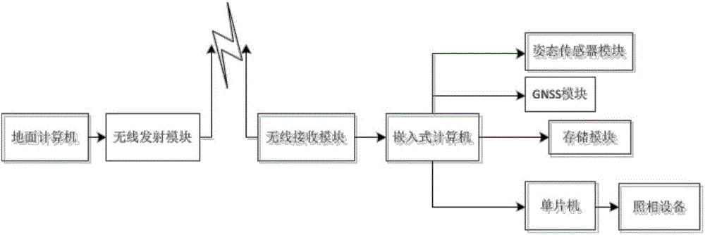
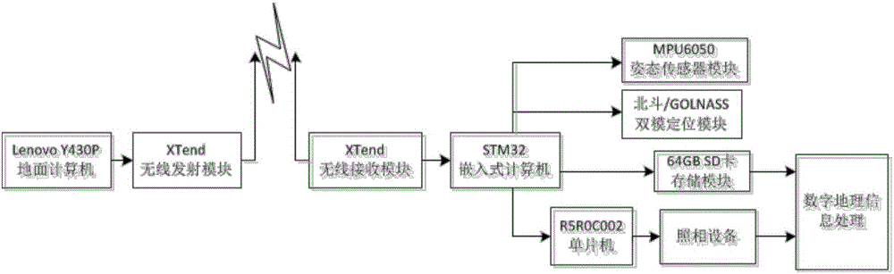
[0047] The basic principle of the present invention is: the trigger command generated by the ground computer is transmitted to the embedded computer through the wireless transmission module through the data link, and the real-time information sent by the GNSS module and the attitude sensor module is sent by the embedded computer while recognizing the trigger command. The data is stored in the storage module, and the trigger high-level signal is sent to the single-chip microcomputer through the I / O port through the CAN bus, and the single-chip microcomputer triggers the shutter action of the camera device through the MicroUSBv2.0 interface, and the camera device will trigger Order time data to be written into digital images, match digital images with real-time information data through time information, and develop digital geographic information pr...


PUM


Abstract

The invention provides a camera remote trigger system and method for geographic surveying and mapping, belonging to the technical field of geographic surveying and mapping equipment. The system includes an embedded computer, a GNSS module, an attitude sensor module, a ground computer, a wireless transmitting module, a wireless receiving module, Memory modules, microcontrollers and camera equipment. The embedded computer is connected with the wireless receiving module, receives the trigger command sent by the ground station through the wireless transmitting module, and the embedded computer immediately stores the real-time information data sent by the GNSS module and the attitude sensor module into the storage module, and triggers The high level is sent to the microcontroller, and the trigger signal triggers the shutter action of the camera device through the Micro USB v2.0 interface. The invention can match the aerial photographing geographical information of the unmanned aerial vehicle in real time, and can complete the collection of digital geographical information of the survey area without large-scale auxiliary surveying and mapping equipment on the ground.

Description

technical field [0001] The invention relates to the technical field of geographic surveying and mapping equipment, in particular to a camera remote trigger system and method for geographic surveying and mapping. Background technique [0002] With the development of social economy and the increasing frequency of construction activities, the speed of updating topographic maps is also increasing. The traditional digital mapping technology method has low efficiency and high cost, and is also affected by objective conditions, such as weather, terrain, etc. factors. [0003] Traditional digital surveying and mapping technology requires a large number of surveying and mapping personnel, and the labor intensity is high. Step by step from high-level control survey to map root control, and then use total station for data collection, and finally use computer to use professional Mapping software for internal mapping. This process is very complicated and has high requirements for surve...

Claims


Application Information

Patent Timeline
Patent Type & Authority Applications(China)
IPC IPC(8): G01C11/02
CPCG01C11/02
Inventor 高逦王逸帆孙鹏
Owner NORTHWESTERN POLYTECHNICAL UNIV
Why Eureka
Try Eureka