Intelligent surveying and mapping system and method

An intelligent and intelligent terminal technology, applied in the field of surveying and mapping systems, can solve problems such as recording errors, cumbersome working modes, and affecting the work efficiency of surveying and mapping personnel, and achieve the effect of improving efficiency and simplifying the surveying and mapping process

Inactive Publication Date: 2015-07-08
广州科创云科技股份有限公司
View PDF6 Cites 12 Cited by
  • Summary
  • Abstract
  • Description
  • Claims
  • Application Information

AI Technical Summary

Problems solved by technology

[0003] This working mode is relatively cumbersome. Surveyors first need to measure and record data, then draw sketches, and finally use CAD software to draw the final plan, which greatly affects the work efficiency of surveyors.
In addition, due to the manual operation, it is easy to record errors for a large amount of complex data

Method used


Image

  • Intelligent surveying and mapping system and method
  • Intelligent surveying and mapping system and method

Examples


Embodiment Construction

[0024] The present invention will be further described in detail below in conjunction with the accompanying drawings and specific embodiments.

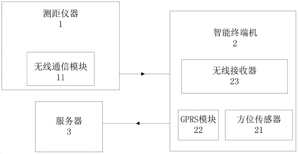
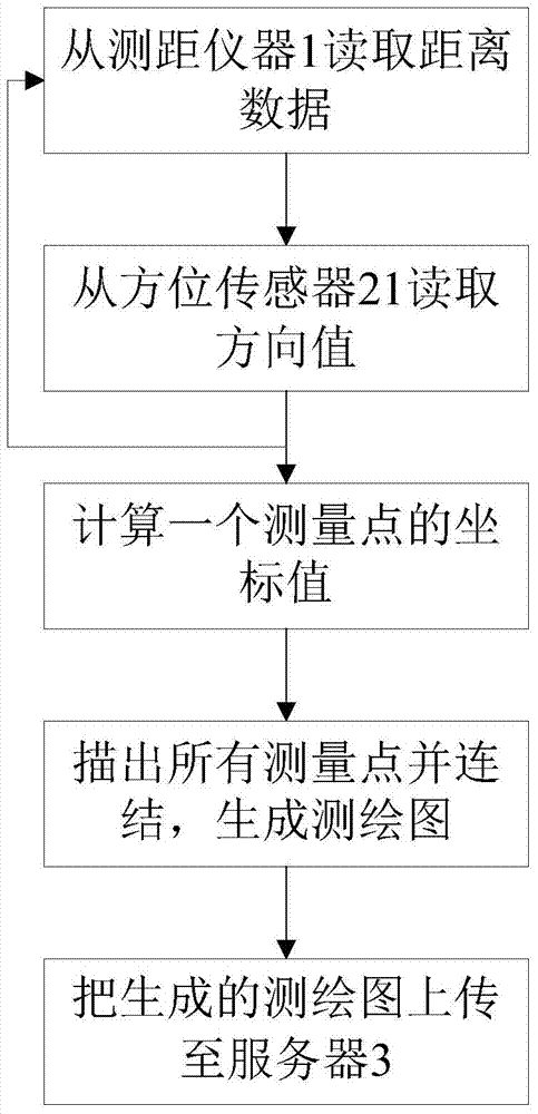
[0025] Such as figure 1 As shown, the intelligent surveying and mapping system of the present invention includes a distance-measuring instrument 1 and an intelligent terminal 2. Preferably, the distance-measuring instrument 1 in this embodiment uses a laser rangefinder, and the intelligent terminal 2 can use a smart phone or a tablet Computers and other equipment can be realized, and a special terminal equipment can also be made separately. The distance measuring instrument 1 is also provided with a wireless communication module 11, and the intelligent terminal machine 2 is provided with a wireless receiving module 23, and the wireless communication module 11 is used to transmit the distance data measured by the distance measuring instrument 1 to the wireless reception of the intelligent terminal machine 2. Module 23; the intelligent...


PUM


Abstract

The invention provides an intelligent surveying and mapping system including a distance measuring instrument and an intelligent terminal; the distance measuring instrument is also provided with a wireless communication module, and the intelligent terminal is provided with a wireless receiving module; the wireless communication module is used for transmitting distance data measured by the distance measuring instrument to the wireless receiving module of the intelligent terminal; the intelligent terminal is provided with a direction sensor for measuring a direction value and is used for corresponding a set of distance data and direction value to one measurement point and generating a surveyed and mapped graph according to all the measurement points. The invention also discloses corresponding intelligent surveying and mapping. According to the intelligent surveying and mapping system and method, manual drawing of a surveyor is not required, the surveyed and mapped planar graph can be drawn, the surveying and mapping process is simplified, and the efficiency is improved.

Description

technical field [0001] The invention relates to a surveying and mapping system and method. Background technique [0002] At present, when the surveyors and mappers of the Housing Management Bureau survey houses, warehouses, factories, garages and other buildings, their surveying and mapping workflow is as follows: the surveyor surveys the data with a distance measuring instrument, and the other surveyor records the data with a pen and draws a rough sketch. After returning to the office, the surveyor will use CAD software on the computer to make the final drawing according to the sketch. [0003] This working mode is relatively cumbersome. Surveyors first need to measure and record data, then draw sketches, and finally use CAD software to draw the final plan, which greatly affects the work efficiency of surveyors. In addition, due to the manual operation, it is easy to record errors for a large amount of complex data. Contents of the invention [0004] In view of the abov...

Claims


Application Information

Patent Timeline
Patent Type & Authority Applications(China)
IPC IPC(8): G01C7/00G08C17/02
CPCG01C15/00G08C17/02
Inventor 陆锐锋
Owner 广州科创云科技股份有限公司
Why Eureka
Try Eureka