Geographic information based cartographic data three-dimensional display system
A mapping data and geographic information technology, applied in the field of geographic information, can solve the problems of insufficient multi-source data fusion, insufficient display and use of dwg data, and insufficient three-dimensional model analysis functions.
- Summary
- Abstract
- Description
- Claims
- Application Information
AI Technical Summary
Problems solved by technology
Method used
Image
Examples
Embodiment 1
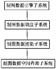
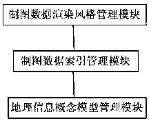
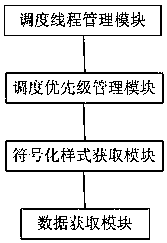
[0076] figure 1 A schematic structural diagram of the three-dimensional display system for cartographic data based on geographic information provided in this embodiment, as shown in figure 1 As shown, a three-dimensional display system for cartographic data based on geographic information includes: a cartographic data engine subsystem, a cartographic data scheduling subsystem, a cartographic data rendering subsystem, and a cartographic data space query subsystem; the cartographic data engine subsystem: Store, schedule, and read entity display styles and rendering field names of cartographic data, create database indexes, spatial indexes, and pagination indexes for cartographic feature classes, store and schedule created indexes, and reference spaces for cartographic data Reference is made to storage and configuration, and geographic information management is performed on massive cartographic data by feature class and data set; the cartographic data scheduling subsystem: respon...
PUM
 Abstract
Description
Claims
Application Information
 - R&D
- Intellectual Property
- Life Sciences
- Materials
- Tech Scout
- Unparalleled Data Quality
- Higher Quality Content
- 60% Fewer Hallucinations
Browse by: Latest US Patents, China's latest patents, Technical Efficacy Thesaurus, Application Domain, Technology Topic, Popular Technical Reports.
© 2025 PatSnap. All rights reserved.Legal|Privacy policy|Modern Slavery Act Transparency Statement|Sitemap|About US| Contact US: help@patsnap.com


