
A 3D Display System of Cartographic Data Based on Geographical Information

A mapping data and geographic information technology, applied in the field of geographic information, can solve the problems of insufficient display and use of dwg data, not being able to be reflected intuitively, and insufficient multi-source data fusion, so as to achieve the effect of improving service capabilities.

Active Publication Date: 2021-08-17
星际空间(天津)科技发展有限公司
View PDF11 Cites 0 Cited by
  • Summary
  • Abstract
  • Description
  • Claims
  • Application Information

AI Technical Summary

Problems solved by technology

[0004] The three-dimensional representation can give users more intuitive spatial elevation information, while the traditional two-dimensional representation reflects the plane position of spatial objects, and its elevation information only exists as an attribute value and cannot be reflected intuitively
[0007] However, there are some key technical problems in the current 3D GIS system, such as the 3D model focuses on browsing but lacks analysis functions, the fusion of multi-source data is not perfect, the display and use of dwg data is insufficient, and the organization and management of massive data, etc.
At present, there is no software that can quickly display massive dwg data as it is while displaying massive 3D models, seamless integration of multi-source dwg data, storage and GIS management of massive dwg data, spatial analysis and application of massive dwg data, etc. , realize the effective mining of dwg data information, improve the use efficiency and economic value of existing dwg data

Method used


Image

  • A 3D Display System of Cartographic Data Based on Geographical Information
  • A 3D Display System of Cartographic Data Based on Geographical Information
  • A 3D Display System of Cartographic Data Based on Geographical Information

Examples


Embodiment 1

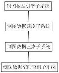
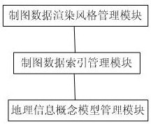
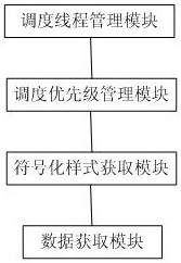
[0076] figure 1 A schematic structural diagram of the three-dimensional display system for cartographic data based on geographic information provided in this embodiment, as shown infigure 1 As shown, a three-dimensional display system for cartographic data based on geographic information includes: a cartographic data engine subsystem, a cartographic data scheduling subsystem, a cartographic data rendering subsystem, and a cartographic data space query subsystem; the cartographic data engine subsystem: Store, schedule, and read entity display styles and rendering field names of cartographic data, create database indexes, spatial indexes, and pagination indexes for cartographic feature classes, store and schedule created indexes, and reference spaces for cartographic data Reference is made to storage and configuration, and geographic information management is performed on massive cartographic data by feature class and data set; the cartographic data scheduling subsystem: responds...


PUM


Abstract

The invention discloses a three-dimensional display system for cartographic data based on geographic information, which belongs to geographic information technology, and is characterized by comprising: a cartographic data engine subsystem, a cartographic data scheduling subsystem, a cartographic data rendering subsystem, and a cartographic data space query subsystem ;The cartographic data rendering subsystem obtains the cartographic vector data and symbolic style to be rendered through the cartographic data dispatching subsystem, and the cartographic data dispatching subsystem uses multiple threads to obtain the data required by the cartographic data rendering subsystem from the cartographic data engine subsystem for processing Data operation, mapping data spatial query subsystem logically analyzes the spatial geometric relationship of the data organization structure and the created spatial index to the mapping vector data, and applies the mapping data that conforms to the spatial geometric relationship. Advantages: realize massive dwg data storage and GIS management, realize the original image display effect of massive dwg data in 3D system; realize fusion / merge display of massive 3D models and massive dwg data; use dwg data as the whole feature class or molecular elements Classes are displayed and applied.

Description

technical field [0001] The present invention relates to the technical field of geographic information, specifically realizing the display and application of dwg neutron elements as a single element class; the original display of massive dwg vector data; the GIS management of massive dwg data; the multi-source GIS data and A three-dimensional display system for cartographic data based on geographic information that seamlessly integrates dwg data. Background technique [0002] With the rapid development of IT technology and industry, geographic information system (GIS) has penetrated into all walks of life widely with its remarkable features and increasingly powerful functions, and is playing an increasingly important role in it. At the same time, these applications in turn put forward more and higher requirements for GIS. People live in a real three-dimensional space, and many practical phenomena cannot be solved well by relying on the existing 2D GIS, such as the design and...

Claims


Application Information

Patent Timeline
Patent Type & Authority Patents(China)
IPC IPC(8): G06F16/29G06T15/00
CPCG06T15/005
Inventor 高健周培龙蔡红沈迎志沈美岑韩晓晖黄心蕙牛霆葳
Owner 星际空间(天津)科技发展有限公司
Learn More