Sea fog monitoring method based on multi-source satellite remote sensing data

A technology for satellite remote sensing data and remote sensing data, applied in satellite radio beacon positioning systems, measuring devices, and electromagnetic wave re-radiation, etc., can solve the problems of confusing cloud top and fog top information, misjudging low clouds as fog, etc. Monitoring the effect of accuracy

Inactive Publication Date: 2018-11-06
JIANGSU METEOROLOGICAL OBSERVATORY
View PDF5 Cites 15 Cited by
  • Summary
  • Abstract
  • Description
  • Claims
  • Application Information

AI Technical Summary

Problems solved by technology

Since visible light and infrared remote sensing satellite observation data cannot penetrate clouds and fog layers, only cloud top and fog top information can be observed. When the cloud layer is low or the cloud layer is thick, the visible light and infrared observation characteristics of fog top and cloud top are relatively close. , will confuse the cloud top and fog top information, and cannot effectively distinguish low clouds and fog, which will cause low clouds to be misjudged as fog.

Method used


Image

  • Sea fog monitoring method based on multi-source satellite remote sensing data
  • Sea fog monitoring method based on multi-source satellite remote sensing data
  • Sea fog monitoring method based on multi-source satellite remote sensing data

Examples


Embodiment Construction

[0033] The present invention will be further described below in conjunction with the drawings. The following embodiments are only used to illustrate the technical solutions of the present invention more clearly, and cannot be used to limit the protection scope of the present invention.

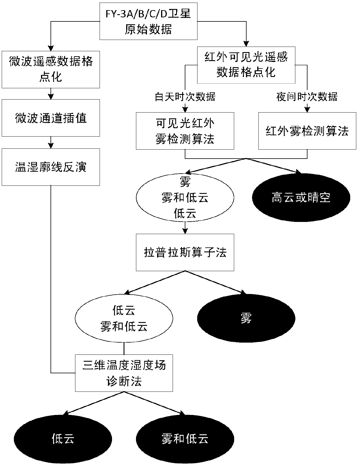
[0034] Such as figure 1 As shown, a sea fog monitoring method based on multi-source satellite remote sensing data includes the following steps:

[0035] 1) Preprocessing the satellite data.

[0036] The satellite data is FY-3 series satellites, NOAA series satellites or other polar or geostationary orbit satellites equipped with both visible light infrared and microwave remote sensing instruments, the visible light infrared remote sensing data and microwave remote sensing data carried.

[0037] Among them, microwave remote sensing data includes microwave remote sensing radiance temperature; visible light infrared remote sensing data includes visible light remote sensing data and infrared remote sensin...


PUM


Abstract

The invention discloses a sea fog monitoring method based on multi-source satellite remote sensing data. Visible light and infrared satellite remote sensing data are used to preliminarily identify a fog and low-cloud mixing area; satellite microwave remote sensing data are used to acquire a temperature and humidity vertical layered structure in the fog and low-cloud mixing area; as the fog and thelow cloud have different large humidity area heights, the heights of the large humidity areas are extracted through the humidity layered structure; and the fog and the low cloud can further be distinguished, and the fog monitoring correctness is effectively improved.

Description

Technical field [0001] The invention relates to a sea fog monitoring method based on multi-source satellite remote sensing data, belonging to the field of meteorological monitoring. Background technique [0002] Sea fog is a low-visibility weather phenomenon at sea (visibility is less than 1km). It has an important impact on marine national economic production activities such as port operations, ocean transportation, fishery production, and so on. Therefore, monitoring it is of great significance. Due to the lack of observational data at sea, it is impossible to directly obtain the monitoring information of sea fog distribution in a large area of ​​the sea through visibility observation. Satellite remote sensing technology has high time and space resolution, and its observation coverage is wide. It can quickly observe a large area of ​​the sea and extract sea fog information. It is one of the important means of sea fog monitoring. Satellite remote sensing has multiple detection ...

Claims


Application Information

Patent Timeline
Patent Type & Authority Applications(China)
IPC IPC(8): G01S17/95
CPCG01S17/95G01W1/06G01W2001/006G01S5/16G01S19/14G01W1/08
Inventor 陈昊谢真珍李超康志明
Owner JIANGSU METEOROLOGICAL OBSERVATORY
Why Eureka
Try Eureka