Optimization method and system of spatial graphic aggregation

An optimization method and graphics technology, applied in the field of geographic information system, can solve the problems of high cost and low efficiency, and achieve the effect of high matching degree, reducing production cost and improving production efficiency.

Inactive Publication Date: 2018-11-09
四川凯普顿信息技术股份有限公司
View PDF11 Cites 1 Cited by
  • Summary
  • Abstract
  • Description
  • Claims
  • Application Information

AI Technical Summary

Problems solved by technology

[0005] Aiming at the above-mentioned shortcomings existing in the prior art, the present invention provides an optimization method and...

Method used


Image

  • Optimization method and system of spatial graphic aggregation
  • Optimization method and system of spatial graphic aggregation

Examples


Embodiment Construction

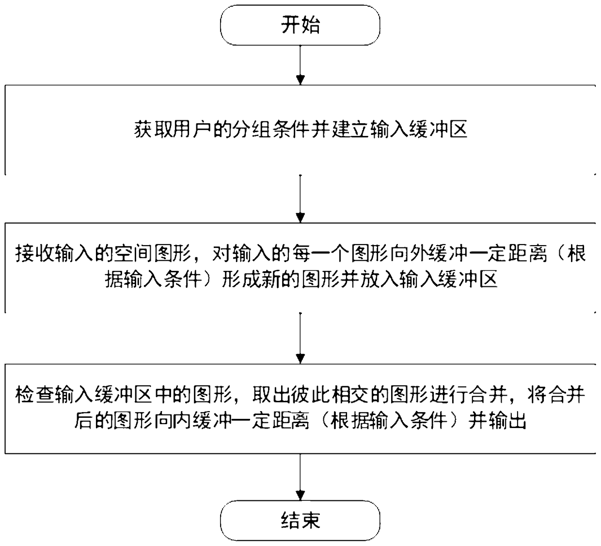
[0022] In order to make the purpose, technical solutions and advantages of the embodiments of the present invention more clear, the technical solutions in the embodiments of the present invention will be clearly and completely described below in conjunction with the drawings in the embodiments of the present invention. Apparently, the described embodiments are some, but not all, embodiments of the present invention. Based on the embodiments of the present invention, all other embodiments obtained by persons of ordinary skill in the art without creative efforts fall within the protection scope of the present invention.

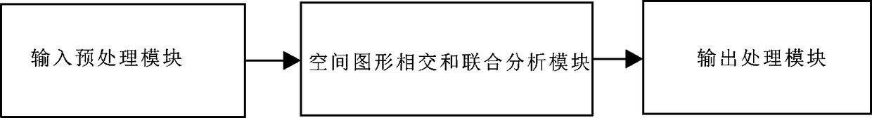
[0023] An optimization method and system for spatial graphic aggregation, such as figure 1 and figure 2 shown, including the following steps:

[0024] S1. Acquiring user grouping conditions and establishing an input buffer;

[0025] S2. Receive the input spatial graphics, buffer each input graphics for a certain distance (according to the input conditions) ...


PUM


Abstract

The invention relates to the field of the geographic information system, and specifically relates to an optimization method and system of spatial graphic aggregation. The method comprises the following steps: acquiring a grouping condition of users, and establishing an input cache, receiving input spatial graphs, outward caching each input graph with a certain distance (according to an input condition) to form a new graph and placing in the input cache, checking the graphs in the input cache, taking out the intersected graphs to combine, and inwardly caching the combined graph with a certain distance (according to the input condition) and then outputting. The system comprises an input preprocessing module for establishing the input cache and pre-inputting graphic data into the input cache,and a spatial graphic intersection and joint analysis module connected with the input preprocessing module and used for performing outward caching operation on the graphic data and performing inwardcaching operation on the mutually overlapped graphic data after the outward caching operation. Through the technical scheme provided by the invention, the defects of being low in efficiency and high in cost in the prior art can be effectively overcome.

Description

technical field [0001] The invention relates to the field of geographic information systems, in particular to an optimization method and system for gathering spatial graphics. Background technique [0002] Grouping a group of discrete spatial vector graphics according to the principle of spatial adjacency and consistent attributes into a single set of spatial data sets with a larger area has a wide range of applications in the field of geographic information systems (GIS). Take the agricultural industry as an example: The State Council issued the "Guiding Opinions on Establishing Grain Production Functional Zones and Important Agricultural Product Production Protection Zones" on April 10, 2017, striving to complete the delineation of 1.058 billion mu of "two districts" within three years The task is to basically complete the construction task of the "two districts" in 5 years. The "two districts" here refers to the division of a group of larger functional areas on the basis...

Claims


Application Information

Patent Timeline
IPC IPC(8): G06F17/30
Inventor 李昌松马进
Owner 四川凯普顿信息技术股份有限公司
Why Eureka
Try Eureka