
Induced arrow planning method, device, navigation system and storage medium

A technology of arrows and straight roads, applied in the information field, can solve problems such as insufficient fineness of two-dimensional vector graphics and map base maps, lack of lane road planning, and inability to provide users with lane navigation services, etc.

Active Publication Date: 2021-07-06
BAIDU ONLINE NETWORK TECH (BEIJIBG) CO LTD
View PDF6 Cites 0 Cited by
  • Summary
  • Abstract
  • Description
  • Claims
  • Application Information

AI Technical Summary

Problems solved by technology

The induced arrows in these two types of diagrams all rely on manual drawing processing, which is expensive
[0003] On the other hand, the existing two-dimensional vector diagrams and map base maps are not detailed enough, there is no road planning at the lane level, and the lane where the user is located is not marked in the map, so it is impossible to provide users with lane-level navigation services

Method used


Image

  • Induced arrow planning method, device, navigation system and storage medium
  • Induced arrow planning method, device, navigation system and storage medium
  • Induced arrow planning method, device, navigation system and storage medium

Examples


Embodiment approach

[0088] Figure 12 A structural block diagram of an induced arrow planning device provided by another embodiment of the present invention. Such as Figure 12 As shown, according to an embodiment of the induced arrow planning device of the present invention, the steering judging unit 200 includes: a filtering subunit 210 for removing straight roads without lane texture from the set of straight roads; a reference straight road judging subunit 220. It is used to obtain a reference straight road for each turning straight road to be calculated, the reference straight road is the next straight road connected to the turning straight road to be calculated after removing the road without lane texture, and the road without lane texture Including a virtual straight road or a straight road whose length is less than a predetermined threshold; the steering judging subunit 230 is configured to make steering judgment on the connection point between the straight road to be calculated and the ...


PUM


Abstract

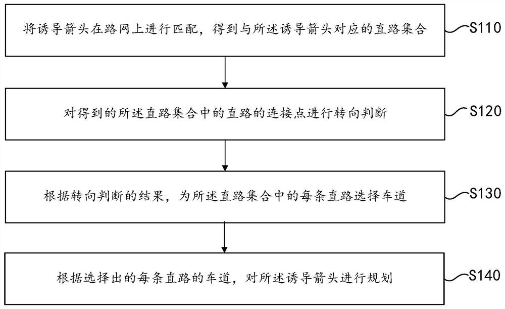
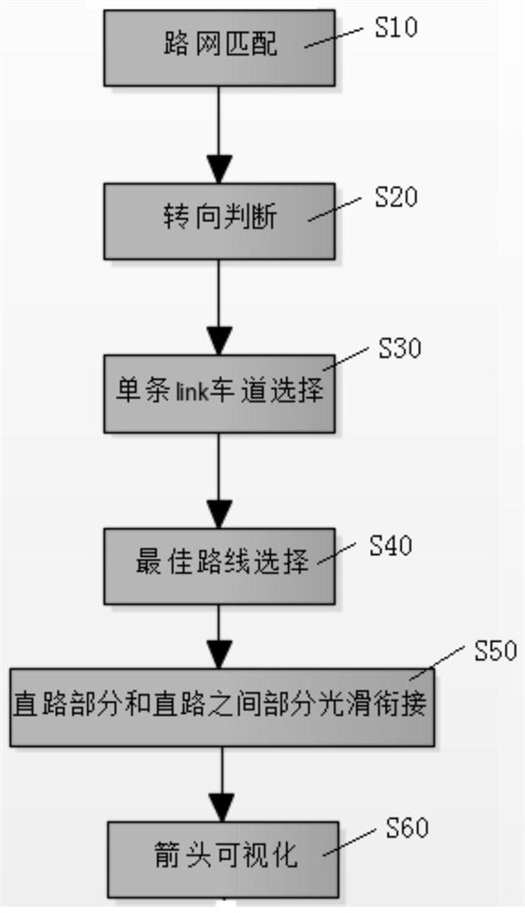
Embodiments of the present invention provide a guiding arrow planning method, device, navigation system and storage medium. The method includes: matching the inducing arrows on the road network to obtain a set of straight roads corresponding to the inducing arrows; performing a steering judgment on the connection points of the straight roads in the obtained straight road set; according to the result of the steering judgment, for the A lane is selected for each straight road in the straight road set; and the guiding arrow is planned according to the selected lane of each straight road. The embodiment of the present invention uses the shape points given by the road calculation and the vehicle information on the straight road in the road network to calculate the shortest induced arrow plan for driving in the correct lane, automatic production, and high navigation accuracy.

Description

technical field [0001] The invention relates to the field of information technology, in particular to a method, device, navigation system and storage medium for guiding arrow planning. Background technique [0002] Existing three-dimensional magnified diagrams include model diagrams and actual diagrams. Wherein, the mode picture includes turning signs, such as left-turn signs or right-turn signs; the real-view picture includes real-scene pictures rendered by 3ds max (3D Studio Max) such as intersections and street views. The induced arrows in these two types of graphs all rely on manual drawing processing, and the processing cost is high. [0003] On the other hand, the existing two-dimensional vector graphics and map base maps are not detailed enough, there is no lane-level road planning, and the user's lane is not marked in the map, so it cannot provide users with lane-level navigation services. Contents of the invention [0004] Embodiments of the present invention pr...

Claims


Application Information

Patent Timeline
Patent Type & Authority Patents(China)
IPC IPC(8): G01C21/36
CPCG01C21/3632
Inventor 孙晔邵胜均朱举章郭欣
Owner BAIDU ONLINE NETWORK TECH (BEIJIBG) CO LTD
Learn More